|
Posted: 5/6/2024 7:34:56 AM EDT
[Last Edit: Red-Stater]
If you’re in the highlighted areas (such as myself, in the bright pink bullseye), you NEED to be weather aware today into tonight. This is a very high end setup, with a strong likelihood of multiple long tracked, violent (EF3+) tornados. I pray that this event fizzles out, but it could be another historic day here in Tornado Alley. Hold on to your butts, friends!
Day 1 Convective Outlook NWS Storm Prediction Center Norman OK 1102 AM CDT Mon May 06 2024 Valid 061630Z - 071200Z ...THERE IS A HIGH RISK OF SEVERE THUNDERSTORMS FROM CENTRAL AND NORTHERN OKLAHOMA INTO SOUTH-CENTRAL KANSAS... ...SUMMARY... A regional outbreak of severe weather with multiple intense (EF3+), long-tracked tornadoes, as well as very large hail and severe thunderstorm gusts, is expected over parts of the south-central Plains from this afternoon through evening. ...NE/KS/OK to north TX... Water-vapor imagery late this morning shows a potent mid- to upper-level trough/low over the central Rockies with a speed max moving through the base of the trough and into the southern and central High Plains. This negatively tilted mid level trough will continue northeast to near the Black Hills by this evening while its southern portion overspreads the KS/OK corridor. The 12z Amarillo, TX raob showed the leading edge of stronger 700-600 mb southwesterly flow nosing eastward into the High Plains. A cyclone near the NE Panhandle this morning will deepen as it moves north-northeast to the SD/ND border early Tuesday morning. An associated Pacific front will push east into the High Plains and overtake the northern portion of the dryline across parts of the central High Plains this afternoon into this evening. Farther south, a dryline will mix east into western OK by late this afternoon with a broad moist/unstable warm sector across the southern Great Plains and becoming increasingly pinched in spatial width farther north into the north-central Great Plains. An attendant warm front will advance northward from OK into the lower MO Valley by early evening and later into the mid MS Valley. Visible satellite imagery shows considerable low stratus and stratocumulus from north TX into the central Great Plains. The 12z Fort Worth, TX raob sampled the richer low-level moisture (15 g/kg lowest 100mb mean mixing ratio) compared to areas farther north. Surface analysis late this morning shows rapid northward transport of moisture into OK with 65-70 deg F dewpoints advecting northward through OK to the KS border. This plume of richer moisture will continue northward today beneath an EML and lead to moderate destabilization over NE with a very to extremely unstable airmass forecast to develop farther south over the southern half of KS into OK and adjacent north TX. Initial thunderstorm development is likely as the upper forcing impinges on the northwestern periphery of the moist/unstable sector across the central High Plains (western KS/NE) and northward into SD with time. Steep 700-500 mb lapse rates and strengthening flow becoming more meridional with time will favor organized storms, including supercells and bands of storms with an associated isolated to scattered risk for hail/wind and perhaps a few tornadoes. Farther south, the erosion of the cap is expected initially over the KS portion of the dryline and perhaps into northwest OK by the mid afternoon. Strengthening flow through the column combined with strong to extreme buoyancy (2500-4500 J/kg MLCAPE) --from I-70 in central KS to I-40 in central OK-- will strongly favor supercell development. Strong upper-level diffluence across the central Great Plains and intensifying southwesterly to westerly 250-mb flow, which will result in very long hodographs, will strongly favor discrete storm modes, at least initially. Large to giant hail (3-4 inches in diameter) is possible with the more robust supercells. The LLJ is forecast to be strongest over KS northward into the north-central Plains through 21z. During the 21-00z timeframe, the flow associated with the LLJ will strengthen over OK acting to enlarge hodographs. Climatologically large combinations of deep-layer shear, buoyancy, and SRH will result in extreme values of composite indices (STP 6-12) during the 22z-06z timeframe across the Moderate to High Risks. Several discrete supercells are expected to traverse across a large portion of the Moderate and High-Risk equivalent tornado probabilities. Tornadoes, some of which can be intense (EF3+), are forecast late this afternoon and well into the evening. Some model guidance shows regenerative supercell development across central OK this evening. Have extended the High Risk slightly farther south to account for this possibility ...20Z Update... Recent surface analysis places a low over far southeast MT, with an occluded front arcing southeastward to the triple point near far southwest SD/far north-central NE Panhandle. A cold front extends southward from this triple point across far eastern CO and then back south-southwestward across eastern NM. A dry line also extends southeastward from this triple point into south-central NE before arcing back more southward/south-southwestward across western KS, the eastern TX/OK Panhandles, and into TX Trans-Pecos. Thunderstorms developed quickly along the dryline from south-central NE into north-central KS, as well as ahead of the occluded front in southwest SD. General expectation outlined in the previous discussion (appended below) remains, with thunderstorm coverage and intensity expected to increase as the shortwave trough continue to progress northeastward into the central High Plains. Eventual organization into more of an eastward-progressing convective line is anticipated, with the resulting line moving across southern NE and northern KS. Primary threat with this line will be severe wind gusts up to 80 mph. Some line-embedded QLCS tornadoes are also possible, particularly as the line enters southeast NE and northeast KS later this evening amid a strengthening low-level jet. STP values from 3 to 5 appear likely across southeast KS ahead of the line this evening. Farther south (from south-central/southeast KS into most of OK), the airmass continues to destabilize ahead of the dryline. Upper 60s dewpoints are now approaching the KS/OK border, with low 70s dewpoints now moving into central OK. Visible satellite imagery continues to show relatively limited vertical development across OK, with some stable undulations noted as well, both of which are indicative of a capped airmass. This is verified by the 18Z OUN sounding, which showed that notable capping remains in place. This capping is a few degrees higher than estimated by the 12Z guidance. Even so, deepening cumulus has been noted along the dryline across the eastern TX/OK Panhandle, and recent initiation has occurred in southwest KS, both of which suggest initiation of additional storms farther south is probable around 20 to 22Z. Overall scenario for a potentially volatile afternoon and evening remains for south-central KS into western and central OK. An isolated storm could also develop in far northwest TX. Supercells capable of all severe hazards are still expected, with the environment becoming more favorable with time and eastern extent. All guidance continues to indicate STP values around 10 are likely in the 00 to 06Z timeframe across western and central OK. Giant hail up to 4" in diameter, severe gusts up to 80 mph, and long-track, intense tornadoes are all possible. Particularly Dangerous Situation (PDS) Tornado Watch #189 was recently issued to cover this threat. |
|
|
|
KS, USA
|
[#1]
Well I’m in Wichita area so I guess this is the end
Oh well |
|
|
|
[#2]
Fuck tornadoes!
|
|
|
|
|
[#3]
Okies need a break.
16 inches of rain in less than a month. My area had grapefruit size hail in March, Then tornados that wiped out towns close to me. Now more chances today.  |
|
|
|
KS, USA
|
[#4]
Live in Hutchinson. So here we go!
|
|
|
|
[#5]
Pfft...I ain't worried bout no naders.
|
|
|
|
|
[Last Edit: Red-Stater]
[#6]
Originally Posted By 1shott: Okies need a break. 16 inches of rain in less than a month. My area had grapefruit size hail in March, Then tornados that wiped out towns close to me. Now more chances today. Same here (just on the Kansas side of the OK/KS state line, about an hour north of Tulsa). Probably had 5 or 6 tornados close by already. My little town got decimated by hail in March, too. Been a hell of a storm season so far, and today will be more of the same. I know we’re used to it in this part of the country, but sheesh… |
|
|
|
|
[#7]
3 of my HS friends are Meteorologists.
they are all giving heads up for major storms from 4PM-5AM. buckle up this evening Okies. |
|
|
|
|
[#8]
Be safe guys. Our day is Wed I believe
|
|
|
|
|
[#9]
Originally Posted By Amped: Be safe guys. Our day is Wed I believe Yep. Wednesday is looking serious, too. |
|
|
|
|
[#10]
Thanks OP.
|
|
|
|
|
[#11]
Wednesday looking pretty bad for a little further east.
It’s going to get HOT this week. |
|
|
|
|
[#12]
Thanks OP, I am in the red as well in SW OK.
They seem to start here and head NE so I will give you a heads up with how things are going. |
|
|
|
KS, USA
|
[#13]
Sitting on the edge of the orange ring here.
|
|
|
|
[#14]
I’m in the bullseye, yay
|
|
|
|
|
[Last Edit: Red-Stater]
[#15]
Originally Posted By USCG_CPO: Thanks OP, I am in the red as well in SW OK. They seem to start here and head NE so I will give you a heads up with how things are going. We get whatever Osage County, Oklahoma decides to chew up and spit out onto us. 
|
|
|
|
OK, USA
|
[#16]
Big hitters this evening.
|
|
|
|
[#17]
Will be watching closely.
|
|
|
|
|
[#18]
Stay safe guys. The night ones are the worst
|
|
|
|
|
[#19]
UPDATE IN OP: The Storm Prediction Center has issued a rare tornado-driven level 5/5 HIGH RISK for potions of central/northern Oklahoma into southern Kansas.
|
|
|
|
KS, USA
|
[#20]
This is like the third one of these in a row for Wichita. At this point, it comes off as a normal spring more than anything. The Weather agency that cries wolf and tall that.
|
|
|
|
[#21]
Originally Posted By Southernman077: Fuck tornadoes! |
|
|
|
|
[#22]
The night tornadoes are extremely frightening...EF3+. No thanks
|
|
|
|
|
[#23]
Driving home to KC after the cards game is StL. Could be quite the show on I-70
Been a hell of a storm season already. Stay safe fellas! |
|
|
|
|
[#24]
The outlook is looking nastier by the minute…
|
|
|
|
IL, USA
|
[Last Edit: big_sti]
[#25]
It just got raised to the highest level possible, 30% hatch for EF2 and above. Major tornado outbreak expected.
First high risk for the plains in 5 + years. |
|
|
|
[#26]
Originally Posted By big_sti: It just got raised to the highest level possible, 30% hatch for EF2 and above. Major tornado outbreak expected Looking imminent, at this point. |
|
|
|
USA
|
[#27]
Best of luck to y'all. I kinda miss spring in Oklahoma and kinda not.
Glad I don't live in Moore right about now.
|
|
|
|
[#28]
Originally Posted By broken_reticle: Best of luck to y'all. I kinda miss spring in Oklahoma and kinda not. Glad I don't live in Moore right about now. I have family strung across the whole risk area, including in Moore. Nervous |
|
|
|
|
[#29]
|
|
|
|
|
[#30]
Originally Posted By Red-Stater: https://www.ar15.com/media/mediaFiles/484415/IMG_1044_jpeg-3206843.JPG Oh thats cool  The 9 is right on top of me. The 9 is right on top of me.
|
|
|
|
|
[#31]
Originally Posted By USCG_CPO: Oh thats cool The 9 is right on top of me.Godspeed, friend! I’m sitting at a cool 7 here in southeast Kansas. |
|
|
|
SD, USA
|
[#32]
Our humidity is 89% way up here in SoDak where it's normally 20% on average. Dew point in the fifties.
It's not often we get gulf moisture this far north. Stay safe down there, it looks like it could be a rough afternoon/ evening for you guys. As a sidenote, we drove through Sulfur, OK on the way back from the eclipse and my wife thought that it was one of the prettiest towns we saw on our trip. So much so, she said that maybe we should retire there and was looking on Zillow at houses there. Then the storms hit later. I was impressed by the local leadership during their press conference. It was nice to see some competency displayed on TV and the obvious outpouring of local help to the town. Neighbors helping neighbors, as it should be. |
|
|
|
[#33]
Remember tornadoes are just as scared of you as you are of them.
Give em a hearty "go on, get outta here!" like you would a coyote or any other pest and they'll run right off. |
|
|
|
|
[#34]
Originally Posted By straatconst: Our humidity is 89% way up here in SoDak where it's normally 20% on average. Dew point in the fifties. It's not often we get gulf moisture this far north. Stay safe down there, it looks like it could be a rough afternoon/ evening for you guys. As a sidenote, we drove through Sulfur, OK on the way back from the eclipse and my wife thought that it was one of the prettiest towns we saw on our trip. So much so, she said that maybe we should retire there and was looking on Zillow at houses there. Then the storms hit later. I was impressed by the local leadership during their press conference. It was nice to see some competency displayed on TV and the obvious outpouring of local help to the town. Neighbors helping neighbors, as it should be. Us Okies have been thru this shit before, we pretty much have it down in response to these events. I am about 30 miles north of Sulphur. It was one hairy ride thats for sure. My neighbors jumped in my cellar then sent me a text they were there LOL. They get a pass, they had some whiskey with them. |
|
|
|
|
[#35]
Originally Posted By Notcalifornialegal: Remember tornadoes are just as scared of you as you are of them. Give em a hearty "go on, get outta here!" like you would a coyote or any other pest and they'll run right off. Applies just as well to Oklahoma. |
|
|
|
TX, USA
|
[#36]
Originally Posted By USCG_CPO: Oh thats cool The 9 is right on top of me.Originally Posted By USCG_CPO: Originally Posted By Red-Stater: https://www.ar15.com/media/mediaFiles/484415/IMG_1044_jpeg-3206843.JPG Oh thats cool The 9 is right on top of me.Pack a bag and go spend the day and night in the panhandle. |
|
|
|
[#37]
https://x.com/reedtimmerusa/status/1787489812728967424?s=46
Update on today’s expected tornado outbreak from Reed Timmer. |
|
|
|
|
[#38]
Originally Posted By Red-Stater: https://www.ar15.com/media/mediaFiles/484415/IMG_1044_jpeg-3206843.JPG |
|
|
|
|
[#39]
SigTor is 10.0+ for the OKC area
|
|
|
|
|
[#40]
Stay woke midwest bros!
|
|
|
|
|
[Last Edit: mancow]
[#41]
Originally Posted By USCG_CPO: Oh thats cool The 9 is right on top of me.Originally Posted By USCG_CPO: Originally Posted By Red-Stater: https://www.ar15.com/media/mediaFiles/484415/IMG_1044_jpeg-3206843.JPG Oh thats cool The 9 is right on top of me.Hey at least you can say you had a 9 on you. |
|
|
|
|
[#42]
Originally Posted By PTR32Sooner: SigTor is 10.0+ for the OKC area Lots of family there. I’ll be keeping a close eye on the OKC area tonight. |
|
|
|
|
[#43]
Originally Posted By Red-Stater: Lots of family there. I’ll be keeping a close eye on the OKC area tonight. Originally Posted By Red-Stater: Originally Posted By PTR32Sooner: SigTor is 10.0+ for the OKC area Lots of family there. I’ll be keeping a close eye on the OKC area tonight. That's where I live |
|
|
|
|
[Last Edit: Red-Stater]
[#44]
Originally Posted By PTR32Sooner: That's where I live Originally Posted By PTR32Sooner: Originally Posted By Red-Stater: Originally Posted By PTR32Sooner: SigTor is 10.0+ for the OKC area Lots of family there. I’ll be keeping a close eye on the OKC area tonight. That's where I live May the Lord be with you, my Okie friend! |
|
|
|
|
[#45]
Originally Posted By Red-Stater: May the Lord be with you, my Okie friend! With all of us |
|
|
|
|
[#46]
Originally Posted By PTR32Sooner: With all of us Originally Posted By PTR32Sooner: Originally Posted By Red-Stater: May the Lord be with you, my Okie friend! With all of us Yessir, Amen. Reed Timmer is saying this is shaping up to be the worst tornado outbreak since May of 2011. Turns my gut in a knot just thinking about it. |
|
|
|
|
[Last Edit: PTR32Sooner]
[#47]
Originally Posted By Red-Stater: Yessir, Amen. Reed Timmer is saying this is shaping up to be the worst tornado outbreak since May of 2011. Turns my gut in a knot just thinking about it. Friend of mine is a meteorologist at KFOR here in OKC and said the last time he saw the atmosphere this primed over the OKC metro area was 5/20/2013 |
|
|
|
|
[Last Edit: Red-Stater]
[#48]
Convective Chronicles: Forecast discussion of today’s event.
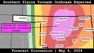 Forecast Discussion - May 6, 2024 - Southern Plains Tornado Outbreak Expected |
|
|
|
|
[#49]
I was in Oklahoma City last week. I paid $10 for the Radar Omega app thinking it was 10 bucks a month and I would cancel. Nope, it's a one time $10.00 and I found it is 100% worth it. I don't usually pay for apps, but I would pay 5x for this one.
|
|
|
|
AR, USA
|
[#50]
Originally Posted By PTR32Sooner: SigTor is 10.0+ for the OKC area 10+??? I had assumed the scale was 0-10, with 10 being almost an outlier, kinda like the richter scale. I've seen 8s and couple 9s but damn. |
|
|
 Win a FREE Membership!
Sign up for the ARFCOM weekly newsletter and be entered to win a free ARFCOM membership. One new winner* is announced every week!
You will receive an email every Friday morning featuring the latest chatter from the hottest topics, breaking news surrounding legislation, as well as exclusive deals only available to ARFCOM email subscribers.

AR15.COM is the world's largest firearm community and is a gathering place for firearm enthusiasts of all types.
From hunters and military members, to competition shooters and general firearm enthusiasts, we welcome anyone who values and respects the way of the firearm.

Subscribe to our monthly Newsletter to receive firearm news, product discounts from your favorite Industry Partners, and more.
Copyright © 1996-2024 AR15.COM LLC. All Rights Reserved.
Any use of this content without express written consent is prohibited.
AR15.Com reserves the right to overwrite or replace any affiliate, commercial, or monetizable links, posted by users, with our own.


