|
[#1]
150?
EDIT: BOOM - HEADSHOT. 
|
|
|
|
[#2]
Quoted:
That's just the surface, the weir extends down below that. The weir probably has as much height below grade as above it. I am skeptical of that but am not going back to find the cross section...assuming that it is even close to accurate. That rocky area is not what I would consider viable bedrock for use as an emergency spillway. |
|
|
|
[#3]
Quoted:
Did you see the cross section drawing that was posted about 20 times? What you see is all there is. The sill for the water to land on is even with the bottom of the weir. I'm pretty sure that drawing was just that, a drawing. I'm sure the prints show what was actually done |
|
|
|
[#4]
Quoted:
Of course that isn't a trivial amount of excavation and construction work to do, but perhaps they don't have to dig all new footings, just dig to tie it into the hill better, and then somehow anchor the new poured concrete to the old weir. Way out of my lane though... Just go to Home Depot and get a box of hurricane ties and really good adhesive. |
|
|
|
[#5]
Quoted:
Here is why people react poorly. "Dam" is not the emergency spillway. The parking lot may have about half of the emergency spillway alongside it but it (the emergency spillway) is not the "dam." Quoted:
Quoted:
If there are sinkholes in the parking lot, the dam is already undermined. Here is why people react poorly. "Dam" is not the emergency spillway. The parking lot may have about half of the emergency spillway alongside it but it (the emergency spillway) is not the "dam." The emergency spillway is absolutely and inseperably part of the dam. They built it on top of shit thappened to be sitting there but the plan of building that big ass racist against water wall included calling up the reserves to deport illegal water if needed. |
|
|
|
[#6]
Quoted:
They are pissing into the ocean, acting as if it matters. Sort of the definition of "Optics". |
|
|
|
[#7]
Quoted:
At this point of Monday Morning Quarterbacking it is pretty clear they should have never tested the E Spillway. They almost had a catastrophic failure and had to evac 200000. Upping the release of the main spillway and monitoring the erosion of the flume, in hindsight was much safe in the short term. The problem is can the damaged flume of the main spillway survive every drop of H2O in that water shed? Time will tell.  Quoted:
The spillway being damaged was a bad thing but why on earth did they decide to use the emergency spillway?
Isn't an emergency spillway an absolute last resort, Hail Mary to save the main dam incase shit goes sideways on the main spillway. As in the main spillway won't flow any water for whatever reason. Why didn't they ramp up the output on the spillway and monitor the erosion early on before deciding on the E spillway option? After all said and done, they did ramp up to 100K cfs and the spillway wasn't damaged too much more. Didn't the E spillway only put out 12K cfs. If so, their cost-benefit analysis ration was way off. At this point of Monday Morning Quarterbacking it is pretty clear they should have never tested the E Spillway. They almost had a catastrophic failure and had to evac 200000. Upping the release of the main spillway and monitoring the erosion of the flume, in hindsight was much safe in the short term. The problem is can the damaged flume of the main spillway survive every drop of H2O in that water shed? Time will tell. |
|
|
|
[#8]
Quoted:
north valley community foundation Nvcf I know board members, the money is being distributed straight to the local points of need. I'd prefer to not handle peoples funds. Elks lodge has a bar! Direct link for donations: http://nvcf.org/fund/oroville-evacuation-fund/ |
|
|
|
[#9]
Quoted:
I'm not very capable but I am willing to Bill insane hours fro insane pay, sign me up Quoted:
Quoted:
Quoted:
Holy shit! I have a relative there hauling rock to the dam. I did not know where he was living until he started putting pictures up on his facebook. One pic he is posting from his truck with a caption "Heading to Marysville for a load of rock then to the dam in orriville and hope it don't disappear". I am insanely capable of working insane hours for insane pay. Wait, wut ? I already do that.... |
|
|
|
[#10]
Quoted:
The spillway being damaged was a bad thing but why on earth did they decide to use the emergency spillway?
Isn't an emergency spillway an absolute last resort, Hail Mary to save the main dam incase shit goes sideways on the main spillway. As in the main spillway won't flow any water for whatever reason. Why didn't they ramp up the output on the spillway and monitor the erosion early on before deciding on the E spillway option? After all said and done, they did ramp up to 100K cfs and the spillway wasn't damaged too much more. Didn't the E spillway only put out 12K cfs. If so, their cost-benefit analysis ration was way off. I'm pretty sure this has been explained at least once on every page of this thread... |
|
|
|
[#11]
Quoted:
License still not issued it has been in the renewal process for over a decade. --ETA: Lawsuits from Sierra Club and others wanting emergency spillway to be modified the way they are doing it today, and others have tied it up. More Info from CA DWR itself on the license problems. Quoted:
Quoted:
You have repeatedly stated that the dam was no longer licensed by the FERC, as of 2005, but there's a settlement agreement for relicensing the dam in 2006, and nothing in that agreement covers anything about increasing capacity, the bulk of it talks about remediation measures for various forms of wildlife (snakes, fish, bald eagles, etc...). License still not issued it has been in the renewal process for over a decade. --ETA: Lawsuits from Sierra Club and others wanting emergency spillway to be modified the way they are doing it today, and others have tied it up. More Info from CA DWR itself on the license problems. Yet when I look, the dam is operating under a year-to-year license issued by the FERC and the only issue preventing issuance of the final license has to do with an aquatic biological opinion from the National Marine Fisheries Service, the FERC staff had recommended that a new license be approved once all of the wildlife management concerns had been addressed. NOTHING about modifications to the structural integrity of the dam or requiring different inspections (provided they were complying with the applicable Army Corps of Engineers standards, however, no statement is made regarding evidence of noncompliance or penalties if such is detected). |
|
|
|
[#12]
Quoted:
nope, it has to be lower than the weir - or you have a dam. They wanted 1700 feet of weir at 901' elevation. The parking lot is a non-issue and is sacrificial to a flood event. No one is going to be parking there during a flood anyway Tell me how water is flowing from some distance BELOW the top of the weir along the parking lot section? That was clearly visible in about three spots when people were looking at the "hole." |
|
|
|
[#13]
Quoted:
I'm pretty sure this has been explained at least once on every page of this thread... I'm pretty sure that everything that hasn't been explained at least once on every page of this thread has been ignored by several posters. And several things that have. |
|
|
|
[#14]
Quoted:
I am skeptical of that but am not going back to find the cross section...assuming that it is even close to accurate. That rocky area is not what I would consider viable bedrock for use as an emergency spillway. According to the drawing posted here a few time the weir ends at the splash apron. |
|
|
|
[#15]
Probably already posted....but I am not going through the last 30 pages!
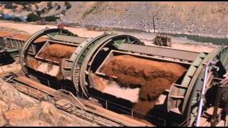 "The Birth of Oroville Dam" - produced and directed by Mark S Lambert |
|
|
|
[#16]
Needs a bunch of these full of Bentonite, lakeside of e-spill.

ETA: lucky draw on that tail number. |
|
|
|
[#17]
30 pages in a couple of hours? What did I miss?
ETA: math, that's what I missed. That tab on page 120 was from last night... |
|
|
|
[#18]
Quoted:
If it extended down below grade equally as far as what we can see, I'm sure that would have been shown in the cross section. https://www.AR15.Com/media/mediaFiles/268039/Screenshot-2017-02-12-12-10-57-1-145248.png Quoted:
Quoted:
That's not a blueprint. It's just an illustration to show the shape of the weir. If it extended down below grade equally as far as what we can see, I'm sure that would have been shown in the cross section. https://www.AR15.Com/media/mediaFiles/268039/Screenshot-2017-02-12-12-10-57-1-145248.png You're sure based on what? Since the base construction would differ depending on where each section of it sits it's common to leave it out of a detail of the above grade structure |
|
|
|
[#19]
Quoted:
Some great photos of the dam construction. http://www.nbclosangeles.com/multimedia/Oroville-Dam-Flooding-History-California-Water-Reservoir-Photos-413590093.html http://media.nbclosangeles.com/images/987*604/VA_1663-1_Oroville_04_29_1963.jpg Contractors use a high pressure water hose to clean the core block area at the Oroville damsite, which was required before the 231,000 cubic yards of concrete could be poured to form the core block. Photo taken April 29, 1963. I love how a black guy is doing the work while 3 white guys document it. |
|
|
|
[#20]
|
|
|
|
[#21]
Quoted:
I am insanely capable of working insane hours for insane pay. Wait, wut ? I already do that.... Quoted:
Quoted:
Quoted:
Quoted:
Holy shit! I have a relative there hauling rock to the dam. I did not know where he was living until he started putting pictures up on his facebook. One pic he is posting from his truck with a caption "Heading to Marysville for a load of rock then to the dam in orriville and hope it don't disappear". I am insanely capable of working insane hours for insane pay. Wait, wut ? I already do that.... I am super insanely capable of working super insanely low hours for super insanely pay. 
|
|
|
|
[#22]
Quoted:
nope is the answer you seek "Nope" is most definitely not the answer I seek. Unfortunately I fear it is the answer I will get. Good Luck main spillway flume. You have long and difficult runoff season ahead of you and it literately has not even started.
|
|
|
|
[#23]
Quoted:
I've been following this since the beginning but seeing photos that show scale is still pretty awe inspiring. Though saying that, please understand that I know there are tens of thousands of people that are suffering because of this fuck up. This is also an important lesson for engineers that are responsible for the safety of the public. Don't sign off on something you aren't sure of, bonuses or management pressure be damned. It'll all work out until it doesn't, then it's your ass that's going to have your license pulled, terminated, and possibly prosecuted. Or worse than that, you kill people. |
|
|
|
[#24]
Quoted:
Needs a bunch of these full of Bentonite, lakeside of e-spill. http://todgermanica.files.wordpress.com/2015/07/10tanker-3abqjournal.jpg ETA: lucky draw on that tail number. It's amazing how low they are allowed to fly those things. You'd think they would suffer a lot more bird strikes using them that way... |
|
|
|
[#25]
Quoted:
The problem is can the damaged flume of the main spillway survive every drop of H2O in that water shed? No. The bottom of the main spillway is reportedly around 811 feet MSL. It can't drain the entire reservoir if Moses walked across the top of the water. |
|
|
|
[#26]
Been out most the day today. Nothing big seems to have happened today which is good. But i have a question that I've been pondering for while. The rain over the watershed is supposed to start on Wednesday night correct? What are the possible side effects of heavy rainfall on the regular spillway and E-spillway? I'm talking about mudslides and further erosion without any lake water going through the spillway.We see what happens on a hillside that's been involved in a fire. Heavy rain + Exposed ground and roots = Mudslide. I don't see it been any different here.
|
|
|
|
[#27]
Quoted:
It's amazing how low they are allowed to fly those things. You'd think they would suffer a lot more bird strikes using them that way... Quoted:
Quoted:
Needs a bunch of these full of Bentonite, lakeside of e-spill. http://todgermanica.files.wordpress.com/2015/07/10tanker-3abqjournal.jpg ETA: lucky draw on that tail number. It's amazing how low they are allowed to fly those things. You'd think they would suffer a lot more bird strikes using them that way... They don't have a choice but to fly low. Otherwise the retardant is ineffective. Not to mention, birds do fly at higher altitudes as well. |
|
|
|
[#28]
Quoted:
Right toward the power lines so ugh, lose lose Quoted:
Quoted:
The black is what it's doing and the red is what it could do. The red would be better because that's going away from the complex. Right toward the power lines so ugh, lose lose Better the high tension towers than the e-spillway I would think. But what do I know? I'm just a guy who drives a tugboat.
|
|
|
|
[#29]
Quoted:
Some construction photos of the dam in the 60's https://www.AR15.Com/media/mediaFiles/148098/IMG-0204-146380.png https://www.AR15.Com/media/mediaFiles/148098/IMG-0203-146381.png https://www.AR15.Com/media/mediaFiles/148098/IMG-0202-146382.png That's pretty cool. |
|
|
|
[#30]
In the 26 hours since the OMG RUN Order, they've managed to lower the reservoir by an astounding 8.5 feet.
I don't see that matching the "Down 50 feet" by Thursday they gave at one of the Baghdad Bob Conferences. |
|
|
|
[#31]
Quoted:
Better the high tension towers than the e-spillway I would think. But what do I know? I'm just a guy who drives a tugboat. Quoted:
Quoted:
Quoted:
The black is what it's doing and the red is what it could do. The red would be better because that's going away from the complex. Right toward the power lines so ugh, lose lose Better the high tension towers than the e-spillway I would think. But what do I know? I'm just a guy who drives a tugboat. I always thought driving a tugboat would be fun. Have you done a 'ask a guy who's driving a tugboat anything' thread? |
|
|
|
[#32]
|
|
|
|
[#33]
Quoted:
No. The bottom of the main spillway is reportedly around 811 feet MSL. It can't drain the entire reservoir if Moses walked across the top of the water. No water currently in that water shed (above the res) . 
That was my point. All the rain and snow above the res 901 ft line is going to have to go down that damaged flume. Can it hold? I hope so but it seems a long shot. |
|
|
|
[#34]
Quoted:
I always thought driving a tugboat would be fun. Have you done a 'ask a guy who's driving a tugboat anything' thread? I've done a few but none of my threads ever go more than 2-3 pages. |
|
|
|
[#36]
They should rename the town "Spillway Falls"
|
|
|
|
[#37]
Quoted:
In the 26 hours since the OMG RUN Order, they've managed to lower the reservoir by an astounding 8.5 feet. I don't see that matching the "Down 50 feet" by Thursday they gave at one of the Baghdad Bob Conferences. They are back to hedging the primary spillway flow. For what godly reason, I have no idea. Keep it full water hoarding or spillway undermining the dam is all I have got. Maybe some downstream don't flood the moonbat sanctuary shit? |
|
|
|
[#38]
Ok, it finally occurred to me to attempt to look at historical data instead of hysterical...
Looking at the electronic records is enlightening. Going back to the earliest online data (around 1986), it shows there have been only 4 instances where the peak inflow has been above 100k cfs. I understand that this can change, but based on past info, I would be comfortable right now knowing that only one time has it ever flowed so much that the current partially disabled spillway was unable to keep up with the inflow. Click here to view all online inflow data charted |
|
|
|
[#39]
Anybody downstream that got a cheap house in a flood plain should start moving now, even if it means getting a loan. Avoid the rush! 
|
|
|
|
[#40]
Quoted:
I have my own pans, portable sluice, and plenty of vacation time. can i come with you? Quoted:
|
|
|
|
[#41]
 Failed To Load Title |
|
|
|
[#42]
All right, I just got home. Where are we at?
Clearly O town is fucked. The latest pictures show the cracks right beneath the Espill are the deathblow. Anyone with half a brain knows that it's not Fill it's decomposed granite or who knows what that's just rock sitting on top of a rock. ( The word from the people working on it who are not allowed to talk publicly is there are seven monster cracks beneath the emergency spillway ) I got to say the area i'm in is amazing. People are stepping over each other to help out. I was at the Elks Lodge today and they would shout out on Facebook or wherever that they needed x and within an hour three or four car fulls of X would show up. People were literally dropping off fresh Costco loads of stuff. |
|
|
|
[#43]
Quoted:
The problem with engineers is they lack seat of the pants experience. They apply numbers to a general situation and add a safety factor and stamp it and collect their paycheck. Which is fine and dandy unless you are a finish guy and there is no project funding left because it was all blown by the architects, engineers, soils and environmental studies before a shovel of dirt was moved. I'll call your bluff. Overly generalized statement is overly general. |
|
|
|
[#44]
Quoted:
No. The bottom of the main spillway is reportedly around 811 feet MSL. It can't drain the entire reservoir if Moses walked across the top of the water. The 811 is the base of the spillway gate structure. The base of the intakes looks like it's around 850ft according to the topo map (thin lines are spaced at 40ft on the right/dam side, 20ft on the left, town side): 
|
|
|
|
[#45]
Quoted:
The 811 is the base of the spillway gate structure. The base of the intakes looks like it's around 850ft according to the topo map (thin lines are spaced at 50ft): https://www.AR15.Com/media/mediaFiles/41058/oroville-topo-143550.png Those look like 40 ft contour intervals not 50 |
|
|
|
[#46]
Quoted:
Ok, it finally occurred to me to attempt to look at historical data instead of hysterical... Looking at the electronic records is enlightening. Going back to the earliest online data (around 1986), it shows there have been only 4 instances where the peak inflow has been above 100k cfs. I understand that this can change, but based on past info, I would be comfortable right now knowing that only one time has it ever flowed so much that the current partially disabled spillway was unable to keep up with the inflow. Click here to view all online inflow data charted Have you looked at the weather forecast? |
|
|
|
[#47]
Quoted:
Probably already posted....but I am not going through the last 30 pages! Pretty amazing construction project. |
|
|
|
[#48]
Quoted:
All right, I just got home. Where are we at? Clearly O town is fucked. The latest pictures show the cracks right beneath the Espill are the deathblow. Anyone with half a brain knows that it's not Fill it's decomposed granite or who knows what that's just rock sitting on top of a rock. ( The word from the people working on it who are not allowed to talk publicly is there are seven monster cracks beneath the emergency spillway ) I got to say the area i'm in is amazing. People are stepping over each other to help out. I was at the Elks Lodge today and they would shout out on Facebook or wherever that they needed x and within an hour three or four car fulls of X would show up. People were literally dropping off fresh Costco loads of stuff. That is fantastic to hear, and perhaps through all of this the decency of humanity shows through. Maybe even a few former political enemies can find common ground over this. That was awesome of you to donate your photo earnings to help others...speaks pretty highly of your character! |
|
|
|
[#49]
Quoted:
The 811 is the base of the spillway gate structure. The base of the intakes looks like it's around 850ft according to the topo map (thin lines are spaced at 40ft on the right/dam side, 20ft on the left, town side): https://www.AR15.Com/media/mediaFiles/41058/oroville-topo-143550.png ... |
|
|
|
[#50]
Quoted:
Have you looked at the weather forecast? Quoted:
Quoted:
Ok, it finally occurred to me to attempt to look at historical data instead of hysterical... Looking at the electronic records is enlightening. Going back to the earliest online data (around 1986), it shows there have been only 4 instances where the peak inflow has been above 100k cfs. I understand that this can change, but based on past info, I would be comfortable right now knowing that only one time has it ever flowed so much that the current partially disabled spillway was unable to keep up with the inflow. Click here to view all online inflow data charted Have you looked at the weather forecast? Here's a screencap from the livestream, doesn't look good for the rest of the week 
|
|
|
 Win a FREE Membership!
Sign up for the ARFCOM weekly newsletter and be entered to win a free ARFCOM membership. One new winner* is announced every week!
You will receive an email every Friday morning featuring the latest chatter from the hottest topics, breaking news surrounding legislation, as well as exclusive deals only available to ARFCOM email subscribers.

AR15.COM is the world's largest firearm community and is a gathering place for firearm enthusiasts of all types.
From hunters and military members, to competition shooters and general firearm enthusiasts, we welcome anyone who values and respects the way of the firearm.

Subscribe to our monthly Newsletter to receive firearm news, product discounts from your favorite Industry Partners, and more.
Copyright © 1996-2024 AR15.COM LLC. All Rights Reserved.
Any use of this content without express written consent is prohibited.
AR15.Com reserves the right to overwrite or replace any affiliate, commercial, or monetizable links, posted by users, with our own.