|
[#1]
Dali size container ship emergency generator power and steering
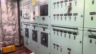 Dali size containership emergency generator power and steering |
|
|
|
[#2]
Quoted: God damn. A Chinamax drafts 79 feet. Down by the keel is practically like a submarine at that point. I wonder how thick the hull is down there to resist the pressure. .433 PSI per vertical foot of immersion for the hull pressure. Hull Plating to the bilge radius is probably 30 to 38 mm thick, and an AH material grade. |
|
|
|
[#3]
Quoted: .433 PSI per vertical foot of immersion for the hull pressure. Hull Plating to the bilge radius is probably 30 to 38 mm thick, and an AH material grade. How thick is a hull at the waterline, typically? |
|
|
|
[#4]
Quoted: Pay attention? Metal starts to move, get the fuck out. Quoted: Quoted: When dudes are flame cutting the steel members, how do they know that a massive amount of stored energy won’t be released when they complete the cut and unalive their asses? Or do they use expendable/disposable type guys for this type of work? Pay attention? Metal starts to move, get the fuck out. I've done torching. Truck frames, not bridges, but the principles are the same. Torch person works in tandem with the crane operator to cut, lift, and separate the pieces. Building demolition is somewhat the same. |
|
|
|
[#5]
Quoted: Dali size container ship steering system. How it's designed to not hit Francis Scott key bridge None of those redundant systems matter when you have a group of uneducated peasants operating the ship. |
|
|
|
[#6]
Quoted: The Baltimore harbor is dredged to 50' deep, the Key Bridge's former span and both spans of the Chesapeake Bay bridge are 158' to the water line. It is a very undersized port for today's ships. https://www.ar15.com/media/mediaFiles/195/Ship_measurements_comparison_svg_png-3174990.JPG Kharn Quoted: Quoted: Quoted: Quoted: So how tall does ARf think the replacement should be? The Bay Bridge and the original Key Bridge are/were both 158', severely limiting the ships that can reach the harbor. The two Bay Bridge spans were built in '52 and '73. Kharn It wouldn't hurt to make the Key bridge taller if the cost is going to be negligible - relatively speaking. I'm not sure it makes a lot of sense since the bay bridges limit the height of what gets to the Key bridge but it wouldn't hurt for possible future port expansion capabilities. The ship's draft might be the factor unless Maryland wants to dig the channel deeper. Maybe not, ships for the Suez Canal can go to 17 meters, 55 feet. Most of the rest are similar to Dali. The Baltimore harbor is dredged to 50' deep, the Key Bridge's former span and both spans of the Chesapeake Bay bridge are 158' to the water line. It is a very undersized port for today's ships. https://www.ar15.com/media/mediaFiles/195/Ship_measurements_comparison_svg_png-3174990.JPG Kharn I used this plot titled, "Average Draft by Containership Capacity" from https://transportgeography.org/contents/chapter5/maritime-transportation/draft-containership-capacity/  I didn't check the date of the report, and this plot is more or less a rule of thumb. Not that good without the axes defined and labeled; the top line is 18 meters. The port is preparing a bypass to the northeast side with a controlling depth of 11 feet for critical loads. Now I need the definition of controlling depth (I might be the only person here that looked at the charts for the harbor, I posted the depth of the navigation channel and the Dali draft days ago.) |
|
|
|
[#7]
Coming in hot..
 Ship collides with container crane causing it to collapse on southern Taiwan port |
|
|
|
[#8]
Rainy & fog on the live streams nothing happening today so far.
|
|
|
|
[#9]
Quoted: Rainy & fog on the live streams nothing happening today so far. |
|
|
|
[#10]
Quoted: Sal was saying on his YT that they're on a pause because of concerns with the gas line that is running under the impact area. I thought they turned the gas off. Without telling anybody. lol |
|
|
|
[#11]
A channel has opened for vessels clearing wreckage at the Baltimore bridge collapse site
 A channel has opened for vessels clearing wreckage at the Baltimore bridge collapse site The U.S. Coast Guard has opened a temporary, alternate channel for vessels involved in the clearing of debris at the site of the collapsed Francis Scott Key Bridge in Baltimore, part of a phased approach to opening the main channel leading to the vital port, officials said. |
|
|
|
[#12]
Quoted: A channel has opened for vessels clearing wreckage at the Baltimore bridge collapse site The U.S. Coast Guard has opened a temporary, alternate channel for vessels involved in the clearing of debris at the site of the collapsed Francis Scott Key Bridge in Baltimore, part of a phased approach to opening the main channel leading to the vital port, officials said. I wonder how the Chinese submarines are getting in and out of the harbor. |
|
|
|
[#13]
Quoted: I used this plot titled, "Average Draft by Containership Capacity" from https://transportgeography.org/contents/chapter5/maritime-transportation/draft-containership-capacity/ https://www.ar15.com/media/mediaFiles/348/1000000745-3175493.png I didn't check the date of the report, and this plot is more or less a rule of thumb. Not that good without the axes defined and labeled; the top line is 18 meters. The port is preparing a bypass to the northeast side with a controlling depth of 11 feet for critical loads. Now I need the definition of controlling depth (I might be the only person here that looked at the charts for the harbor, I posted the depth of the navigation channel and the Dali draft days ago.) Quoted: Quoted: Quoted: Quoted: Quoted: So how tall does ARf think the replacement should be? The Bay Bridge and the original Key Bridge are/were both 158', severely limiting the ships that can reach the harbor. The two Bay Bridge spans were built in '52 and '73. Kharn It wouldn't hurt to make the Key bridge taller if the cost is going to be negligible - relatively speaking. I'm not sure it makes a lot of sense since the bay bridges limit the height of what gets to the Key bridge but it wouldn't hurt for possible future port expansion capabilities. The ship's draft might be the factor unless Maryland wants to dig the channel deeper. Maybe not, ships for the Suez Canal can go to 17 meters, 55 feet. Most of the rest are similar to Dali. The Baltimore harbor is dredged to 50' deep, the Key Bridge's former span and both spans of the Chesapeake Bay bridge are 158' to the water line. It is a very undersized port for today's ships. https://www.ar15.com/media/mediaFiles/195/Ship_measurements_comparison_svg_png-3174990.JPG Kharn I used this plot titled, "Average Draft by Containership Capacity" from https://transportgeography.org/contents/chapter5/maritime-transportation/draft-containership-capacity/ https://www.ar15.com/media/mediaFiles/348/1000000745-3175493.png I didn't check the date of the report, and this plot is more or less a rule of thumb. Not that good without the axes defined and labeled; the top line is 18 meters. The port is preparing a bypass to the northeast side with a controlling depth of 11 feet for critical loads. Now I need the definition of controlling depth (I might be the only person here that looked at the charts for the harbor, I posted the depth of the navigation channel and the Dali draft days ago.) Not helpful without the scale. Depth is inverted (from a typical graph with increasing on X and Y) with the deepest at the bottom and shallowest at the top so it's confusing. 
|
|
|
|
[#14]
MV Dali & Baltimore Bridge April 1, 2024 Update | New Channel, Who is in Charge & End of NTSB News
 MV Dali & Baltimore Bridge April 1, 2024 Update | New Channel, Who is in Charge & End of NTSB News |
|
|
|
[#15]
Quoted: Not helpful without the scale. Depth is inverted (from a typical graph with increasing on X and Y) with the deepest at the bottom and shallowest at the top so it's confusing. https://i.imgur.com/yTNWeDu.png Quoted: Quoted: Quoted: Quoted: Quoted: Quoted: So how tall does ARf think the replacement should be? The Bay Bridge and the original Key Bridge are/were both 158', severely limiting the ships that can reach the harbor. The two Bay Bridge spans were built in '52 and '73. Kharn It wouldn't hurt to make the Key bridge taller if the cost is going to be negligible - relatively speaking. I'm not sure it makes a lot of sense since the bay bridges limit the height of what gets to the Key bridge but it wouldn't hurt for possible future port expansion capabilities. The ship's draft might be the factor unless Maryland wants to dig the channel deeper. Maybe not, ships for the Suez Canal can go to 17 meters, 55 feet. Most of the rest are similar to Dali. The Baltimore harbor is dredged to 50' deep, the Key Bridge's former span and both spans of the Chesapeake Bay bridge are 158' to the water line. It is a very undersized port for today's ships. https://www.ar15.com/media/mediaFiles/195/Ship_measurements_comparison_svg_png-3174990.JPG Kharn I used this plot titled, "Average Draft by Containership Capacity" from https://transportgeography.org/contents/chapter5/maritime-transportation/draft-containership-capacity/ https://www.ar15.com/media/mediaFiles/348/1000000745-3175493.png I didn't check the date of the report, and this plot is more or less a rule of thumb. Not that good without the axes defined and labeled; the top line is 18 meters. The port is preparing a bypass to the northeast side with a controlling depth of 11 feet for critical loads. Now I need the definition of controlling depth (I might be the only person here that looked at the charts for the harbor, I posted the depth of the navigation channel and the Dali draft days ago.) Not helpful without the scale. Depth is inverted (from a typical graph with increasing on X and Y) with the deepest at the bottom and shallowest at the top so it's confusing. https://i.imgur.com/yTNWeDu.png There's nothing wrong with the plot, look again, draft increases up the vertical scale, displacement increases along the horizontal scale. Bars indicate the span of displacement. |
|
|
|
[#16]
Quoted: There's nothing wrong with the plot, look again, draft increases up the vertical scale, displacement increases along the horizontal scale. Bars indicate the span of displacement. Quoted: Quoted: Quoted: Quoted: Quoted: Quoted: Quoted: So how tall does ARf think the replacement should be? The Bay Bridge and the original Key Bridge are/were both 158', severely limiting the ships that can reach the harbor. The two Bay Bridge spans were built in '52 and '73. Kharn It wouldn't hurt to make the Key bridge taller if the cost is going to be negligible - relatively speaking. I'm not sure it makes a lot of sense since the bay bridges limit the height of what gets to the Key bridge but it wouldn't hurt for possible future port expansion capabilities. The ship's draft might be the factor unless Maryland wants to dig the channel deeper. Maybe not, ships for the Suez Canal can go to 17 meters, 55 feet. Most of the rest are similar to Dali. The Baltimore harbor is dredged to 50' deep, the Key Bridge's former span and both spans of the Chesapeake Bay bridge are 158' to the water line. It is a very undersized port for today's ships. https://www.ar15.com/media/mediaFiles/195/Ship_measurements_comparison_svg_png-3174990.JPG Kharn I used this plot titled, "Average Draft by Containership Capacity" from https://transportgeography.org/contents/chapter5/maritime-transportation/draft-containership-capacity/ https://www.ar15.com/media/mediaFiles/348/1000000745-3175493.png I didn't check the date of the report, and this plot is more or less a rule of thumb. Not that good without the axes defined and labeled; the top line is 18 meters. The port is preparing a bypass to the northeast side with a controlling depth of 11 feet for critical loads. Now I need the definition of controlling depth (I might be the only person here that looked at the charts for the harbor, I posted the depth of the navigation channel and the Dali draft days ago.) Not helpful without the scale. Depth is inverted (from a typical graph with increasing on X and Y) with the deepest at the bottom and shallowest at the top so it's confusing. https://i.imgur.com/yTNWeDu.png There's nothing wrong with the plot, look again, draft increases up the vertical scale, displacement increases along the horizontal scale. Bars indicate the span of displacement. No numbers, though. Confusing on what was being shown to a landlubber. |
|
|
|
[#17]
Glad an 11 foot deep channel opening up. Water skiers will love it.
|
|
|
|
[#18]
Quoted: MV Dali & Baltimore Bridge April 1, 2024 Update | New Channel, Who is in Charge & End of NTSB News oh look, a buoy in support of 2A. |
|
|
|
[#19]
Quoted: No numbers, though. Confusing on what was being shown to a landlubber. Quoted: Quoted: Quoted: Quoted: Quoted: Quoted: Quoted: Quoted: So how tall does ARf think the replacement should be? The Bay Bridge and the original Key Bridge are/were both 158', severely limiting the ships that can reach the harbor. The two Bay Bridge spans were built in '52 and '73. Kharn It wouldn't hurt to make the Key bridge taller if the cost is going to be negligible - relatively speaking. I'm not sure it makes a lot of sense since the bay bridges limit the height of what gets to the Key bridge but it wouldn't hurt for possible future port expansion capabilities. The ship's draft might be the factor unless Maryland wants to dig the channel deeper. Maybe not, ships for the Suez Canal can go to 17 meters, 55 feet. Most of the rest are similar to Dali. The Baltimore harbor is dredged to 50' deep, the Key Bridge's former span and both spans of the Chesapeake Bay bridge are 158' to the water line. It is a very undersized port for today's ships. https://www.ar15.com/media/mediaFiles/195/Ship_measurements_comparison_svg_png-3174990.JPG Kharn I used this plot titled, "Average Draft by Containership Capacity" from https://transportgeography.org/contents/chapter5/maritime-transportation/draft-containership-capacity/ https://www.ar15.com/media/mediaFiles/348/1000000745-3175493.png I didn't check the date of the report, and this plot is more or less a rule of thumb. Not that good without the axes defined and labeled; the top line is 18 meters. The port is preparing a bypass to the northeast side with a controlling depth of 11 feet for critical loads. Now I need the definition of controlling depth (I might be the only person here that looked at the charts for the harbor, I posted the depth of the navigation channel and the Dali draft days ago.) Not helpful without the scale. Depth is inverted (from a typical graph with increasing on X and Y) with the deepest at the bottom and shallowest at the top so it's confusing. https://i.imgur.com/yTNWeDu.png There's nothing wrong with the plot, look again, draft increases up the vertical scale, displacement increases along the horizontal scale. Bars indicate the span of displacement. No numbers, though. Confusing on what was being shown to a landlubber. I meant on the copy you posted. I included a comment with mine that it's screwed up. Best I was going to do from my phone. |
|
|
|
[#20]
 First vessel passes through temporary channel near Key Bridge collapse 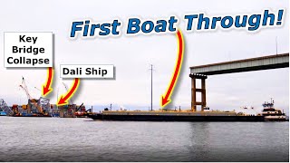 First Boat Goes Through NEW Alt Channel | Key Bridge Collapse |
|
|
|
[#21]
Quoted: That video looks like something out of an Apocalypse movie.
Wow, the youtube account terminated? What was in that video??? |
|
|
|
[#22]
Quoted: .433 PSI per vertical foot of immersion for the hull pressure. Hull Plating to the bilge radius is probably 30 to 38 mm thick, and an AH material grade. Really, unless we are talking about an area of specific reinforcement, I don't think over 19 mm or 3/4" steel is used for the hull plating in large commercial oil tankers and container ships. 80 feet deep is just under 36 psi in sea water. The hull steel is a skin backed by steel structural framework and lots of it. |
|
|
|
[#23]
Quoted: First vessel passes through temporary channel near Key Bridge collapse because towboat captains are used to driving on treacherous two-lanes 
|
|
|
|
[#24]
Quoted: How thick is a hull at the waterline, typically? I would assume between 15mm to 17mm, and AH. Then would transition between 23mm or 25mm to the sheer strake, which would be probably 40mm to 45mm but that material grade is probably an EH40 or similar. |
|
|
|
[#25]
Quoted: Where did that thickness come from? Really, unless we are talking about an area of specific reinforcement, I don't think over 19 mm or 3/4" steel is used for the hull plating in large commercial oil tankers and container ships. 80 feet deep is just under 36 psi in sea water. The hull steel is a skin backed by steel structural framework and lots of it. My material thicknesses come from different classes of container ships that I have either managed the design for or managed the construction/repair of the program. I am currently involved with a new construction LNG container vessel program. The hull thickness that I provided above is towards the upper side of the thickness. Minimal, you may be looking at 17mm to 19mm (AH), but that is on the light side. The pressure you provided above is based upon the SG of the water being at max salinity for the region. My pressure was based upon hydrometer recordings for inclines that I was involved with in Baltimore Harbor, and keeping it lighter. |
|
|
|
[#26]
Quoted: My material thicknesses come from different classes of container ships that I have either managed the design for or managed the construction/repair of the program. I am currently involved with a new construction LNG container vessel program. The hull thickness that I provided above is towards the upper side of the thickness. Minimal, you may be looking at 17mm to 19mm (AH), but that is on the light side. The pressure you provided above is based upon the SG of the water being at max salinity for the region. My pressure was based upon hydrometer recordings for inclines that I was involved with in Baltimore Harbor, and keeping it lighter. Quoted: Quoted: Where did that thickness come from? Really, unless we are talking about an area of specific reinforcement, I don't think over 19 mm or 3/4" steel is used for the hull plating in large commercial oil tankers and container ships. 80 feet deep is just under 36 psi in sea water. The hull steel is a skin backed by steel structural framework and lots of it. My material thicknesses come from different classes of container ships that I have either managed the design for or managed the construction/repair of the program. I am currently involved with a new construction LNG container vessel program. The hull thickness that I provided above is towards the upper side of the thickness. Minimal, you may be looking at 17mm to 19mm (AH), but that is on the light side. The pressure you provided above is based upon the SG of the water being at max salinity for the region. My pressure was based upon hydrometer recordings for inclines that I was involved with in Baltimore Harbor, and keeping it lighter. Not quite a capn Rob moment, but it'll do in a pinch. |
|
|
|
[#27]
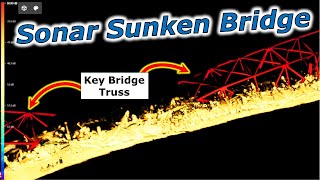 Shocking NAVY Sonar Images Baltimore Bridge Collapse |
|
|
|
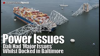
[#28]
Eye Witness Speaks of Dali Power Issues BEFORE Crash
 Eye Witness Speaks of Dali Power Issues BEFORE Crash | SY News Ep315 |
|
|
|
[#29]
Governor update on Key Bridge collapse
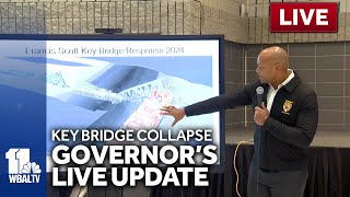 LIVE: Governor provides updates on Key Bridge collapse - wbaltv.com Crews opened a second temporary channel on Tuesday allowing a limited amount of marine traffic to bypass the wreckage of Baltimore's collapsed Francis Scott Key Bridge, which had blocked the vital port's main shipping channel since its destruction one week ago. Work is ongoing to open a third channel that will allow larger vessels to pass through the bottleneck, officials announced at a news conference Tuesday afternoon. The channels are primarily open primarily to vessels that are helping with the cleanup effort, along with some barges and tugs that have been stuck in the Port of Baltimore. A tugboat pushing a fuel barge was the first vessel to use an alternate channel late Monday. It was supplying jet fuel to Delaware's Dover Air Force Base. |
|
|
|
[#30]
Is it just me, or was that bridge a real asshole design?
It was a like truss bridge and a suspension bridge had too much to drink one night. |
|
|
|
[#31]
You got a video without a clickbait title? I'd kinda like to see the sonar without the 'shocking' clickbait title. I despise people who make videos like that and refuse to click them. |
|
|
|
[#32]
Terry Turbin helped construct the Key Bridge and now reflects after collapse
 Terry Turbin helped construct the Key Bridge and now reflects after collapse |
|
|
|
[#33]
Quoted: Governor update on Key Bridge collapse Crews opened a second temporary channel on Tuesday allowing a limited amount of marine traffic to bypass the wreckage of Baltimore's collapsed Francis Scott Key Bridge, which had blocked the vital port's main shipping channel since its destruction one week ago. Work is ongoing to open a third channel that will allow larger vessels to pass through the bottleneck, officials announced at a news conference Tuesday afternoon. The channels are primarily open primarily to vessels that are helping with the cleanup effort, along with some barges and tugs that have been stuck in the Port of Baltimore. A tugboat pushing a fuel barge was the first vessel to use an alternate channel late Monday. It was supplying jet fuel to Delaware's Dover Air Force Base. Governor "Empty Suit" doing what he does best, grandstanding on TV. |
|
|
|
[#34]
One of my guys was sending me pics today. It was a little rough out there today, too. |
|
|
|
[#35]
Quoted: https://www.ar15.com/media/mediaFiles/141830/IMG-1488_jpg-3177406.JPGhttps://www.ar15.com/media/mediaFiles/141830/IMG-1496_jpg-3177407.JPGhttps://www.ar15.com/media/mediaFiles/141830/IMG-1477_jpg-3177408.JPG One of my guys was sending me pics today. It was a little rough out there today, too. @TurkeyLeg Great pic. What does your man do? |
|
|
|
[#36]
Quoted: My material thicknesses come from different classes of container ships that I have either managed the design for or managed the construction/repair of the program. I am currently involved with a new construction LNG container vessel program. The hull thickness that I provided above is towards the upper side of the thickness. Minimal, you may be looking at 17mm to 19mm (AH), but that is on the light side. The pressure you provided above is based upon the SG of the water being at max salinity for the region. My pressure was based upon hydrometer recordings for inclines that I was involved with in Baltimore Harbor, and keeping it lighter. @mrhiggs, @capnrob, You have a new member to your club it seems. |
|
|
|
[#37]
Quoted: @TurkeyLeg Great pic. What does your man do? Unfortunately, I cant comment on why my guys were there for several reasons. We have customers on all sides of this. Our guys have literally been on every boat in that harbor right now EXCEPT the Dali. It doesnt matter much anyway -- as of right now, there isnt anything worthwhile to report that everyone in the marine industry doesnt already know. I can say this -- the middle of last week it was made very clear to all the marine construction and salvage outfits from Norfolk to Jersey that if cranes and salvage equipment could be provided quickly, they would be paid to be onsite, even if they werent ready for them yet. Seaward out of Norfolk and DonJon up in Jersey beat feet up there last week and are standing by. Crofton sent a crane and the floaters like Dann Marine might be hanging out to get something as well. The companies that do alot of ship docking (Moran, McAllister, etc..) are probably licking their eyebrows right now. Ive already heard rumblings from other municipalities about additional tug assist requirements in the future. Edit to add: Additional tug assists for places that have bridges, I mean. Not really as big a deal for Norfolk due to the CBBT, MMBT and HRBT but there are a few smaller ports that will end up with a huge tug presence before the decade is out. |
|
|
|
[#38]
Not the greatest pictures, but I figured maybe the structural engineer types might like to see them. |
|
|
|
[#39]
 Up close to the Baltimore bridge collapse wreckage |
|
|
|
[#40]
 Who knew it was THAT EASY?! |
|
|
|
[#41]
Quoted: Is it just me, or was that bridge a real asshole design? It was a like truss bridge and a suspension bridge had too much to drink one night.  In 1973, Agnew was investigated by the United States Attorney for the District of Maryland on suspicion of criminal conspiracy, bribery, extortion, and tax fraud. Agnew took kickbacks from contractors during his time as Baltimore county executive and governor of Maryland. The payments had continued into his time as vice president. |
|
|
|
[#42]
50,000 ton reporter next to 100,000 ton ship. |
|
|
|
[#43]
So Jan Arden is a CBC reporter now ? |
|
|
|
[#44]
lol |
|
|
|
[#45]
Lol wat |
|
|
|
[#46]
 Luther Heggs in the cinema classic The Ghost and Mr. Chicken. |
|
|
|
[#47]
Quoted: Wow, the youtube account terminated? What was in that video??? I believe it was a video of the Ukrainian attack on the Kerch bridge, going off memory. |
|
|
|
[#48]
Quoted: https://www.ar15.com/media/mediaFiles/141830/IMG-1494_jpg-3177503.JPGhttps://www.ar15.com/media/mediaFiles/141830/IMG-1484_jpg-3177504.JPGhttps://www.ar15.com/media/mediaFiles/141830/IMG-1474_jpg-3177508.JPG Not the greatest pictures, but I figured maybe the structural engineer types might like to see them. I want to see enough photos to get a better idea of the tangle and the sequence of removal. It's looking like I'll need to settle for new photos every several days. |
|
|
|
[#49]
That is some very cool tech! Merging LIDAR above water and Side Scan Sonar below makes a very cool composition so it's clear what is actually going on. |
|
|
|
[#50]
What would the cost savings be had the SOP for transitioning from the harbor to the open water include keeping the 2 harbor tugs engaged with the ship until it cleared the bridge?
|
|
|
 Win a FREE Membership!
Sign up for the ARFCOM weekly newsletter and be entered to win a free ARFCOM membership. One new winner* is announced every week!
You will receive an email every Friday morning featuring the latest chatter from the hottest topics, breaking news surrounding legislation, as well as exclusive deals only available to ARFCOM email subscribers.

AR15.COM is the world's largest firearm community and is a gathering place for firearm enthusiasts of all types.
From hunters and military members, to competition shooters and general firearm enthusiasts, we welcome anyone who values and respects the way of the firearm.

Subscribe to our monthly Newsletter to receive firearm news, product discounts from your favorite Industry Partners, and more.
Copyright © 1996-2024 AR15.COM LLC. All Rights Reserved.
Any use of this content without express written consent is prohibited.
AR15.Com reserves the right to overwrite or replace any affiliate, commercial, or monetizable links, posted by users, with our own.


