|
[#1]
So it appears that it could shift west and hit Destin area. I'm not too excited about it, but I don't think I'm going anywhere.
|
|
|
|
[#2]
Quoted: So it appears that it could shift west and hit Destin area. I'm not too excited about it, but I don't think I'm going anywhere. That area seems to be the catcher's mitt for the bulk of hurricanes hitting Florida in the past several years. |
|
|
|
[#3]
Quoted: That area seems to be the catcher's mitt for the bulk of hurricanes hitting Florida in the past several years. Sure does seem that way. |
|
|
|
[#4]
I am ok with a western slide.....
|
|
|
|
[#5]
Quoted: I am ok with a western slide..... Same here. Yesterday at noon Tampa was the bullseye. Now it's Apalachicola. Sigh of relief. But things can (and usually do) change when the storm is this far from landfall. Remember Charley in 2004? This...  Turned into this practically overnight... 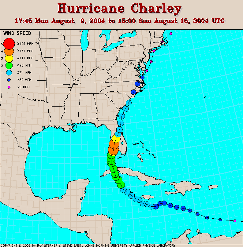 Plenty of people in Punta Gorda failed to prepare and got hammered. |
|
|
|
[#6]
Quoted: Same here. Yesterday at noon Tampa was the bullseye. Now it's Apalachicola. Sigh of relief. But things can (and usually do) change when the storm is this far from landfall. Remember Charley in 2004? This... https://www.wfla.com/wp-content/uploads/sites/71/2019/08/charley-3-days-out.gif Turned into this practically overnight... https://www2.atmos.umd.edu/~stevenb/hurr/04/charley/charley.gif Plenty of people in Punta Gorda failed to prepare and got hammered. We got slapped hard on the east coast to. Caught everyone off guard. |
|
|
|
[#7]
The last few runs of the GFS model seem to be stopping it's westward slide. This is its latest position at landfall
And here are the previous three runs for the same time period at landfall ending with the 12Z run yesterday: 00Z Sunday 18Z Saturday 12Z Saturday The European model still is showing a Tampa Bay landing |
|
|
|
[#8]
Quoted: So it appears that it could shift west and hit Destin area. I'm not too excited about it, but I don't think I'm going anywhere. I don’t know if you live where I think you do but if so, that area has historically gotten freakin hammered by storms. All those pretty blue awnings I just installed on a building out there are going to be making their way to Crestview soon. |
|
|
|
[#9]
What effect does the west end of Cuba have on it? It could scoot right between cuba and Yucatán?
It could do it. |
|
|
|
[#10]
Quoted: What effect does the west end of Cuba have on it? It could scoot right between cuba and Yucatán? It could do it. Not much effect, western Cuba is fairly flat |
|
|
|
[#11]
Quoted: Not much effect, western Cuba is fairly flat Quoted: Quoted: What effect does the west end of Cuba have on it? It could scoot right between cuba and Yucatán? It could do it. Not much effect, western Cuba is fairly flat All I know is that western Cubs is where cohibas are delivered from god. |
|
|
|
[#12]
Quoted: What effect does the west end of Cuba have on it? It could scoot right between cuba and Yucatán? It could do it. Interaction with that part would have a minimal effect on a cat 3 or 4. If it shoots through the straits it means it’s following the western track of the GFS. Latest recon said it still has not got its shit together yet. |
|
|
|
[#13]
Quoted: The last few runs of the GFS model seem to be stopping it's westward slide. This is its latest position at landfall https://www.ar15.com/media/mediaFiles/310516/GFS1_jpg-2538531.JPG And here are the previous three runs for the same time period at landfall ending with the 12Z run yesterday: 00Z Sunday https://www.ar15.com/media/mediaFiles/310516/GFS2_jpg-2538538.JPG 18Z Saturday https://www.ar15.com/media/mediaFiles/310516/GFS3_jpg-2538539.JPG 12Z Saturday https://www.ar15.com/media/mediaFiles/310516/GFS4_jpg-2538540.JPG The European model still is showing a Tampa Bay landing https://www.ar15.com/media/mediaFiles/310516/UK1_jpg-2538543.JPG I wonder how much Publix, Walmart etc are paying the Urpeens to keep re-running that model. |
|
|
|
[#14]
Latest update from a weather service
Key Points ?1. There are no significant changes in this advisory. ?2. Landfall is predicted to be north of Tampa, FL as a Category 1 or 2 hurricane Thursday evening. Our Forecast ?Two reconnaissance planes are currently investigating Ian this morning. Neither is finding any large area of tropical storm force winds, and neither is finding a single, coherent center. However, its appearance in satellite imagery is improving, and we think that Ian will develop a single tight center later today as it moves into a more favorable environment. We have made no significant changes in this advisory. Ian is tracking as predicted, and model guidance has been consistent, with the exception of the American model, which has not performed well with Ian. Model consensus is for a track across western Cuba on Tuesday morning then north to north-northeastward across the eastern Gulf toward the northern Florida Peninsula. Our forecast is in agreement with model consensus, taking Ian inland north of Tampa on Thursday evening. From there, it should turn northward into eastern Georgia, where it will steadily weaken to a remnant low prior to reaching the western Carolinas. Concerning intensity, given Ian's current disorganized state, it may take a little longer for it to reach hurricane strength, but it should become a hurricane within the next 24 hours or so. Ian could become a Category 3 hurricane prior to passing western Cuba. As Ian tracks northward west of Florida on Wednesday and Thursday, it should begin to feel the effects of strong southwesterly winds aloft. This wind shear, combined with dry air intrusion from the west, should lead to weakening prior to landfall in Florida. Note that Ian could make its final landfall anywhere from the Big Bend area of the eastern Florida Panhandle to as far south as Ft. Myers. The farther north Ian makes landfall, the weaker it will be. If Ian turns more sharply northeastward and makes landfall south of the Tampa area, then it would arrive earlier than Thursday evening and it would likely be stronger. |
|
|
|
[#15]
Quoted: Latest update from a weather service Key Points ?1. There are no significant changes in this advisory. ?2. Landfall is predicted to be north of Tampa, FL as a Category 1 or 2 hurricane Thursday evening. Our Forecast ?Two reconnaissance planes are currently investigating Ian this morning. Neither is finding any large area of tropical storm force winds, and neither is finding a single, coherent center. However, its appearance in satellite imagery is improving, and we think that Ian will develop a single tight center later today as it moves into a more favorable environment. We have made no significant changes in this advisory. Ian is tracking as predicted, and model guidance has been consistent, with the exception of the American model, which has not performed well with Ian. Model consensus is for a track across western Cuba on Tuesday morning then north to north-northeastward across the eastern Gulf toward the northern Florida Peninsula. Our forecast is in agreement with model consensus, taking Ian inland north of Tampa on Thursday evening. From there, it should turn northward into eastern Georgia, where it will steadily weaken to a remnant low prior to reaching the western Carolinas. Concerning intensity, given Ian's current disorganized state, it may take a little longer for it to reach hurricane strength, but it should become a hurricane within the next 24 hours or so. Ian could become a Category 3 hurricane prior to passing western Cuba. As Ian tracks northward west of Florida on Wednesday and Thursday, it should begin to feel the effects of strong southwesterly winds aloft. This wind shear, combined with dry air intrusion from the west, should lead to weakening prior to landfall in Florida. Note that Ian could make its final landfall anywhere from the Big Bend area of the eastern Florida Panhandle to as far south as Ft. Myers. The farther north Ian makes landfall, the weaker it will be. If Ian turns more sharply northeastward and makes landfall south of the Tampa area, then it would arrive earlier than Thursday evening and it would likely be stronger. IOW wind shear could very well blow it apart and turn it in to a nothingburger in short order |
|
|
|
[#16]
West FL is going to suffer no matter where Ian lands, it could be worse even if it travels farther north and weakens just due to the storm surge and heavy rain all up the coast.
|
|
|
|
[#17]
Quoted: We got slapped hard on the east coast to. Caught everyone off guard. Also hit late at night. Which may increase your anxiety level, it certainly did mine. |
|
|
|
[#18]
Posted this in the $50 or less thread, but figured I’d post it here too for the folks who lose power with every storm…
This little $13.99 drill pump - is for anyone who’s ever had to get out in the middle of a storm (or) hurricane to drain your pool to keep it from overflowing (after your pool pump has lost power). It’s saved my ass during 3 different hurricanes. NOTE: I’ve tried 3 different drill pump brands and this is the only one that actually worked and didn’t burn up / break like the other 2 from Chinese companies. Linky here: All it takes is this pump, a cordless drill (I used ryobi), a short 12-ft or less long garden hose, along with a long hose to drain the water. Don’t forget a zip tie or your hands gonna get tired ProTip: prime the pump first by submerging it in water for a few secs, otherwise it is almost impossible to get it drawing… |
|
|
|
[#19]
It still hasn’t started its turn north. Latest hurricane hunter passes show it’s still sliding west.
|
|
|
|
[#20]
Well, we are boned.... the four horsemen of the hurricane are coming my my area...
 https://www.news-press.com/story/weather/hurricane/2022/09/25/where-jim-cantore-weather-channel-reporting-florida-ian-gulf-of-mexico-clearwater-beach/8113804001/ |
|
|
|
[#21]
|
|
|
|
[#22]
Stop. Moving. West.
|
|
|
|
[#23]
Quoted: Stop. Moving. West. Comparing the point of landfall between the last 2 tracks, it did stop. Makes me wonder if it will start shifting back East soon. I need to fix my chainsaw. Shouldn't have put it off 
|
|
|
|
[#24]
Praying for my NW FL brothers.
|
|
|
|
[#25]
It has turned NW moving at 12mph.
Pressure dropping. It’s FO time. |
|
|
|
[#26]
Quoted: I am ok with a western slide..... |
|
|
|
[#27]
Quoted: We got slapped hard on the east coast to. Caught everyone off guard. Quoted: Quoted: Same here. Yesterday at noon Tampa was the bullseye. Now it's Apalachicola. Sigh of relief. But things can (and usually do) change when the storm is this far from landfall. Remember Charley in 2004? This... https://www.wfla.com/wp-content/uploads/sites/71/2019/08/charley-3-days-out.gif Turned into this practically overnight... https://www2.atmohs.umd.edu/~stevenb/hurr/04/charley/charley.gif Plenty of people in Punta Gorda failed to prepare and got hammered. We got slapped hard on the east coast to. Caught everyone off guard. After seeing trees blown north on one side of I75 and south on the other, I'm still convinced Charlie was actually the world's biggest tornado more than a hurricane. That thing was tight, fast and violent. |
|
|
|
[#28]
I just left my mom's house in the Crestview area a couple days ago. I also have a sister in Tallahassee. I suppose things might be rearranged when I'm back on Thanksgiving. I could never live in Florida or the southeast again. I hate everything about the weather there.
|
|
|
|
[#29]
Quoted: Stop. Moving. West. No no... west is good. Keep er going!!
|
|
|
|
[#30]
Latest GFS model run showing a slide back to the east a little. Now predicting Apalachicola landfall.
|
|
|
|
[#31]
Quoted: After seeing trees blown north on one side of I75 and south on the other, I'm still convinced Charlie was actually the world's biggest tornado more than a hurricane. That thing was tight, fast and violent. Quoted: Quoted: Quoted: Same here. Yesterday at noon Tampa was the bullseye. Now it's Apalachicola. Sigh of relief. But things can (and usually do) change when the storm is this far from landfall. Remember Charley in 2004? This... https://www.wfla.com/wp-content/uploads/sites/71/2019/08/charley-3-days-out.gif Turned into this practically overnight... https://www2.atmohs.umd.edu/~stevenb/hurr/04/charley/charley.gif Plenty of people in Punta Gorda failed to prepare and got hammered. We got slapped hard on the east coast to. Caught everyone off guard. After seeing trees blown north on one side of I75 and south on the other, I'm still convinced Charlie was actually the world's biggest tornado more than a hurricane. That thing was tight, fast and violent. I rode though the Panhandle in 2019 and the damage through there is far worse than what Charlie did. |
|
|
|
[#32]
Quoted: Comparing the point of landfall between the last 2 tracks, it did stop. Makes me wonder if it will start shifting back East soon. I need to fix my chainsaw. Shouldn't have put it off Quoted: Quoted: Stop. Moving. West. Comparing the point of landfall between the last 2 tracks, it did stop. Makes me wonder if it will start shifting back East soon. I need to fix my chainsaw. Shouldn't have put it off For whatever it's worth, Jim Cantore is in Clearwater Beach
|
|
|
|
[#33]
Quoted: For whatever it's worth, Jim Cantore is in Clearwater Beach "CONDITIONS ARE DETERIORATING RAPIDLY!" *Family casually walks by in background* |
|
|
|
[#34]
Jim discovers an over turned trash can, “ Oh the humanity “,
Look at those palms blowing! One will fall any minute. |
|
|
|
[#35]
They have dropped the level of the Lake Kissimmee basin 2 inches in less than 24 hours. That is over 2.3 billion gallons
of water. Hard to fathom isn't it. |
|
|
|
[#36]
|
|
|
|
[#37]
Quoted: They have dropped the level of the Lake Kissimmee basin 2 inches in less than 24 hours. That is over 2.3 billion gallons of water. Hard to fathom isn't it. Where’d they put it? |
|
|
|
[#38]
Quoted: Where’d they put it? Quoted: Quoted: They have dropped the level of the Lake Kissimmee basin 2 inches in less than 24 hours. That is over 2.3 billion gallons of water. Hard to fathom isn't it. Where’d they put it? Down the river to Lake O |
|
|
|
[#39]
So which model is the one to use. GFS or European or are they the same?
|
|
|
|
[#40]
 i'm not fucking leaving |
|
|
|
[#41]
|
|
|
|
[#42]
Quoted: I don't know if you live where I think you do but if so, that area has historically gotten freakin hammered by storms. All those pretty blue awnings I just installed on a building out there are going to be making their way to Crestview soon. |
|
|
|
[#43]
Quoted: 1p.m. EDT YESTERDAY release https://www.ar15.com/media/mediaFiles/279984/09L_gefs_18z_png-2538860.JPG Today.. https://www.ar15.com/media/mediaFiles/279984/09L_gefs_06z_png-2538863.JPG I wasn’t here for Michael, but the area can’t handle another. I hate to hope it goes east or west, so I pray it doesn’t intensify |
|
|
|
[#44]
12Z GFS:
12Z ICON: Either way, there’s going to be a lot of rain pretty much everywhere in Florida. 
|
|
|
|
[#45]
Good luck to arf brothers in the path. I'm actually boarding a plane to Atlanta in a bit, leaving Thursday evening. I don't think affects should be there by then.
|
|
|
|
[#46]
Sitting here on the beach right in the middle of the bullseye.
Beautiful day! Later in the week, maybe not. |
|
|
|
[#47]
Quoted: I rode though the Panhandle in 2019 and the damage through there is far worse than what Charlie did. A lot of experience with hurricanes in this thread. I'm not down playing anyone elses experience, but I will say that having been through a Cat 5 impact, it really becomes an event that is quite frightening. |
|
|
|
[#48]
|
|
|
|
[#49]
Quoted: A lot of experience with hurricanes in this thread. I'm not down playing anyone elses experience, but I will say that having been through a Cat 5 impact, it really becomes an event that is quite frightening. Saw Miami after Andrew and the 2 things that really struck me were the height of the storm surge water mark on apartment buildings (above 2nd floor level), and the miles of pine trees permanently curved over at 30-45° as seen from a boat. It was sobering. |
|
|
|
[#50]
Quoted: Saw Miami after Andrew and the 2 things that really struck me were the height of the storm surge water mark on apartment buildings (above 2nd floor level), and the miles of pine trees permanently curved over at 30-45° as seen from a boat. It was sobering. In the area where I live the pines and the thin oaks all lean to the south. That is from the wind shifting to coming out of the north as the eye moved ashore and inland. This is a very short video from the area jail security cameras showing what a cat 5 is like. For those that haven't experienced these things, imagine those conditions for a couple of hours.  Bay County Jail camera records audio at height of Cat. 4 Hurricane Michael |
|
|
 Win a FREE Membership!
Sign up for the ARFCOM weekly newsletter and be entered to win a free ARFCOM membership. One new winner* is announced every week!
You will receive an email every Friday morning featuring the latest chatter from the hottest topics, breaking news surrounding legislation, as well as exclusive deals only available to ARFCOM email subscribers.

AR15.COM is the world's largest firearm community and is a gathering place for firearm enthusiasts of all types.
From hunters and military members, to competition shooters and general firearm enthusiasts, we welcome anyone who values and respects the way of the firearm.

Subscribe to our monthly Newsletter to receive firearm news, product discounts from your favorite Industry Partners, and more.
Copyright © 1996-2024 AR15.COM LLC. All Rights Reserved.
Any use of this content without express written consent is prohibited.
AR15.Com reserves the right to overwrite or replace any affiliate, commercial, or monetizable links, posted by users, with our own.


