|
[#1]
USGS video showing fissures 20West, 20East, 16, and 18
https://volcanoes.usgs.gov/observatories/hvo/multimedia_uploads/multimediaFile-2036.mp4 |
|
|
|
[#2]
Quoted:
here's that 2 foot rock in the parking lot. https://i.imgur.com/xi6PqPk.jpg Close view of rock hurled from the Overlook crater during an explosive event last evening. The rock broke apart on impact, and was about 60 cm (24 in) before it hit the ground. The location is a few hundred meters (yards) south of the Overlook crater at the Halema‘uma‘u parking lot. Note the ash covering the parking lot, less than about 1 cm (0.4 in) in thickness. Looks like the beach, not a parking lot. |
|
|
|
[#3]
https://volcanoes.usgs.gov/volcanoes/kilauea/status.html
Wednesday, May 16, 2018, 2:35 PM HST KLAUEA INFORMATION STATEMENT Strong earthquakes within the summit of Klauea Volcano continue in response to ongoing deflation and lava column drop. As of the afternoon of May 16, the floor of Klauea caldera has dropped approximately 3 feet (90 cm). This movement is stressing faults around the caldera of Kilauea, causing them to move and resulting in strong earthquakes of up to magnitude 4.4 thus far. Employees at the Hawaiian Volcano Observatory, Hawai`i Volcanoes National Park and nearby residents are reporting frequent ground shaking and damage to roads and buildings. Hawaii County Police reports cracks across Highway 11 between mile markers 28 and 29. Although these are passable, motorists are urged to use caution. As deflation continues, strong earthquakes in the area around Kilauea Volcano's summit are expected to continue and may become more frequent. Areas further from these earthquakes may feel some ground motion as well, but much less severe. The shallow depths of these earthquakes make them more damaging in the immediate vicinity of the epicenter, and individuals need to take precautions to minimize damage from the shaking, including the removal of unstable items from walls and shelves. Steep slopes should be avoided as they may become destabilized during strong earthquakes. |
|
|
|
[#4]
|
|
|
|
[#5]
Sounds like it just erupted again
|
|
|
|
[#6]
Quoted:
Sounds like it just erupted again 
|
|
|
|
[#7]
My buddy's on a flight there as I type for his wedding, not on that island though. Wonder if it'll effect his stay.
|
|
|
|
[#8]
Issued: Thursday, May 17, 2018, 6:33 AM HST
Source: Hawaiian Volcano Observatory Notice Number: Location: N 19 deg 25 min W 155 deg 17 min Elevation: 4091 ft (1247 m) Area: Hawaii Volcanic Activity Summary: At about 0415 this morning, an explosion from the Overlook vent within Halemaumau crater at Kilauea Volcano's summit produced a volcanic cloud that reaches as high as 30,000 ft asl and drifted northeast. Continued emissions from the crater are reaching as high as 12,000 ft asl. At any time, activity may again become more explosive, increasing the intensity of ash production and producing ballistic projectiles near the vent. Resource on volcanic ash hazards: https://volcanoes.usgs.gov/volcanic_ash/ Resource on vog: https://vog.ivhhn.org/ Current NWS information on ashfall: http://www.prh.noaa.gov/hnl/watchwarn/ Recent Observations: [Volcanic cloud height] up to 30,000 ft asl [Other volcanic cloud information] Drifting generally northeast Hazard Analysis: [Ash cloud] The ashcloud is drifting downwind to the northeast. [Ashfall] Ashfall has been reported in Volcanoes National Park, and may occur further downwind. [Other hazards] Ballistic projectiles may be produced should steam-driven explosions occur. Impacts will be limited to an area around Halemaumau. [Volcanic gas] Vog or volcanic air pollution produced by volcanic gas has been reported in Pahala. Remarks: Photos of this activity may be found here: https://volcanoes.usgs.gov/volcanoes/kilauea/kilauea_multimedia_15.html |
|
|
|
[#9]
Bump.
It may be fo time in Hawaii. |
|
|
|
[#10]
Bump. Hate to see this at my home away from home.
|
|
|
|
[#11]
|
|
|
|
[#12]
|
|
|
|
[#13]
Quoted:
My buddy's on a flight there as I type for his wedding, not on that island though. Wonder if it'll effect his stay. |
|
|
|
[#14]
What's the state fish of Hawaii?
|
|
|
|
[#15]
Quoted:
What's the state fish of Hawaii? |
|
|
|
[#16]
ha. ash on the window. That was a decent sized one.
Fissure 17 is still active but has slowed down a lot and the lava flow basically hasn't moved. The ground is in motion in some spots over there... check this picture of Nohea Street out. 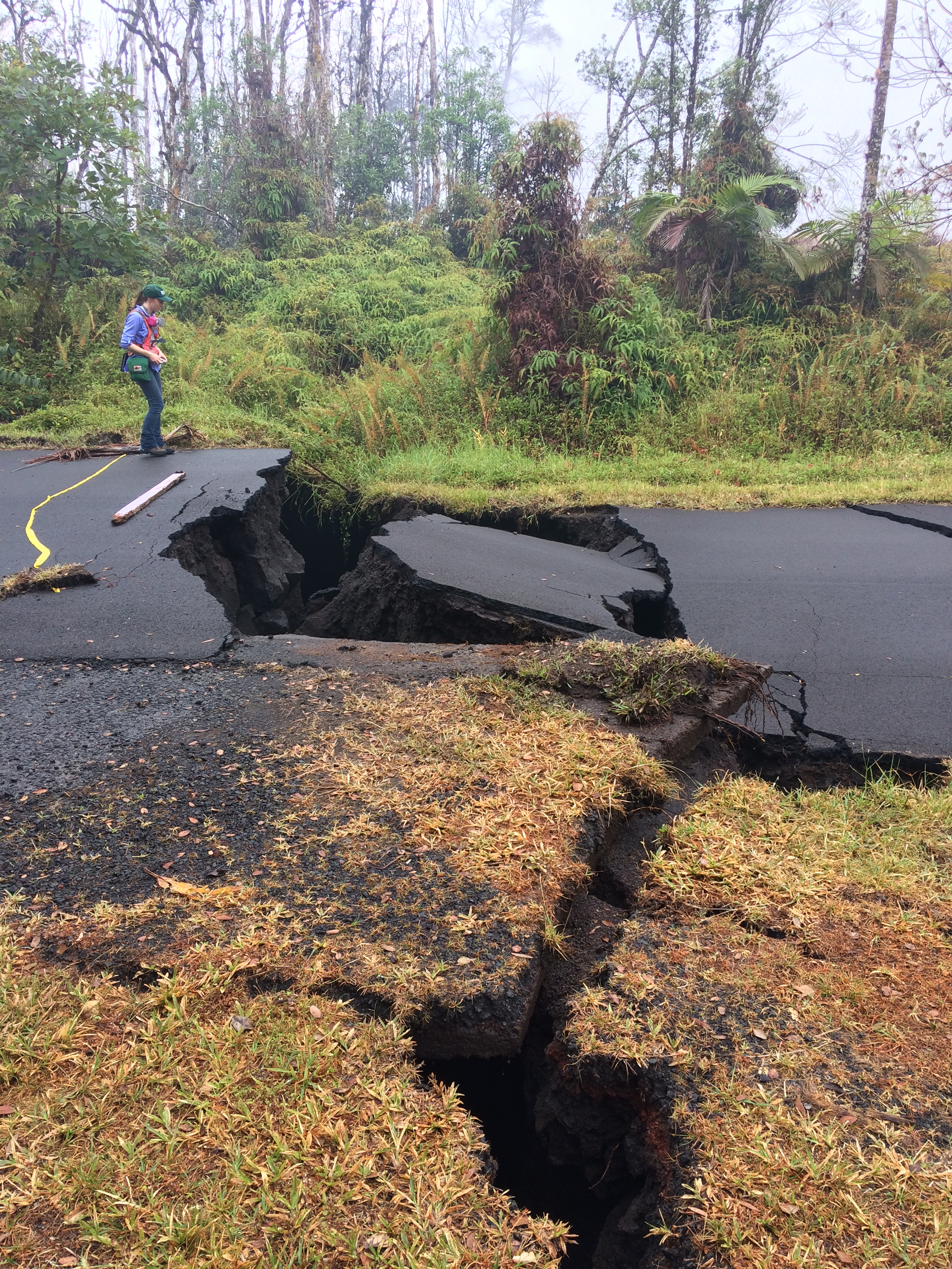
|
|
|
|
[#17]
Quoted:
Humuhumunukunukuapua'a Quoted:
Quoted:
What's the state fish of Hawaii? "Fish that snorts like a pig" |
|
|
|
[#18]
Quoted:
ha. ash on the window. That was a decent sized one. Fissure 17 is still active but has slowed down a lot and the lava flow basically hasn't moved. The ground is in motion in some spots over there... check this picture of Nohea Street out. https://volcanoes.usgs.gov/observatories/hvo/multimedia_uploads/multimediaFile-2040.jpg |
|
|
|
[#19]
Quoted:
ha. ash on the window. That was a decent sized one. Fissure 17 is still active but has slowed down a lot and the lava flow basically hasn't moved. The ground is in motion in some spots over there... check this picture of Nohea Street out. https://volcanoes.usgs.gov/observatories/hvo/multimedia_uploads/multimediaFile-2040.jpg |
|
|
|
[#20]
Quoted:
What's the state fish of Hawaii? 
|
|
|
|
[#21]
Quoted:
So what's more likely at this point: that it's all settling down or that it's building pressure to pop soon? But the ground subsiding like in that photo can be an indicator that magma has left the area under ground... leaving a void... which then gets filled in by the ground falling into it... hence the subsidence. That would be a good thing. The magma wouldn't be under you any more. Or it could be magma forcing things open to provide a path for it to release pressure by coming up to the surface... Only time will tell. |
|
|
|
[#22]
What's the worst case for this going forward, excluding 0.1% likelihood extremes?
|
|
|
|
[#23]
Quoted:
What's the state fish of Hawaii? |
|
|
|
[#24]
Quoted:
What's the worst case for this going forward, excluding 0.1% likelihood extremes? |
|
|
|
[#25]
worst likely case.
Multiple fissures become active and produce lava for Months or more. A new ridge is created looking much like the old ridge that follows the same general path but is just to the south of the current line of fissures. Lava flows from this covering the area as well as areas North East and South East which are both directly in the paths the lava would take to the sea. Lava cuts the coast roads and people West who should have already evacuated... but who probably haven't... have to be rescued via helicopter... helicopters that might not be able to fly due to ash from the main crater. Speaking of the main crater over at Kilauea... it continues erupting ash and throwing rocks significant distances necessitating abandoning the HVO buildings and housing developments close to it. Ash falls over the South Western portion of the island making flying in the area impossible. |
|
|
|
[#26]
Quoted:
Here is a simplistic overview of what I was thinking. |
|
|
|
[#27]
the current active fissure(17) which has been active for 3 days now.
 And a mile and a half to the South East... the front of the flow that's coming from that fissure. 
|
|
|
|
[#28]
@Master_of_Orion
Thank you for the time and effort you have put into this thread, and to the other contributors such as @realwar Probably one of the most informative and interesting threads in GD for a while IMO. I know things are probably pretty rough for those directly affected and they have our heartfelt bets wishes. Please keep us updated. |
|
|
|
[#29]
Quoted:
@Master_of_Orion Thank you for the time and effort you have put into this thread, and to the other contributors such as @realwar Probably one of the most informative and interesting threads in GD for a while IMO. I know things are probably pretty rough for those directly affected and they have our heartfelt bets wishes. Please keep us updated. |
|
|
|
[#30]
Quoted:
@Master_of_Orion Thank you for the time and effort you have put into this thread, and to the other contributors such as @realwar Probably one of the most informative and interesting threads in GD for a while IMO. I know things are probably pretty rough for those directly affected and they have our heartfelt bets wishes. Please keep us updated. |
|
|
|
[#31]
Quoted:
Yeah when this whole thing started I looked at the news coverage... and had 1 major question... "But where precisely is the lava erupting?" ... since no maps were forthcoming on the first day... I decided to do it myself. For myself... but also for the people there who probably evacuated and had no idea if their house was still standing or not. I've been sharing the map and pictures I find on twitter... For about 3-4 days no maps were available of where the fissures were and which houses were gone or not. And then maps that were out of date by 20-24 hours or flat out wrong started showing up... So I've been continuing. Quoted:
Quoted:
@Master_of_Orion Thank you for the time and effort you have put into this thread, and to the other contributors such as @realwar Probably one of the most informative and interesting threads in GD for a while IMO. I know things are probably pretty rough for those directly affected and they have our heartfelt bets wishes. Please keep us updated. I salute you. 
|
|
|
|
[#32]
I'm on Oahu, I hope the ash cloud smothers the west coast Libtard so upset about global climate change. One Libtard unfriended me because I said human industrial plants don't cause climate change mother fucking nature does.
|
|
|
|
[#33]
Morning update:
 Hawaii Eruption Update, 11 am Conference Call (May 17, 2018) |
|
|
|
[#34]
Quoted:
@Master_of_Orion Thank you for the time and effort you have put into this thread, and to the other contributors such as @realwar Probably one of the most informative and interesting threads in GD for a while IMO. I know things are probably pretty rough for those directly affected and they have our heartfelt bets wishes. Please keep us updated. Pretty amazing watching Mother Nature |
|
|
|
[#35]
old fissures starting back up... things don't look good for the subdivision. Guessing this is F7 or maybe F14.
 most recent map for reference. 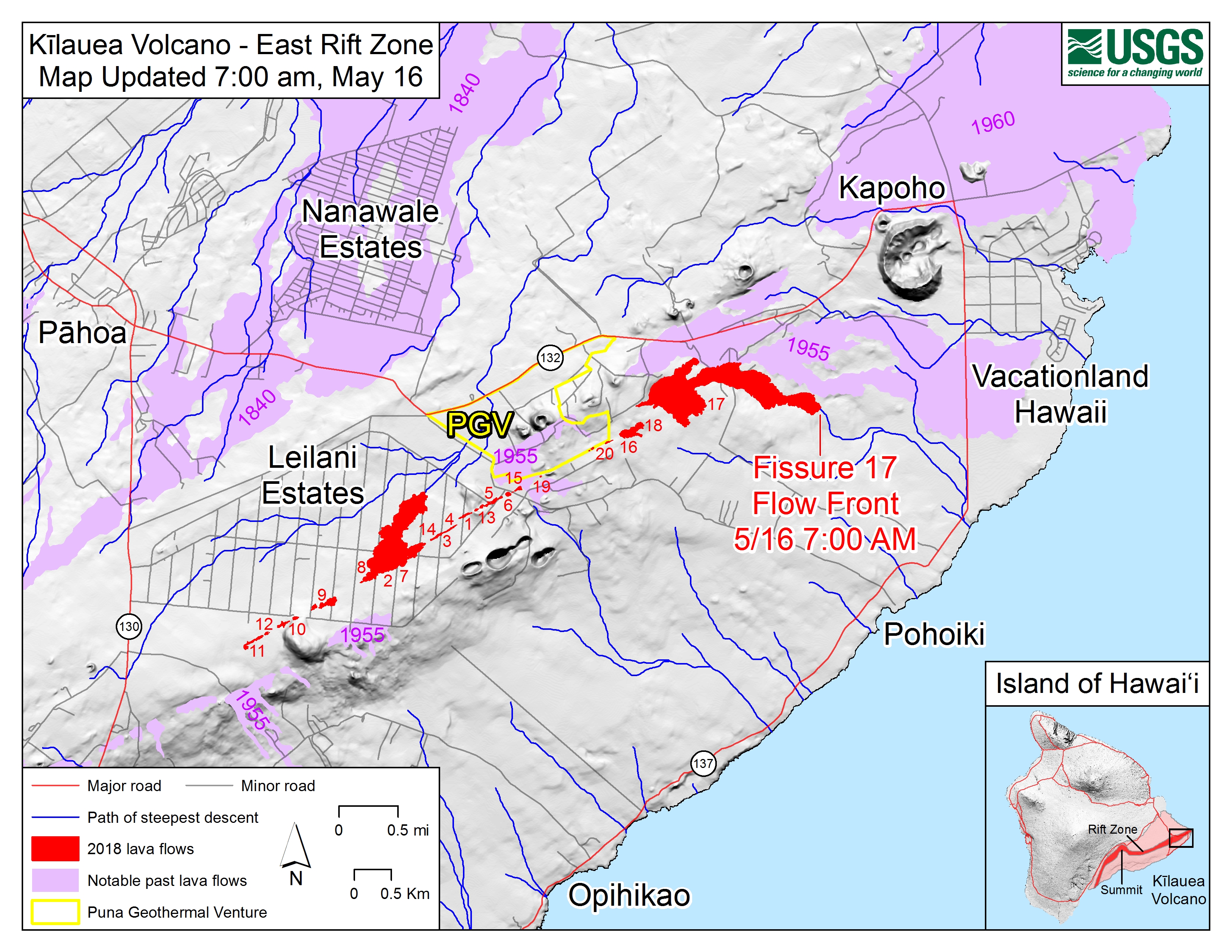
|
|
|
|
[#36]
Quoted:
old fissures starting back up... things don't look good for the subdivision. Guessing this is F7 or maybe F14.  
|
|
|
|
[#37]
.....
|
|
|
|
[#38]
Apparently it's fissure 21. Opened up under one of the earlier flows from Fissure 7. It's a little hard to tell from the one good picture I have of it... it's either running directly across Hookupu st. or is just to the West of it... talking a matter of feet here. Where the fissure exactly is though doesn't matter too much... because a lava flow has started from it. it's adding to the lava that was already across Hookupu...
Here's that one good picture. 
|
|
|
|
[#39]
https://volcanoes.usgs.gov/volcanoes/kilauea/status.html
An area 50-100 yards wide, parallel to and north of the line of fissures between Highway 130 and Lanipuna Gardens, has dropped slightly. This long depression is currently being filled by pahoehoe lava flows from fissures 20 and 21. That's very not good. There are a lot of houses between fissures 20 and 21. |
|
|
|
[#40]
video.
https://www.facebook.com/wxchasing/videos/645037942494506/ This apparently is pahoehoe (the faster more liquid type of lava) This could rather quickly spread pretty far. |
|
|
|
[#41]
Umm.. memory says ash over 18k feet starts to get picked up by prevailing upper air currents and starts to be distributed globally ... ?
Obviously the amount of ash matters but longevity could also have an affect down the road. So.. at the same time it spews out massive quantities of greenhouse gasses to push global warming over the edge...it blocks the sun with suspended ash and a cooling trend starts. The libatards are not going to know what to say ! |
|
|
|
[#42]
So some info I've gleaned from watching this all. This "rift zone" has had eruptions before... and even after eruptions cease lava that didn't make it out stay's put... deep under ground... just sitting there... slowly cooling. Key word being slowly. And that's one reason the Geo thermal plant is there... to take advantage of the heat from the magma that was still present in the area.
So... the lava flows thus far have been rather slow moving and mostly A'a. That's the type of lava that hardens all sharp and spikey... so named from the sound you would make if you walked over it barefoot... but I digress. These flows have likely been the old magma getting pushed out of the system. Now we've got 2 flows... one from 20 and one from 21. Both pahoehoe. This is ... and this is just my guess... probably the first of the fresh new lava being erupted. |
|
|
|
[#43]
Quoted:
So some info I've gleaned from watching this all. This "rift zone" has had eruptions before... and even after eruptions cease lava that didn't make it out stay's put... deep under ground... just sitting there... slowly cooling. Key word being slowly. And that's one reason the Geo thermal plant is there... to take advantage of the heat from the magma that was still present in the area. So... the lava flows thus far have been rather slow moving and mostly A'a. That's the type of lava that hardens all sharp and spikey... so named from the sound you would make if you walked over it barefoot... but I digress. These flows have likely been the old magma getting pushed out of the system. Now we've got 2 flows... one from 20 and one from 21. Both pahoehoe. This is ... and this is just my guess... probably the first of the fresh new lava being erupted. |
|
|
|
[#44]
some small ground level pics for 21 from earlier in the day.
 
 
|
|
|
|
[#45]
Is it me or does this eruption look like it is getting worse and not subsiding?
|
|
|
|
[#46]
That shot of the lava creeping up the highway is spooky.
|
|
|
|
[#47]
Quoted: Pig faced triggerfish http://hiphotos.baidu.com/%D4%C6%B3%C7%CD%FC%D3%C7%B2%DD/pic/item/ad4db348359e6186d0c86a7f.jpg 
|
|
|
|
[#48]
Quoted:
For magma chambers they use the shocks from earthquakes, no need for a thumper. There's also a system that uses lightning. |
|
|
|
[#49]
Quoted:
Is it me or does this eruption look like it is getting worse and not subsiding? They were saying the magma coming out was old a'a and it was being pushed out by newer, hotter pahoehoe. And that appears to be exactly what's happening. I think there's a ways to go with this yet. |
|
|
|
[#50]
|
|
|
 Win a FREE Membership!
Sign up for the ARFCOM weekly newsletter and be entered to win a free ARFCOM membership. One new winner* is announced every week!
You will receive an email every Friday morning featuring the latest chatter from the hottest topics, breaking news surrounding legislation, as well as exclusive deals only available to ARFCOM email subscribers.

AR15.COM is the world's largest firearm community and is a gathering place for firearm enthusiasts of all types.
From hunters and military members, to competition shooters and general firearm enthusiasts, we welcome anyone who values and respects the way of the firearm.

Subscribe to our monthly Newsletter to receive firearm news, product discounts from your favorite Industry Partners, and more.
Copyright © 1996-2024 AR15.COM LLC. All Rights Reserved.
Any use of this content without express written consent is prohibited.
AR15.Com reserves the right to overwrite or replace any affiliate, commercial, or monetizable links, posted by users, with our own.


