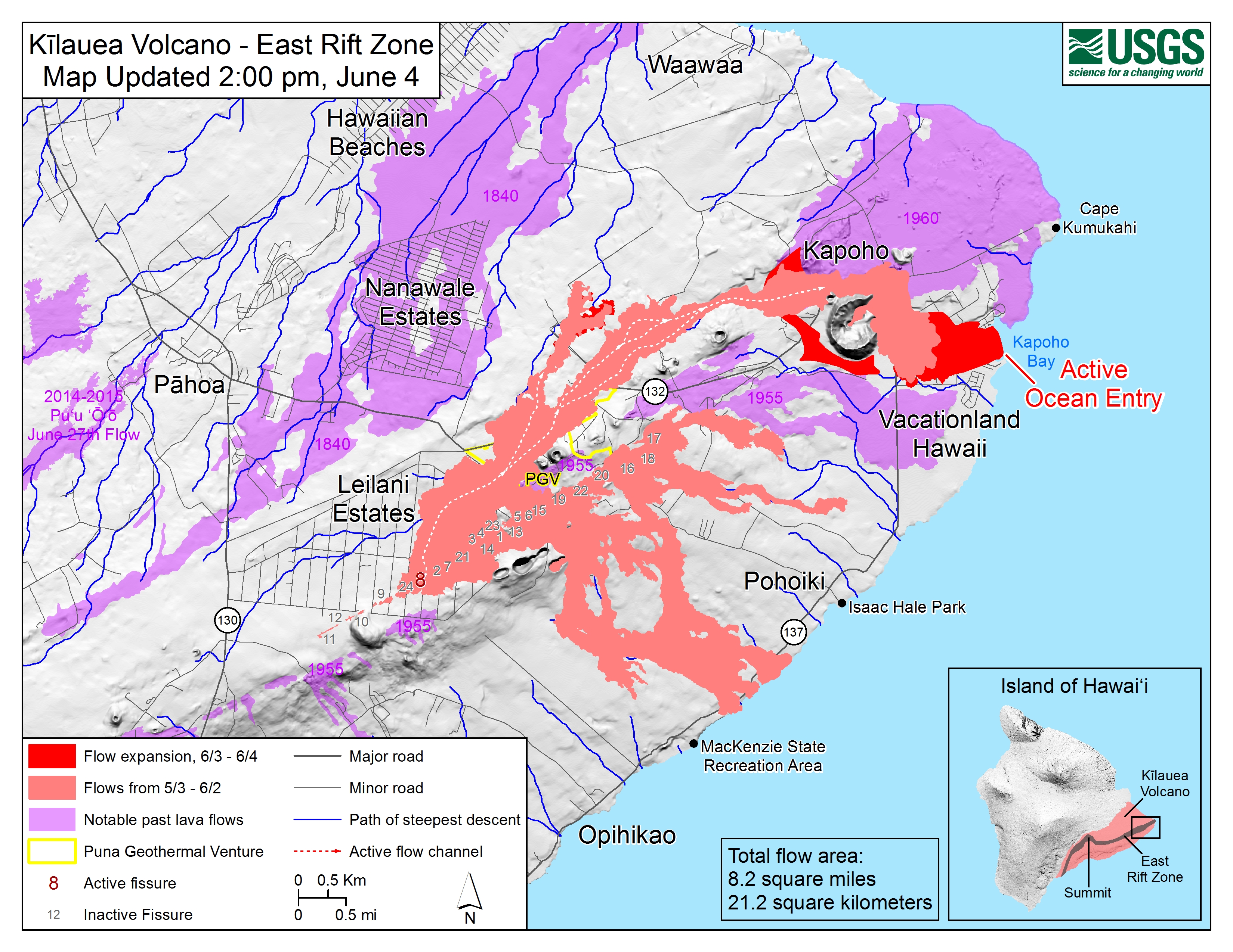
|
[#1]
This animated GIF shows a sequence of radar amplitude images that were acquired by the Italian Space Agency's Cosmo-SkyMed satellite system. The images illustrate changes to the caldera area of Klauea Volcano that occurred between May 5 and June 2 at 6:00 p.m. HST. The satellite transmits a radar signal at the surface and measures the strength of the return, with bright areas indicating a strong return and dark areas a weak return. Strong returns indicate rough surfaces or slopes that point back at the radar, while weak returns come from smooth surfaces or slopes angled away from the radar. Over time, expansion of the summit eruptive vent within Halema'uma'u crater and the widening of Halema'uma'u itself are clear. The last image in the sequence, from June 2, shows the development of several cracks outside Halema'uma'u (previously seen in UAS footage of the crater) and inward slumping of a large portion of the western crater rim. The west side of Halema'uma'u is clearly unstable, and it is possible that rockfalls and continued slumping will occur in the future. 
|
|
|
|
[#2]
You can see it now!! Look at the subsidence on the right side of the bottom photo. Also, notice lack of gasses being put off.
5/31 
6/4 
|
|
|
|
[#3]

|
|
|
|
[#4]

|
|
|
|
[#5]
 The Three Suns - "Volcano" |
|
|
|
[#6]
Ocean doesn’t seem to be slowing it down at all...
|
|
|
|
[#7]
 Earthquakes, Explosions Damage Hawaii Volcanoes National Park (Jun. 4, 2018) |
|
|
|
[#8]
Woah! this new break out south came out of nowhere. I was aware of the emerging one north... but I've seen no overflights showing the south side.
|
|
|
|
[#9]
 Kapoho Lava Update, 11 am USGS Conference Call (June 4, 2018) |
|
|
|
[#10]
|
|
|
|
[#11]
|
|
|
|
[#12]
Pele isn't done.

|
|
|
|
[#13]
look how fast that stuff is flowing from the fissure
|
|
|
|
[#14]
Quoted:
look how fast that stuff is flowing from the fissure Don't want to live in HI, because I'm a snow guy. But *Butthead voice* Syrupy and copious lava is cool... |
|
|
|
[#15]
Wonder what it will look like in the morning?

|
|
|
|
[#16]
|
|
|
|
[#17]
Quoted:
What is wrong with simply letting them take their chances where they are? They know the risk and have accepted the challenge. Leave them alone. |
|
|
|
[#18]
Quoted:
Wonder what it will look like in the morning? |
|
|
|
[#19]
Edit.
|
|
|
|
[#20]
Quoted:
Oh, I agree. If they want to sit there and risk incineration...let them. I was just reporting the fact that another state has decided mandatory evacuation is within their purview. Katrina style gun confiscations next? Quoted:
Quoted:
What is wrong with simply letting them take their chances where they are? They know the risk and have accepted the challenge. Leave them alone. |
|
|
|
[#21]
Quoted:
I don't think forced evacuations are unique to Hawaii. |
|
|
|
[#22]
Quoted:
I don't think forced evacuations are unique to Hawaii. I know most will have friends that will take them in |
|
|
|
[#23]
Fox News is reporting "hundreds" of homes destroyed overnight (just heard it on the radio so I don't have a link).
|
|
|
|
[#24]
Quoted:
Fox News is reporting "hundreds" of homes destroyed overnight (just heard it on the radio so I don't have a link). Dots are flow front 
|
|
|
|
[#25]
Quoted: Yeah it plowed right through a community.. Dots are flow front https://c2.staticflickr.com/2/1742/42596734601_90187f80be_o.jpg |
|
|
|
[#26]
Quoted:
Fox News is reporting "hundreds" of homes destroyed overnight (just heard it on the radio so I don't have a link). https://www.openstreetmap.org/relation/166563#map=14/19.4837/-154.8465 The gray/pink speckled areas is the up to date flow. |
|
|
|
[#27]
Quoted: Yeah it plowed right through a community.. Dots are flow front https://c2.staticflickr.com/2/1742/42596734601_90187f80be_o.jpg |
|
|
|
[#28]
Quoted: Yeah it plowed right through a community.. Dots are flow front https://c2.staticflickr.com/2/1742/42596734601_90187f80be_o.jpg |
|
|
|
[#29]
Quoted: You mean where the flow is projected to go? 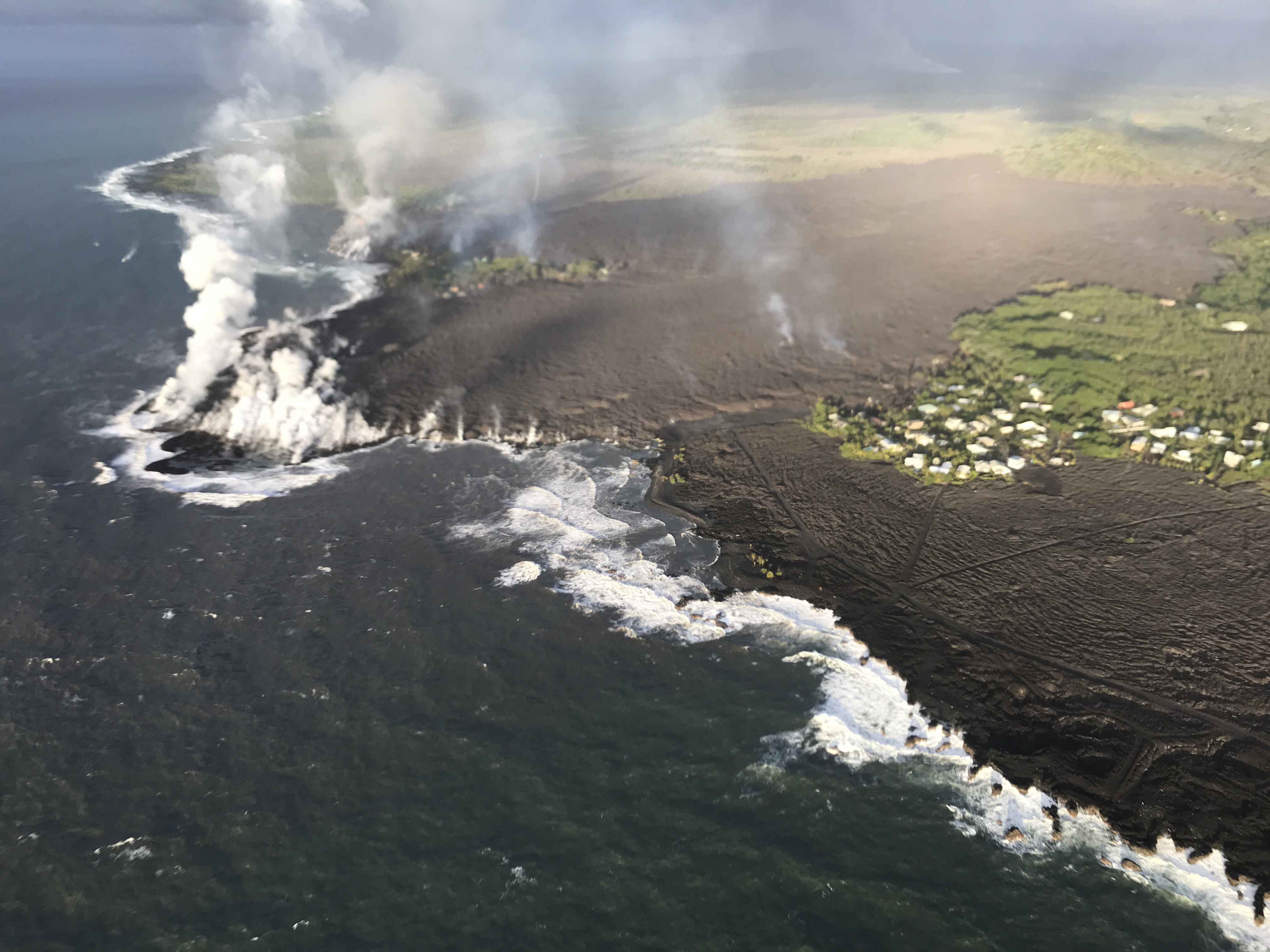
|
|
|
|
[#30]


|
|
|
|
[#31]
Is fissure 8 still as active as it was before?
|
|
|
|
[#32]
Quoted:
Is fissure 8 still as active as it was before? This image will update to the latest image every time you refresh or reopen the thread. 
|
|
|
|
[#33]
Quoted:
Is fissure 8 still as active as it was before? Quoted:
Is fissure 8 still as active as it was before? from USGS FB
The fissure 8 lava fountain height has diminished. Previously, fountain heights reached a sustained 260 ft. During the overnight hours of June 4-5, fluctuating heights were measured at about 100 to 160 ft. The fountain is partially obscured by a cone built by lava spatter, which is about 115 ft high |
|
|
|
[#34]
|
|
|
|
[#35]
More summit subsidence overnight to.. a lot of movement. It could just as much subside to a point and stay that way as much as it could clear its throat.
5/31
6/4
6/5 
Animated it for fun... You can see the whole caldera sinking, not just the crater. 
|
|
|
|
[#36]
Dang. That was a lot of houses - and that entire little bay - wiped out by the flow overnight.
|
|
|
|
[#37]
Quoted:
yes still pumping out lava. This image will update to the latest image every time you refresh or reopen the thread. https://volcanoes.usgs.gov/observatories/hvo/cams/PGcam/images/M.jpg Quoted:
Quoted:
Is fissure 8 still as active as it was before? This image will update to the latest image every time you refresh or reopen the thread. https://volcanoes.usgs.gov/observatories/hvo/cams/PGcam/images/M.jpg |
|
|
|
[#38]
Quoted: Jesus... That whole community and bay were just erased.  Hundreds of homes destroyed overnight, Vacationland and Kapoho Beach Lots inundated |
|
|
|
[#39]
Quoted:
No I think until they update the map itself they just put dots on the leading edge more often.. That is old flow on the bottom right, but you can see the edge of the new flow jives with the dots. https://volcanoes.usgs.gov/observatories/hvo/multimedia_uploads/multimediaFile-2176.jpg Quoted:
Quoted: You mean where the flow is projected to go? https://volcanoes.usgs.gov/observatories/hvo/multimedia_uploads/multimediaFile-2176.jpg |
|
|
|
[#40]
So if you buy a beach front property, are the boundary lines to the ocean? Or are they a set amount of feet off the water, or a perimeter like a normal property?
|
|
|
|
[#41]
Quoted:
So if you buy a beach front property, are the boundary lines to the ocean? Or are they a set amount of feet off the water, or a perimeter like a normal property? |
|
|
|
[#42]
Quoted:
IIRC you don't own the new land. |
|
|
|
[#43]
Quoted:
So if you buy a beach front property, are the boundary lines to the ocean? Or are they a set amount of feet off the water, or a perimeter like a normal property? The supreme court decided it in 1977 and said the state owns all new land. State by Kobayashi v. Zimring |
|
|
|
[#44]
 Hawaii Volcano Eruption - 11 am USGS Conference Call (Jun. 5, 2018)  Hawaii Volcano Eruption Update - Tuesday at Noon (June 5, 2018) |
|
|
|
[#45]
Oh hey USGS set up an actual live stream at the summit.
 Live Stream - Kilauea Volcano |
|
|
|
[#46]
Quoted:
Oh hey USGS set up an actual live stream at the summit. |
|
|
|
[#47]
Quoted:
Finally! Quoted:
Quoted:
Oh hey USGS set up an actual live stream at the summit. |
|
|
|
[#48]
|
|
|
|
[#49]
Few of those homes just gained exclusive private beach/bay status assuming they survive.
|
|
|
|
[#50]
|
|
|
 Win a FREE Membership!
Sign up for the ARFCOM weekly newsletter and be entered to win a free ARFCOM membership. One new winner* is announced every week!
You will receive an email every Friday morning featuring the latest chatter from the hottest topics, breaking news surrounding legislation, as well as exclusive deals only available to ARFCOM email subscribers.

AR15.COM is the world's largest firearm community and is a gathering place for firearm enthusiasts of all types.
From hunters and military members, to competition shooters and general firearm enthusiasts, we welcome anyone who values and respects the way of the firearm.

Subscribe to our monthly Newsletter to receive firearm news, product discounts from your favorite Industry Partners, and more.
Copyright © 1996-2024 AR15.COM LLC. All Rights Reserved.
Any use of this content without express written consent is prohibited.
AR15.Com reserves the right to overwrite or replace any affiliate, commercial, or monetizable links, posted by users, with our own.


