|
[#1]
Quoted:
All right, I just got home. Where are we at? Clearly O town is fucked. The latest pictures show the cracks right beneath the Espill are the deathblow. Anyone with half a brain knows that it's not Fill it's decomposed granite or who knows what that's just rock sitting on top of a rock. ( The word from the people working on it who are not allowed to talk publicly is there are seven monster cracks beneath the emergency spillway ) I got to say the area i'm in is amazing. People are stepping over each other to help out. I was at the Elks Lodge today and they would shout out on Facebook or wherever that they needed x and within an hour three or four car fulls of X would show up. People were literally dropping off fresh Costco loads of stuff. Wow. Even assuming it doesn't flat out fail at some point in time. The construction project to bring it back up to snuff and secure for a future flood will be in the billions. The amount of dirt work alone they need to do would be in the billions to even try to fill those cracks with LSM or the like. |
|
|
|
[#2]
Quoted:
All right, I just got home. Where are we at? Clearly O town is fucked. The latest pictures show the cracks right beneath the Espill are the deathblow. Anyone with half a brain knows that it's not Fill it's decomposed granite or who knows what that's just rock sitting on top of a rock. ( The word from the people working on it who are not allowed to talk publicly is there are seven monster cracks beneath the emergency spillway ) I got to say the area i'm in is amazing. People are stepping over each other to help out. I was at the Elks Lodge today and they would shout out on Facebook or wherever that they needed x and within an hour three or four car fulls of X would show up. People were literally dropping off fresh Costco loads of stuff. If that's true, we should see it pretty quick because they will have to start moving important stuff out of town. Damn. |
|
|
|
[#3]
Quoted:
More pics and information http://i.dailymail.co.uk/i/pix/2017/02/14/03/3D2CB03400000578-4221808-image-a-152_1487041370712.jpg http://i.dailymail.co.uk/i/pix/2017/02/14/04/3D2ED8B700000578-4221808-image-a-200_1487046560351.jpghttp://i.dailymail.co.uk/i/pix/2017/02/13/21/3D2C42D400000578-4220320-image-a-105_1487019868531.jpghttp://i.dailymail.co.uk/i/pix/2017/02/14/01/3D2DBCEC00000578-4221808-Fearful_Almost_200_000_people_were_ordered_to_leave_the_towns_be-a-134_1487034990696.jpg Your first pic is right by my friend's family store... ETA: It is actually "slightly uphill" from the main blvd (Orodam)... |
|
|
|
[#4]
Please bring me up to date of the last six hours or so if you can.
So here's my question. What type of rock is that right beneath the spillway? For some reason I can't attach a picture because it's too big I think. But there's some type of basalt or shist at the base of the espill. Can any geologists verify? Essentially theres no chance of bedrock in my mind. |
|
|
|
[#5]
Quoted:
True, water supply is part of it. If you read the source I linked on page 131-ish, it was approved for 2.4M Acre Feet per year. They've been running it 50% above that, and therefore lost FERC licensing, since the dam was not designed to be run at that capacity. They planned on having it near double that, at 4.1M AF/year by 2010 "with some modifications". The paper is from 1991, before any of the crap started. All CA Dams have been keeping thier "low pool" higher and higher, making these floods a certainty. It's Engineering a disaster and then blaming the original Design team for it not handling 150% stress for the last 20% of the life of the dam. NOW, add in lack of maintenance. Lack of inspections to decide if maintenance is needed, actually. CA is going to flood, maybe not this week, maybe not this year, but these reservoirs are not going to hold if they keep trying to push the limits year after year after year. Then try to declare "EMERGENCY!" when their fuckup goes sideways. The dam failures I've seen since y2k are all due to the increased water storage due to "Global Warming going to be drought forever" hype, not just in CA. Quoted:
Quoted:
Again, not being an apologist for the idiots in charge of this fiasco, but you're incorrect saying the dam was not built for water storage and only for flood control. The dam was built for water supply, hydroelectricity generation and flood control. In 1951, California State Engineer A.D. Edmonston proposed the Feather River Project, the direct predecessor to the SWP, which included a major dam on the Feather River at Oroville, and aqueducts and pumping plants to transfer stored water to destinations in central and southern California Built by the California Department of Water Resources (DWR), Oroville Dam is one of the key features of the California State Water Project (SWP), one of two major projects passed that set up California's statewide water system. The California State Water Project, commonly known as the SWP, is a state water management project in the U.S. state of California under the supervision of the California Department of Water Resources. The SWP is one of the largest state-owned water and power utilities in the world, providing drinking water for more than 23 million people and generating an average of 6500 GWh of hydroelectricity annually. Since its completion in 1968, the Oroville Dam has allocated the flow of the Feather River from the Sacramento-San Joaquin Delta into the State Water Project's California Aqueduct, which provides a major supply of water for irrigation in the San Joaquin Valley as well as municipal and industrial water supplies to coastal Southern California. California Aqueduct is a system of canals, tunnels, and pipelines that conveys water collected from the Sierra Nevada Mountains and valleys of Northern and Central California to Southern California. True, water supply is part of it. If you read the source I linked on page 131-ish, it was approved for 2.4M Acre Feet per year. They've been running it 50% above that, and therefore lost FERC licensing, since the dam was not designed to be run at that capacity. They planned on having it near double that, at 4.1M AF/year by 2010 "with some modifications". The paper is from 1991, before any of the crap started. All CA Dams have been keeping thier "low pool" higher and higher, making these floods a certainty. It's Engineering a disaster and then blaming the original Design team for it not handling 150% stress for the last 20% of the life of the dam. NOW, add in lack of maintenance. Lack of inspections to decide if maintenance is needed, actually. CA is going to flood, maybe not this week, maybe not this year, but these reservoirs are not going to hold if they keep trying to push the limits year after year after year. Then try to declare "EMERGENCY!" when their fuckup goes sideways. The dam failures I've seen since y2k are all due to the increased water storage due to "Global Warming going to be drought forever" hype, not just in CA. Quoted: (Snip.....edited to shorten it to the pertinent part)
Takeaway: The Failure is because this was a Flood Control Dam. NOT a Water Storage Dam. That info needs to get everywhere. The Sierra Club wanting concrete on E-Spillway was when they decided to make it a Water Storage Dam instead of Flood Control, so all engineering went out the window. Doesn't that make it a storage dam? 
|
|
|
|
[#6]
Quoted:
Yes they went from 55,000 cfs to 100,000 cfs at that time. They always sound sirens, at every lake, before letting more water out or increasing the flow. I can attest this is the case. |
|
|
|
[#7]
Quoted:
Here's a screencap from the livestream, doesn't look good for the rest of the week http://www.ar15.com/media/mediaFiles/277447/Capture-146405.png Quoted:
Quoted:
Quoted:
Ok, it finally occurred to me to attempt to look at historical data instead of hysterical... Looking at the electronic records is enlightening. Going back to the earliest online data (around 1986), it shows there have been only 4 instances where the peak inflow has been above 100k cfs. I understand that this can change, but based on past info, I would be comfortable right now knowing that only one time has it ever flowed so much that the current partially disabled spillway was unable to keep up with the inflow. Click here to view all online inflow data charted Have you looked at the weather forecast? Here's a screencap from the livestream, doesn't look good for the rest of the week http://www.ar15.com/media/mediaFiles/277447/Capture-146405.png Is there a way to take that forecast and calculate how many acre/feet of water that could potentially drop on the Oroville dam watershed? If my rudimentary math is correct, the worst event in the history of the damn added 200,000 acre/feet of water beyond the amount that the current spillway is able to drain. In the last 24 hours, they have already lowered the lake by 120,000 acre/feet. by the time the storm hits, it should have a capacity to absorb 360,000 acre/feet of water beyond the amount they can drain at the current release rate. |
|
|
|
[#8]
Quoted:
north valley community foundation Nvcf I know board members, the money is being distributed straight to the local points of need. I'd prefer to not handle peoples funds. Elks lodge has a bar! Direct link for donations: http://nvcf.org/fund/oroville-evacuation-fund/ |
|
|
|
[#9]
Quoted:
Please bring me up to date of the last six hours or so if you can. So here's my question. What type of rock is that right beneath the spillway? For some reason I can't attach a picture because it's too big I think. But there's some type of basalt or shist at the base of the espill. Can any geologists verify? Essentially theres no chance of bedrock in my mind. 
|
|
|
|
[#10]
Quoted:
Have you looked at the weather forecast? Have you or someone else projected inflow rates over the coming week? Lots of numbers listed early on and I don't want to look for them. |
|
|
|
[#11]
Quoted:
Please bring me up to date of the last six hours or so if you can. So here's my question. What type of rock is that right beneath the spillway? For some reason I can't attach a picture because it's too big I think. But there's some type of basalt or shist at the base of the espill. Can any geologists verify? Essentially theres no chance of bedrock in my mind. Quoted:
Please bring me up to date of the last six hours or so if you can. So here's my question. What type of rock is that right beneath the spillway? For some reason I can't attach a picture because it's too big I think. But there's some type of basalt or shist at the base of the espill. Can any geologists verify? Essentially theres no chance of bedrock in my mind. There are some larger pics on p. 147 and some discussion - Quoted:
NOT bedrock; see all the fissures and layers? Rock? Yes, but just the top, looser layer. Trust me buddy, I've worked behind a TBM at 400' BELOW what you call bedrock, drilling through solid dolomite limestone; what you're looking at is just large rocks holding hands!! http://www.ar15.com/forums/t_1_5/1964182_Biggest-dam-in-the-country-is-going-to-overflow-this-friday--FRESH-EVAC-VIDEO-PG-118--pucker-.html&page=147 |
|
|
|
[#12]
Having read this tome of despair, I come to the conclusion that there is a goodly share of Arf'ers that wear tin foil hats.
Also lacking in common sense, reading skills and comprehension. Carry on. |
|
|
|
[#13]
Quoted:
To me, that doesn't look like solid bedrock. Is it just me? 100% not. I've been wheeling out there in the bed rock Is _Never ever_ found at the top of a hill. Bedrock is at the BOTTOM of hills. |
|
|
|
[#14]
one thing that seems to be a good sign is it looks like the water entering the river from the spillway seems to be clearing up. Hopefully that indicates it's down to bedrock
|
|
|
|
[#15]
Wow, the definition of Argillite does not give high confidence! |
|
|
|
[#16]
Quoted:
I am super insanely capable of working super insanely low hours for super insanely pay.  Quoted:
Quoted:
Quoted:
Quoted:
Holy shit! I have a relative there hauling rock to the dam. I did not know where he was living until he started putting pictures up on his facebook. One pic he is posting from his truck with a caption "Heading to Marysville for a load of rock then to the dam in orriville and hope it don't disappear".  I am insanely capable of working insane hours for insane pay. Wait, wut ? I already do that.... I am super insanely capable of working super insanely low hours for super insanely pay. That's insane !!! 
|
|
|
|
[#17]
Quoted:
Wow, the definition of Argillite does not give high confidence! you're color blind it;s mafic volcanic rock https://en.wikipedia.org/wiki/Mafic |
|
|
|
[#19]
I just performed a visual inspection from a temporal distance of the spillway ramp in April of 2015.
I circled patches, around the areas it has failed entirely, and what's worse is when you go up the ramp, there are larger seam patches, hopefully those were done better. They are close to the gates and visible in the Getty Images photo posted eariler. You'd think the white caulking sticking up would have warranted somebody going over it with a putty knife at least. 
|
|
|
|
[#20]
Quoted:
More pics and information http://i.dailymail.co.uk/i/pix/2017/02/14/03/3D2CB03400000578-4221808-image-a-152_1487041370712.jpg http://i.dailymail.co.uk/i/pix/2017/02/14/04/3D2ED8B700000578-4221808-image-a-200_1487046560351.jpghttp://i.dailymail.co.uk/i/pix/2017/02/13/21/3D2C42D400000578-4220320-image-a-105_1487019868531.jpghttp://i.dailymail.co.uk/i/pix/2017/02/14/01/3D2DBCEC00000578-4221808-Fearful_Almost_200_000_people_were_ordered_to_leave_the_towns_be-a-134_1487034990696.jpg |
|
|
|
[#21]
Only partially, but noted. I am not allowed to be a passenger carrying commercial pilot at night due to it, but it's not severe. |
|
|
|
[#22]
Quoted:
Interesting to note they didn't include the last two times the spillway gates were opened in that graph. Also, water tends to go up at remarkably fast levels when the spillway gates are not opened. They should have gone to 100kcfs last Wednesday after seeing the hole in the ramp, and left it there. It would have delayed today's shitstorm into maybe March. Quoted:
Interesting to note they didn't include the last two times the spillway gates were opened in that graph. Also, water tends to go up at remarkably fast levels when the spillway gates are not opened. They should have gone to 100kcfs last Wednesday after seeing the hole in the ramp, and left it there. It would have delayed today's shitstorm into maybe March. |
|
|
|
[#23]
Quoted:
Having read this tome of despair, I come to the conclusion that there is a goodly share of Arf'ers that wear tin foil hats. Also lacking in common sense, reading skills and comprehension. Carry on. Yeah we wear out tinfoil hats so tight we were calling what might happen days ago. Then lo and behold they issued a evac of nearly 200,000 people last night. 
|
|
|
|
[#24]
The elevation of the spillway intakes seems to be pretty much the same as the bottom of the normal boat ramp.
The picture showing the helicopters sitting on it showed it as dead level, and not sloping upward/downward. So I'm still thinking this is around 850 ft needed to get to the spillway gates: 
It also shows there's not really much to the emergency weir wall, especially once the parking lot starts. |
|
|
|
[#25]
Quoted:
I just performed a visual inspection from a temporal distance of the spillway ramp in April of 2015. I circled patches, around the areas it has failed entirely, and what's worse is when you go up the ramp, there are larger seam patches, hopefully those were done better. They are close to the gates and visible in the Getty Images photo posted eariler. You'd think the white caulking sticking up would have warranted somebody going over it with a putty knife at least. https://www.AR15.Com/media/mediaFiles/41058/oroville-spillway-ge-visual-inspected-146411.png The white stuff is patch material placed into damaged areas that have been routered out to give clean edges for a good seal. We used something similar looking that was a concrete and superglue product for runway and taxiway concrete repairs when I was in the AF. |
|
|
|
[#26]
Quoted:
The elevation of the spillway intakes seems to be pretty much the same as the bottom of the normal boat ramp. The picture showing the helicopters sitting on it showed it as dead level, and not sloping upward/downward. So I'm still thinking this is around 850 ft needed to get to the spillway gates: https://www.AR15.Com/media/mediaFiles/41058/oroville-intake-low-water-boat-ramp-elevation-146414.png It also shows there's not really much to the emergency weir wall, especially once the parking lot starts. Well, if they keep the gates open as the lake draws down, it could erode that channel to the gates allowing it to drain lower, maybe. Not that it's going to get low enough in time. |
|
|
|
[#27]
If I read that right... Mafic rock... I don't know what that is.
https://en.wikipedia.org/wiki/Mafic |
|
|
|
[#28]
Quoted:
The Capacity is also a few hundred thousand AF less on that plaque than they've been stating on the current website and news. Quoted:
Quoted:
Notice the spillway capacity says 650,000 cfs The Capacity is also a few hundred thousand AF less on that plaque than they've been stating on the current website and news. On one of the sensor pages there was a capacity calculated and capacity satellite. I have no idea what that means though. |
|
|
|
[#29]
Quoted:
If I read that right... Mafic rock... I don't know what that is. https://en.wikipedia.org/wiki/Mafic Water and other volatiles can more easily and gradually escape from mafic lava... |
|
|
|
[#30]
Quoted:
If my rudimentary math is correct, the worst event in the history of the damn added 200,000 acre/feet of water beyond the amount that the current spillway is able to drain. That can't be correct. The 1986 flood raised the level 700,000 aft in 7 days despite 4 days of outflow being above 100,000 cfs and 2 days at 150k. |
|
|
|
[#31]
|
|
|
|
[#32]
Quoted:
That can't be correct. The 1986 flood raised the level 700,000 aft in 7 days despite 4 days of outflow being above 100,000 cfs and 2 days at 150k. Something is wonky in the data then. edit for oops: 1986 data Apparently they had issues with the data at that time. |
|
|
|
[#33]
Aren't they suppose to build it on bedrock. Not 20ft of fill on top of bedrock. 
Ed |
|
|
|
[#34]
|
|
|
|
[#35]
I was wondering if the original diversion tunnels were usable, guess that's a no
|
|
|
|
[#36]
wow that to me sounds like pure negligence |
|
|
|
[#37]
Quoted:
All right, I just got home. Where are we at? Clearly O town is fucked. The latest pictures show the cracks right beneath the Espill are the deathblow. Anyone with half a brain knows that it's not Fill it's decomposed granite or who knows what that's just rock sitting on top of a rock. ( The word from the people working on it who are not allowed to talk publicly is there are seven monster cracks beneath the emergency spillway ) I got to say the area i'm in is amazing. People are stepping over each other to help out. I was at the Elks Lodge today and they would shout out on Facebook or wherever that they needed x and within an hour three or four car fulls of X would show up. People were literally dropping off fresh Costco loads of stuff. Stay safe dude. Btw: the fill got washed away. Ed |
|
|
|
[#38]
Quoted:
Water and other volatiles can more easily and gradually escape from mafic lava... |
|
|
|
[#39]
Quoted:
<snip> It also shows there's not really much to the emergency weir wall, especially once the parking lot starts. I think that's the point. The weir wall isn't supposed to be very high. It's supposed to be a solid lip that doesn't erode with a big flat spot behind it to slow the water down. Someone correct me if I'm wrong, but that are looks way to intentional for anything else. I'd be curious to know if the small difference in elevation between the parking lot and the area next to it makes a huge difference in the water flow. |
|
|
|
[#40]
Quoted:
The elevation of the spillway intakes seems to be pretty much the same as the bottom of the normal boat ramp. The picture showing the helicopters sitting on it showed it as dead level, and not sloping upward/downward. So I'm still thinking this is around 850 ft needed to get to the spillway gates: Which means less room to absorb a possible bigly rain event this week. I do not expect to see the evacuation order being lifted until after this rain event passes and they reassess the integrity of the various dam components. |
|
|
|
[#41]
Quoted:
Anybody downstream that got a cheap house in a flood plain should start moving now, even if it means getting a loan. Avoid the rush! https://www.AR15.Com/media/mediaFiles/41058/oroville-expected-inflow-146402.png Quoted:
Anybody downstream that got a cheap house in a flood plain should start moving now, even if it means getting a loan. Avoid the rush! https://www.AR15.Com/media/mediaFiles/41058/oroville-expected-inflow-146402.png What you can piece together is a timeline on when this shit happens, I believe these are flood years, 68, 86-87, 96-97, 2016-17. Anyone see a pattern? We have dry spells followed by flooding, you would think they could figure this out |
|
|
|
[#42]
The dam will be standing if the main spillway holds.
The plaque said spillway can handle 650,000CFS Oroville will be sacrificed to keep the dam. |
|
|
|
[#43]
|
|
|
|
[#44]
|
|
|
|
[#45]
Quoted:
But there's some type of basalt or shist at the base of the espill. Can any geologists verify? Essentially theres no chance of bedrock in my mind. Quoted:
But there's some type of basalt or shist at the base of the espill. Can any geologists verify? Essentially theres no chance of bedrock in my mind. Not a geologist, but I have been a rockhound for years. First, bedrock is just relatively stable deep rock. You can have bedrock that's sort of fucky like we're seeing here. But I wouldn't consider it what the engineers probably had in mind when they drew the weir as being set into place on it. Looking at the photos, I see stones that look like granite and stones that are darker like basalt. Both basalt and granite will decompose through weather to yield fractured rock and a various powdered derivatives of the oxidized and hydrolyzed rock that can range to white to yellowish to sort of orange color. Basalt more readily decomposes than granite through such weathering. Good pick of that here (this is NOT from Oroville... juts just a great example of how the upper layers of basaltic rock erodes, weathers, and decomposes): 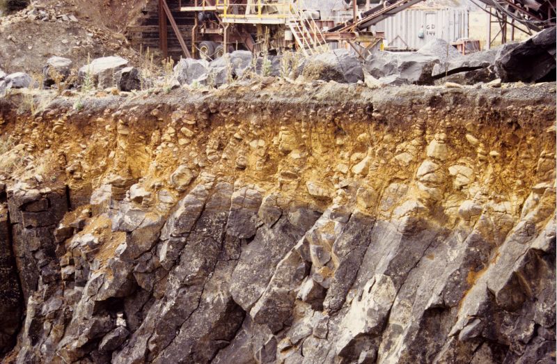
Its obviously not all basalt and granite. There's a light colored relatively unified intrusion visible in one of the gashes... looks too milky colored to me to be quartzite or even a lite granite. I have no idea what that is. Here's a page I found: https://watershed.ucdavis.edu/shed/lund/dams/Oroville/Misc.%20Oroville/Oroville.htm It says: C. Materials
Oroville Dam is located on the core of granite rock, which in turn is blanketed by metamorphic rocks. These metamorphosed volcanic and sedimentary rocks are "dense, hard, and mostly flat-lying" (DWR, Bulletin 200, Volume III, 1974). This strategic bit of planning saved the expense of having to grout the foundation extensively, since it rested on hard and flat rocks. At the time of the dam's construction, fault lines below the dam were considered inactive. I find that bit about "blanketed by metamorphic rocks" to be slightly alarming that are mostly flay lying. I wonder if that holds true for the area where the esw is located. I wonder if they set the concrete structures as far down on relatively intact stone as they could find, or if they set it on the blanket of metamorphic rocks. Whatever the case, the stone is extremely fractured, it is decomposing at the joints, it washed away at an alarming right in the places we have seen in the photos. It would be great if a geologist could get on site and examine the rocks and give us more than speculation based on eyeballing things, but that's all weve got at the moment. |
|
|
|
[#46]
Quoted:
https://pbs.twimg.com/media/C4l3rZWXUAQQuib.jpg I'm still a half dozen pages behind at this point. Inquiring haiku: All those bags of rocks Thermalito pool rises Makes it even worse? ETA: changed 'backs' of rocks to 'bags' of rocks. Spellcheck doesn't understand poetry. |
|
|
|
[#47]
Quoted:
That's not related to the current situation. That's about when it was hot... and flowing... you know lava. Not after it became rock. If a lava can easily lose it's volatiles then it'll be a more dense rock when it hardens... and flows better over ground like in Hawaii. Lavas and Magma that have a lot of dissolved volatiles in them cause volcanoes to explode like Mt St. Helens... and and can harden into light fluffy rocks such as pumice. Which type would granite be? |
|
|
|
[#48]
Quoted:
What you can piece together is a timeline on when this shit happens, I believe these are flood years, 68, 86-87, 96-97, 2016-17. Anyone see a pattern? We have dry spells followed by flooding, you would think they could figure this out Roughly every ten years. That proves that global warming/climate change is really caused by the US automobile and factories and we have to revert to caveman status to save the planet. Of course California must lead the way to verify this theory. |
|
|
|
[#49]
Quoted:
The dam will be standing if the main spillway holds. The plaque said spillway can handle 650,000CFS Oroville well be sacrificed to keep the dam. |
|
|
|
[#50]
Quoted:
Hey look, bedrock. Can we put the whole "it's not built on bedrock, it's built on fill" thing to rest now. I bet yes, bedrock. Still not settled. Wish it was settled. For several reasons. |
|
|
 Win a FREE Membership!
Sign up for the ARFCOM weekly newsletter and be entered to win a free ARFCOM membership. One new winner* is announced every week!
You will receive an email every Friday morning featuring the latest chatter from the hottest topics, breaking news surrounding legislation, as well as exclusive deals only available to ARFCOM email subscribers.

AR15.COM is the world's largest firearm community and is a gathering place for firearm enthusiasts of all types.
From hunters and military members, to competition shooters and general firearm enthusiasts, we welcome anyone who values and respects the way of the firearm.

Subscribe to our monthly Newsletter to receive firearm news, product discounts from your favorite Industry Partners, and more.
Copyright © 1996-2024 AR15.COM LLC. All Rights Reserved.
Any use of this content without express written consent is prohibited.
AR15.Com reserves the right to overwrite or replace any affiliate, commercial, or monetizable links, posted by users, with our own.


