|
[#1]
Quoted: Damn, the models just made a hard shift west They certainly did. |
|
|
|
[#2]
|
|
|
|
[#3]
Model shift, but others still hold for Florida
 https://www.weathernerds.org/tc_guidance/storm.html?tcid=AL09 |
|
|
|
[#4]
Quoted: Appears the intensity modeling has increased quite a lot. https://www.ar15.com/media/mediaFiles/381696/09L_intensity_latest_png-2537652.JPG The deeper it gets in to the warm waters in the Gulf the stronger it will get. |
|
|
|
[#5]
Quoted: Model shift, but others still hold for Florida https://www.weathernerds.org/tc_guidance/images/AL09_2022092412_GEFS_large.png?1664041131 https://www.weathernerds.org/tc_guidance/storm.html?tcid=AL09 Took a shift to the west? That’s better for me. Fingers crossed. |
|
|
|
[#6]
Quoted: Appears the intensity modeling has increased quite a lot. https://www.ar15.com/media/mediaFiles/381696/09L_intensity_latest_png-2537652.JPG Ooof. That is starting to look ugly for the Gulf coast. |
|
|
|
[#7]
2pm advisory
 |
|
|
|
[#8]
|
|
|
|
[#9]
Quoted: Ooof. That is starting to look ugly for the Gulf coast. Gas prices +15 cents Monday; I called it. |
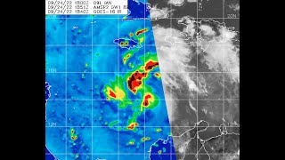
|
|
|
[#10]
Quoted: Planned it last year. No big deal. I can reschedule it. Its my ole ladies birthday trip. We will will just so a lot of boating on the East coast instead. Plans and preps. Don't have to buy a single thing and always have travel plan backups. |
|
|
|
[#11]
Quoted: Quoted: Fuckin bring it ya bitch ass storm Nah, I'm going to shoot at the storm when it hits. |
|
|
|
[#12]
Walmart pickup in Tampa normally same day, now Wednesday.
|
|
|
|
[#13]
I'm calling landfall will be Mobile.
|
|
|
|
[#14]
Quoted: I'm calling landfall will be Mobile. |
|
|
|
[#15]
Quoted: Please no, I'm on the bad side of that! Quoted: Quoted: I'm calling landfall will be Mobile. Stay safe guys. |
|
|
|
[#16]
Thing keeps moving further west at this rate Texas may need to worry, lol.
|
|
|
|
[#17]

|
|
|
|
[#18]
Beaten
|
|
|
|
[#19]
Wow! Predictions have shifted drastically in the last 12 hours.
Why are they now predicting it to lose intensity in the gulf? |
|
|
|
[#20]
Quoted: Wow! Predictions have shifted drastically in the last 12 hours. Why are they now predicting it to lose intensity in the gulf? Wind shear. |
|
|
|
[#21]
I suspected this might happen. Sorta depends on the northern jet stream. It’ll determine whether it shifts farther west or comes back east.
|
|
|
|
[#22]
Quoted: Wow! Predictions have shifted drastically in the last 12 hours. Why are they now predicting it to lose intensity in the gulf? |
|
|
|
[#23]
It looks like it shifted back east a bit, right? |
|
|
|
[#24]
For the noob hurricane guy here… wife has business trip to Orlando Tuesday aft flying out Wed afternoon via MCO? Should she cancel? Models shifting west?
|
|
|
|
[#25]
Quoted: For the noob hurricane guy here… wife has business trip to Orlando Tuesday aft flying out Wed afternoon via MCO? Should she cancel? Models shifting west? Honestly, too early to tell. |
|
|
|
[#26]
Quoted: It looks like it shifted back east a bit, right? Shifted west. Was looking at Tampa Bay earlier today, currently predicted at Big Bend area. So by Wednesday, it could be hitting anywhere from wherever BlackFox parked Skyline to Biloxi.  |
|
|
|
[#27]
Quoted: For the noob hurricane guy here wife has business trip to Orlando Tuesday aft flying out Wed afternoon via MCO? Should she cancel? Models shifting west? |
|
|
|
[#28]
Quoted: I have a cottage booked on Sanibel Island for next weekend. This better not get it cancelled. Fishing will fukin awesome just after a passing storm though. @wildboar - if all goes well I’ll be in Sanibel next weekend too. I’ll probably spend a night on the hook off the causeway before pushing into our canal by Tarpon Bay. Drop me a line…. |
|
|
|
[#29]
Quoted: For the noob hurricane guy here… wife has business trip to Orlando Tuesday aft flying out Wed afternoon via MCO? Should she cancel? Models shifting west? I think she should reconsider the trip. The whole of Florida seems to be at some chance of risk. We'll probably start seeing refugees here soon. |
|
|
|
[#30]
Fuck you Coriolis!
|
|
|
|
[#31]
Quoted: For the noob hurricane guy here wife has business trip to Orlando Tuesday aft flying out Wed afternoon via MCO? Should she cancel? Models shifting west? Tuesday would be fine... but there'd be a chance the flight out would get canceled and she'd be stuck here for a couple more days. Orlando will be fine. |
|
|
|
[#32]
Looks like a potential landfall in Cedar Key.
|
|
|
|
[#33]
Quoted: For the noob hurricane guy here… wife has business trip to Orlando Tuesday aft flying out Wed afternoon via MCO? Should she cancel? Models shifting west? She should be ok depending on wind gusts at MCO. I’d be more worried on Thursday. |
|
|
|
[#34]
|
|
|
|
[#35]
Quoted: For the noob hurricane guy here… wife has business trip to Orlando Tuesday aft flying out Wed afternoon via MCO? Should she cancel? Models shifting west? She will be fine. So will @MrHold Guaranfukkenteed. |
|
|
|
[#36]
|
|
|
|
[#37]
Recent model runs:
Significant differences in size and strength of the projected wind fields. And some comic relief via /pol: Looking forward to the next advisory. |
|
|
|
[#38]
Yes - but I prefer to watch Mike on YouTube so I don't have to look at his page And I really prefer https://www.tropicaltidbits.com/ |
|
|
|
[#39]
8 PM projection just up. Still heading west.

|
|
|
|
[#40]
Quoted: 8 PM projection just up. Still heading west. https://www.nhc.noaa.gov/storm_graphics/AT09/refresh/AL092022_5day_cone_no_line_and_wind+png/234839_5day_cone_no_line_and_wind.png I think it will be really interesting to see the morning predictions and models based on the data from the flights today. I don't wish it on anyone, but I would be lying if I didn't have done hope seeing it slip west (the gf has been saying it was going that way for sure). |
|
|
|
[#41]
Quoted: @wildboar - if all goes well I’ll be in Sanibel next weekend too. I’ll probably spend a night on the hook off the causeway before pushing into our canal by Tarpon Bay. Drop me a line…. Right on man. Not sure if I am trailering my boat over but if I make it I will damn sure let you know. |
|
|
|
[#42]

|
|
|
|
[#43]
FORECAST POSITIONS AND MAX WINDS INIT 25/0300Z 14.7N 77.7W 45 KT 50 MPH 12H 25/1200Z 15.3N 79.3W 55 KT 65 MPH 24H 26/0000Z 16.6N 81.0W 70 KT 80 MPH 36H 26/1200Z 18.3N 82.5W 85 KT 100 MPH 48H 27/0000Z 20.1N 83.7W 100 KT 115 MPH 60H 27/1200Z 22.0N 84.5W 115 KT 130 MPH...OVER WEST TIP OF CUBA 72H 28/0000Z 23.9N 84.9W 120 KT 140 MPH...OVER WATER 96H 29/0000Z 27.2N 84.8W 115 KT 130 MPH 120H 30/0000Z 29.6N 84.1W 80 KT 90 MPH |
|
|
|
[#44]
Yes, Mikes Weather site, good place for all the info Heading more west according to tracks 
|
|
|
|
[#45]
I like this channel for hurricane season.
 [Saturday Evening] TD9 gets named Ian; Significant Hurricane Expected to impact Caribbean and U.S. |
|
|
|
[#46]
Levi knows his stuff. |
|
|
|
[#47]
This thing can stop its slide west any time now.
|
|
|
|
[#48]
Latest recon shows the system is still not stacked and a loose circulation SW of where the model suites have been initiating from.
This should mean another westward shift in the 6am track after the data has been added. The hurricane center had expected it to be forming an eye by now. |
|
|
|
[#49]
5:00 AM

|
|
|
|
[#50]
Looks like it hasn't really shifted West any more, but makes landfall a few hours later. Looks like I'll be riding it out in the Gulf. Windy.com is only forecasting 50 kt gusts where we are.
|
|
|
 Win a FREE Membership!
Sign up for the ARFCOM weekly newsletter and be entered to win a free ARFCOM membership. One new winner* is announced every week!
You will receive an email every Friday morning featuring the latest chatter from the hottest topics, breaking news surrounding legislation, as well as exclusive deals only available to ARFCOM email subscribers.

AR15.COM is the world's largest firearm community and is a gathering place for firearm enthusiasts of all types.
From hunters and military members, to competition shooters and general firearm enthusiasts, we welcome anyone who values and respects the way of the firearm.

Subscribe to our monthly Newsletter to receive firearm news, product discounts from your favorite Industry Partners, and more.
Copyright © 1996-2024 AR15.COM LLC. All Rights Reserved.
Any use of this content without express written consent is prohibited.
AR15.Com reserves the right to overwrite or replace any affiliate, commercial, or monetizable links, posted by users, with our own.


