|
[#1]
Quoted:
I grew up along the ohio river in southern IN & KY. The river has changed course over the years...several miles in some places. The land which was originally IN on the north side of the river, and KY on the south side of the river, has a date. Since that date the course or the river has moved. The state boundaries on those original dates have not changed, but now they are on the other side of the river. Near Evansville, IN the course of the Ohio has shifted south leaving that original boundary. Now there are several thousand acres of KY which find themselves on the north side of the river. This accretion has slowed considerably since the flood control dams were built, but it is still happening. A fairly amazing example of how these rivers change course can be seen on Google Earth along the Mississippi where it's course has shifted generally east many miles. The old river course(s) can me clearly seen in many areas long the Arkansas/Tennessee border. The area between West Memphis and Forrest City, AR has multiple old courses which are pretty apparent. I now return you to your regularly scheduled thread.  Quoted:
So if you have a non-waterfront parcel and it gets covered by lava, you still own the entire parcel. The boundaries as defined by GPS coordinates are unchanged. If you own waterfront property - even if your deed reads "the the mean high water line" or similar - you still own X acres and if lava extends the land so that the waterline is now hundreds of yards farther away... You do not gain acreage. And you lose your waterfront. On one hand I think that's fucked up - I own to the high water mark, so I still own to the high water mark. If all that filled in was 20' of sand, nobody would dispute the claim. Now that it's 500' of lava, all of a sudden I no longer own to the water? That's not cool. I can see both sides of the argument. Buying property in an area where there have been multiple lava flows every century for thousands of years is a risky proposition. The land which was originally IN on the north side of the river, and KY on the south side of the river, has a date. Since that date the course or the river has moved. The state boundaries on those original dates have not changed, but now they are on the other side of the river. Near Evansville, IN the course of the Ohio has shifted south leaving that original boundary. Now there are several thousand acres of KY which find themselves on the north side of the river. This accretion has slowed considerably since the flood control dams were built, but it is still happening. A fairly amazing example of how these rivers change course can be seen on Google Earth along the Mississippi where it's course has shifted generally east many miles. The old river course(s) can me clearly seen in many areas long the Arkansas/Tennessee border. The area between West Memphis and Forrest City, AR has multiple old courses which are pretty apparent. I now return you to your regularly scheduled thread. Interestingly the supreme court actually talked about this in their opinion No court sitting at common law has had occasion to deal with the question of lava extensions. We understand this case to be one of first impression and are mindful of its potential impact. The decision is one which will count for the future. In surveying the common law, the only doctrines which are even of conceivable application are those of accretion and avulsion. We agree with the appellees' statement in the proceedings below that "the common law on accretion and avulsion in other states is not directly on point." However, the appellees contend that the "logic of cases based on these concepts would lead to the rule that volcanic additions on the Island of Hawaii go to the abutting owner." We disagree.
As known at common law, "the term `accretion' denotes the process by which the area of owned land is increased by the gradual deposit of soil due to the action of a bounding river, stream, lake, pond, or tidal waters." 7 R. Powell, Real Property (1976) s 983. When accretion is found, the owner of the contiguous land takes title to the accreted land. Halstead v. Gay, 7 Haw. 587, 588 (1889). Professor Powell indicates that the "basic justification for a doctrine which permits a boundary to follow the changing stream bank is the desirability of keeping land riparian which was riparian under earlier facts, thus assuring the upland owners access to the water and the advantages of this contiguity." Id. While the accretion doctrine is founded on the public policy that littoral access should be preserved where possible, the law in other jurisdictions makes it clear that the preservation of littoral access is not sacrosanct and must sometimes defer to other interests and considerations. For example, it is well established in California "that accretions formed gradually and imperceptibly, but caused entirely by artificial means ... belong to the state or its grantee, and do not belong to the upland owner." Carpenter v. City of Santa Monica, 63 Cal. App. 2d 772, 794, 147 P.2d 964, 975 (1944); People v. Hecker, 179 Cal. App. 2d 823, 4 Cal. Rptr. 334 (1960). In California it is also well settled that being cut off from contact with the sea is not basis for proper complaint. In Los Angeles Athletic Club v. Santa Monica, 63 Cal. App. 2d 795, 799, 147 P.2d 976, 978 (1944), a companion case to Carpenter, supra, the court noted (citations omitted): It is well settled that the littoral rights of an upland owner who owns no title to tidelands adjoining his property are subject to termination by whatever disposition of tidelands the state, or its grantees, in the exercise of their trust, choose to make." Likewise, in cases where there have been rapid, easily perceived and sometimes violent shifts of land (avulsion) incident to floods, storms or channel breakthroughs, preexisting legal boundaries are retained notwithstanding the fact that former riparian owners may have lost their access to the water. |
|
|
|
[#2]
|
|
|
|
[#3]
@Dace
I've been in the lands and minerals side of the oil biz for over 40 years and have had to deal with these issues occasionally running title for oil & gas wells. Once the state 'patents' a parcel of land to someone, usually done by the section ( 640 acres), the only way the title changes hands is by sale, heirship, or eminent domain proceedings Originally, the state owns all the lands within it's borders. Over time they generally sell it off. In Texas, they retained sections of land as 'State School Lands'. Originally they set aside over 42 million acres which is checkerboarded across the state and each county. Relinquishment Act |
|
|
|
[#4]
has some low flight video over Kapoho.
 Hawaii Volcano Eruption Update - Thursday Afternoon (June 7, 2018) |
|
|
|
[#5]
|
|
|
|
[#6]
|
|
|
|
[#7]
That was cool!!!!
|
|
|
|
[#8]
 Hawaii''s Kilaeuea Volcanic Eruption: A Stunning Time-Lapse |
|
|
|
[#9]
|
|
|
|
[#10]
Quoted:
... that's beautiful Quoted:
... that's beautiful |
|
|
|
[#11]
Kapoho Bay is already labeled Kapoho Point on google maps.
|
|
|
|
[#12]
Quoted:
Kapoho Bay is already labeled Kapoho Point on google maps. https://volcanoes.usgs.gov/observatories/hvo/multimedia_uploads/multimediaFile-2205.jpg |
|
|
|
[#13]
Quoted:
Kapoho Bay is already labeled Kapoho Point on google maps. https://volcanoes.usgs.gov/observatories/hvo/multimedia_uploads/multimediaFile-2205.jpg |
|
|
|
[#14]
Quoted:
So, is Kapoho point a lava shelf, or is it solid on the seabed? Is it going to break off? |
|
|
|
[#15]
dawn overflight.
https://vimeo.com/274206536 I usually screen cap it to use as reference to determine where the lava is but there wasn't much different or any real good shots of the edges near houses to let me do that. |
|
|
|
[#16]
Quoted:
The bay it covered was very shallow... so it's not overhanging... I don't think it's going to be going anywhere for a long time. |
|
|
|
[#17]
Quoted:
How cool would it be if we could drill for felsic lava like asphalt? We need more land! No problem *Splorge* There you are. A brand new obsidian and basalt island. That'll be 87 million dollars. 
But how do you control it? Turn it off? Once you pop that cork, you are committed to whatever natural forces exist under your feet - it may do nothing, or it could bury everything for 500 miles in every direction under 2 miles of lava. |
|
|
|
[#18]
Quoted:
But how do you control it? Turn it off? Once you pop that cork, you are committed to whatever natural forces exist under your feet - it may do nothing, or it could bury everything for 500 miles in every direction under 2 miles of lava. The old saying, " the only thing they aren't making more of is land." Yeah, but sometimes, more land gets made spontaneously. We should figure out a way to tame that process.
|
|
|
|
[#19]
1. Concrete pumpers
2. Invent a bunch of stuff with science to have lava pumpers. 3. ??? 4. Profit |
|
|
|
[#20]
Quoted:
1. Concrete pumpers 2. Invent a bunch of stuff with science to have lava pumpers. 3. ??? 4. Profit |
|
|
|
[#21]
Quoted:
That's gonna take a LOT of gnomes...  A Business Plan |
|
|
|
[#22]
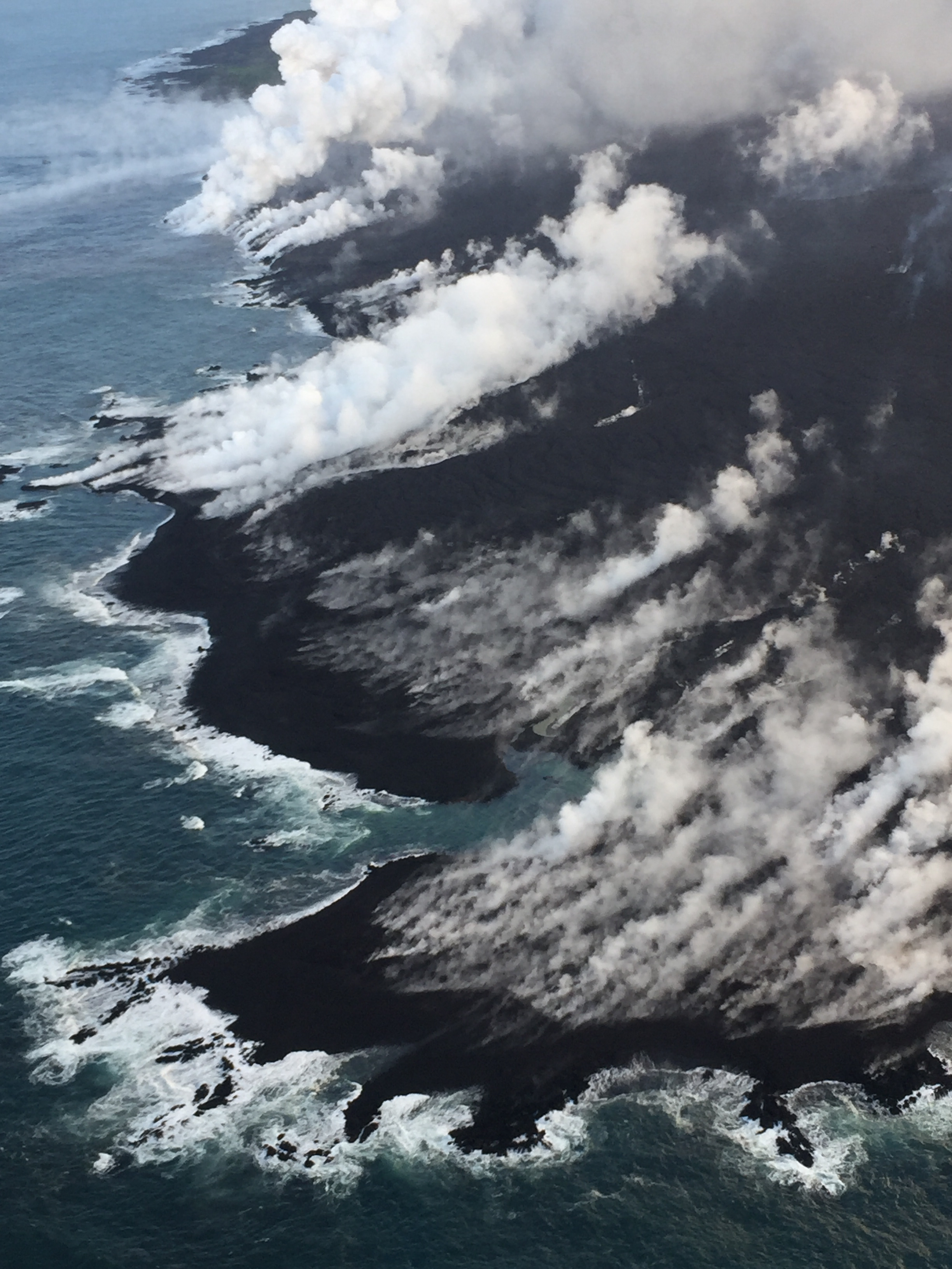
Steam fissures advancing to the left by quiet a bit.

|
|
|
|
[#23]
Quoted:
But how do you control it? Turn it off? Once you pop that cork, you are committed to whatever natural forces exist under your feet - it may do nothing, or it could bury everything for 500 miles in every direction under 2 miles of lava. Quoted:
Quoted:
How cool would it be if we could drill for felsic lava like asphalt? We need more land! No problem *Splorge* There you are. A brand new obsidian and basalt island. That'll be 87 million dollars.
But how do you control it? Turn it off? Once you pop that cork, you are committed to whatever natural forces exist under your feet - it may do nothing, or it could bury everything for 500 miles in every direction under 2 miles of lava. |
|
|
|
[#24]
Quoted:
Pfft, just turn the valve. You did put in a valve didn't you? Quoted:
Quoted:
Quoted:
How cool would it be if we could drill for felsic lava like asphalt? We need more land! No problem *Splorge* There you are. A brand new obsidian and basalt island. That'll be 87 million dollars.
But how do you control it? Turn it off? Once you pop that cork, you are committed to whatever natural forces exist under your feet - it may do nothing, or it could bury everything for 500 miles in every direction under 2 miles of lava. |
|
|
|
[#25]
There is a really good interactive before and after pic here of Kapoho Bay.
Scroll down to get to the pic with the slider bar. http://www.businessinsider.com/hawaii-kilauea-volcano-before-after-satellite-pictures-2018-6 |
|
|
|
[#26]
|
|
|
|
[#27]
Is that view from the VisCen?
|
|
|
|
[#28]
A lot of interesting stuff and some amazing video in here https://www.zerohedge.com/news/2018-06-09/stunning-hawaii-aerial-footage-shows-mile-wide-volcanic-front-230-ft-lava-geyser
|
|
|
|
[#29]
Quoted:
Is that view from the VisCen? https://youtu.be/JlP-8JiKOS8  Live Stream - Kilauea Volcano It's precise location I don't know... but I don't think it's from the visitor center. |
|
|
|
[#30]
this thread probably has most of the people on arfcom who are interested in volcanoes... so I guess here would be the best place to ask...
I've been looking for a particular volcano demonstration. It showed how the more gas rich ring of fire type volcanoes work. It used a large round bodied Flask with honey in it. The honey was pressurized to encourage gas to dissolve into it. Then I think it was heated just a little to force the stopper off the top... upon doing so the honey almost instantaneously erupted from the flask leaving only a thin film behind within. I can't remember where I saw it and all the terms I've been using to search are coming up short. |
|
|
|
[#31]
Quoted:
this thread probably has most of the people on arfcom who are interested in volcanoes... so I guess here would be the best place to ask... I've been looking for a particular volcano demonstration. It showed how the more gas rich ring of fire type volcanoes work. It used a large round bodied Flask with honey in it. The honey was pressurized to encourage gas to dissolve into it. Then I think it was heated just a little to force the stopper off the top... upon doing so the honey almost instantaneously erupted from the flask leaving only a thin film behind within. I can't remember where I saw it and all the terms I've been using to search are coming up short. Round bottom boiling flasks, with or without ground glass joint necks, and including multiple necks Florence flasks, which have a flat bottom. Volumetric flasks, which have a precise capacity at STP And pressure/vacuum round bottom flasks which are exactly like the first type except thicker walls. |
|
|
|
[#32]
 Magma Viscosity, Gas Content & Milkshakes |
|
|
|
[#33]
Can't find the particular one you're looking for either.
|
|
|
|
[#34]
I've blown a thermometer cork on a number of closed systems, though. It's easy to replicate. Explosive decompression is real easy. Everyone has seen it. Shake up a can of coke. Same same.
|
|
|
|
[#35]
Boiling a closed system under reflux and the condenser coolant flow falls behind, pop!, the thermometer cork blows out of the side neck, and reagents splattered everywhere. Fun times.
|
|
|
|
[#36]
I had a 2000ml round bottom boiling flask with a 24/40 neck blow up in my hand once. I have to this day no clue why, but no one ever found even a sliver of glass in the lab. It apparently vaporized to such a finely divided state, it was just gone. I stood there in a lab coat and milky goggles holding a 2" long ground glass neck, and that was all. i'm sure I had that look.
|
|
|
|
[#37]
I think it was a Florence flask. I didn't include that name in my post as I didn't think anyone would know what that was.
I'm thinking this was an old demonstration from like a Nat Geo or Discovery Channel show way back in the day. I've been searching for honey magma chamber demonstration or simulation or pressurized honey or honey eruption and coming up empty. I just remember the demo and the high speed video of it really making an impression on me about the power contained and then unleashed in such eruptions. |
|
|
|
[#38]
So, is it done?
|
|
|
|
[#39]
The episode in question was on a Discovery Channel program which covered the topic of supervolcanoes, and IIRC it was in the 2004-2005 time frame. The two ingredients used were pine tar and turpentine. The former is a highly viscous analog of magma, while the latter approximated the solvent effect that superheated H2O-CO2 has on 'mush' (partially crystallized magma).
See "gas sparging" for more details on the reheat principle and how it makes the magma reservoir volatile. What the experiment proved is that there's a hysteresis effect involved when degassing starts. That is, it doesn't stop until ALL the volatiles come out of solution, and in the process the heavier contents of the chamber are blown completely into fine particulates as they're erupted. Ergo, you get a lot of tuff and ash. |
|
|
|
[#40]
Quoted:
So, is it done? "This is a Civil Defense Message for Sunday, June 10 at 6:00 in the morning. Hawaiian Volcano Observatory reports that the eruption continues in the lower East Rift Zone. Fissure 8 continues to produce a large channelized flow that is entering the ocean at Kapoho Bay and producing a large laze plume. Hawaiian Volcano Observatory also reports that a steam explosion occurred at the Kilauea Summit early this morning, so be aware of ash fallout if your commute takes you through Ka’u. Due to the lava entering the ocean, the following policies are in effect: Avoid the laze plume. Be aware that the laze plume travels with the wind and can change direction without warning. Due to the current volcanic activity, the following policies are in effect: Leilani Estates West of Pomaikai Street is open only to residents with official credentials; there is no curfew. Government Beach Road, between Kahakai Boulevard and Cinder Road is open to Waa Waa and Papaya Farms Road only to residents with official credentials; there is no curfew. Residents in these areas should heed warnings from Civil Defense officials and be prepared to evacuate with little notice. The shelter at Pahoa Community Center is open and pet-friendly. The Keaau Armory shelter has reached capacity. Hawaiian Volcano Observatory reports volcanic gas emissions remain very high from fissure eruptions. Due to the elevated gas levels, the following is provided for your information: If you feel the effects of gas exposure shelter-in-place or leave the immediate area. You can monitor sulfur dioxide and hydrogen sulfide on Hawaii Island by visiting the Civil Defense website." |
|
|
|
[#41]
Quoted:
So, is it done? It's got a path to the ocean so it's not consuming more houses at this time. But Lava is actively being erupted... the lava river keeps flowing... and anywhere along the entire length of that 7+mile long channelized flow could have that channel wall collapse at any moment. Which would send fast moving flows to consume more. It isn't done until it's done... and even then it's just the lull until the next eruption. |
|
|
|
[#42]
|
|
|
|
[#43]
today.

|
|
|
|
[#44]
|
|
|
|
[#45]
I've just become aware of the Hawaii Civil Defense Flickr account. Lots of photos.
https://www.flickr.com/photos/141970887@N04/sets/72157694698599162/with/27856555777/ |
|
|
|
[#46]
Quoted:
I've just become aware of the Hawaii Civil Defense Flickr account. Lots of photos. https://www.flickr.com/photos/141970887@N04/sets/72157694698599162/with/27856555777/ |
|
|
|
[#47]
This has the pine tar demonstration you were looking for.
 Failed To Load Title @Master_of_Orion Starts ~25:00 That flask looks like it was probably blown just for that. I've never seen one like that in catalogs or a lab. they used Acetone for the gasses, as the simplest ketone, it's quite volatile. |
|
|
|
[#48]
It’s a little concerning with all the volcanic activity that’s occurring around the world, especially with Yellowstone and Steamboat Geyser which is the largest geyser in the world and typically dormant.... well until this year with 8 eruptions and still counting. It’s baffling scientist on why so much activity as of late.
I had the strangest nightmare back in February, way before all the volcanic news. In my dream I was running with my wife and daughters as fire engulfed us, and I had the realization that this was the end. Those pictures of the Guatemalan families passing away as they ran from the pyroclastic flow really hit me in the gut, since that was essentially my nightmare but with ash instead of fire. Odd similarity and or bad timing Steamboat geyser. |
|
|
|
[#49]
Quoted:
It’s a little concerning with all the volcanic activity that’s occurring around the world, especially with Yellowstone and Steamboat Geyser which is the largest geyser in the world and typically dormant.... well until this year with 8 eruptions and still counting. It’s baffling scientist on why so much activity as of late. I had the strangest nightmare back in February, way before all the volcanic news. In my dream I was running with my wife and daughters as fire engulfed us, and I had the realization that this was the end. Those pictures of the Guatemalan families passing away as they ran from the pyroclastic flow really hit me in the gut, since that was essentially my nightmare but with ash instead of fire. Odd similarity and or bad timing Steamboat geyser. http://volcano.si.edu/faq/index.cfm?question=eruptionsbyyear |
|
|
|
[#50]
Quoted: There is no data that suggests this year is any different or worse then another. http://volcano.si.edu/faq/index.cfm?question=eruptionsbyyear I will never see Yellowstone blow or see a major asteroid hit the earth. I’m not a doomsday person. More of an inquiry and ponder type. |
|
|
 Win a FREE Membership!
Sign up for the ARFCOM weekly newsletter and be entered to win a free ARFCOM membership. One new winner* is announced every week!
You will receive an email every Friday morning featuring the latest chatter from the hottest topics, breaking news surrounding legislation, as well as exclusive deals only available to ARFCOM email subscribers.

AR15.COM is the world's largest firearm community and is a gathering place for firearm enthusiasts of all types.
From hunters and military members, to competition shooters and general firearm enthusiasts, we welcome anyone who values and respects the way of the firearm.

Subscribe to our monthly Newsletter to receive firearm news, product discounts from your favorite Industry Partners, and more.
Copyright © 1996-2024 AR15.COM LLC. All Rights Reserved.
Any use of this content without express written consent is prohibited.
AR15.Com reserves the right to overwrite or replace any affiliate, commercial, or monetizable links, posted by users, with our own.


