|
[#1]
|
|
|
|
[#2]
I'll check in again. I'm in Wilmington but on the northern side and out of the surge area. About 6 miles from RTUtah's place in Wrightsville. I've lived here through many hurricanes in the past including cat 3's I'm slightly relieved that they are predicting a drop before it hits land, but it's all a roll of the dice at this point.
Many (most) of the people I know that live inland are staying. Everyone I know that lives on the beaches are leaving. I'm prepared other than some tidying up on my property I'll do tomorrow. I went to Lowe's today to pick up some convenience preparations. Saw many generators in people cart's and not a single gas can. Every time I click on this thread it's 4 pages more. Edit: I'm 45 ft above sea level. |
|
|
|
[#3]
Quoted:
Find out when deliveries are scheduled and be first in line. You planning to bug out? Quoted:
Quoted:
Fuck sake, I'm in University, Charlotte, wife went to pick up drugs from CVS and went to top off gas in the car - gas station was all out of gas. |
|
|
|
[#4]
They pulled the Major symbol off the mainland in the latest track.
Landfall wind speed estimate is down also. Big, big difference between 140 mph and 115 mph. Bad point is from just offshore to landfall calling for a 24 hour spread. |
|
|
|
[#5]
Quoted:
11pm guidance is out. https://www.AR15.Com/media/mediaFiles/433230/HURRICANE_FLORENCE__4_-668885.JPG The flooding here is going to suck. The flooding in Lumberton will be Biblical. Fuck. |
|
|
|
[#6]
Quoted:
Major models have mostly shifted to the south. Not looking good at all for our place at Garden City. I live between Columbia and Charlotte, and everything is still pretty normal here. People just going about life as usual. I stocked up on some non perishable foods after work today and will top off all my gas tanks tomorrow. I live on high ground, and it's been very dry here, so I'm not concerned about any flooding. Prepared to lose power for a few days, but I'm not terribly concerned about that. I think that with the major models shifting south this evening, people around here will wake up tomorrow, see updated cone maps, and start freaking out. |
|
|
|
[#7]
Quoted:
They pulled the Major symbol off the mainland in the latest track. Landfall wind speed estimate is down also. Big, big difference between 140 mph and 115 mph. Bad point is from just offshore to landfall calling for a 24 hour spread. Damn. |
|
|
|
[#8]

|
|
|
|
[#9]
Quoted:
I know many folks won't give a shit but for Pete's sake if you have to evac, take your pets with you. I just read where people are cutting their dogs and cats loose before they bug out, because they're staying at a hotel and don't want to pay extra for them. |
|
|
|
[#10]
Quoted: Look at all the people who are bugging in at potential landfall locations. Why? They don't believe it could happen to them- probably because they have never seen it happen before. Normalcy bias and stubbornness combined- they do not understand the danger or possibility of death and destruction. It takes a man to face the unknown, act decisively and embrace the financial/personal risk of getting the fuck out. It's a hard decision to make- and it's difficult to actually do. It's easy to stay put in your comfort zone and hope for the best...conversely- you can't fault the men who choose to get themselves, their infants, wives and elderly as far away from potential death and destruction as possible. This isn't about people being spoiled or cowardly- this is about survival. You don't take risks that you don't have to- the farther you can reasonably get from the chaos, the better off you will be. "Better safe than Sorry" is more than a mantra, it's a survival strategy. There is a lot more to calculate in all of this than power outages and scary noises. |
|
|
|
[#11]
Quoted:
There are some of you that truly get a hard on for these storms.  |
|
|
|
[#12]
Quoted:
we are in for a bit of wind and rain here - fully expecting to lose power for a while though. 
|
|
|
|
[#13]
Quoted:
https://pbs.twimg.com/media/Dm3NBSGUcAEthLh.jpg https://pbs.twimg.com/media/Dm3NBSEU0AAU8Rk.jpg?format=jpg&name=orig |
|
|
|
[#14]
Quoted:
Who all is ready for two months of CONSTANT media coverage of the hurricane aftermath, blaming Trump for the old gods of Sumeria punishing us or the Russian weather control machine or something, because Trump. LOL.....I bet they will show a lot of the American Red Cross though.....A week and a half after the storm is over when they get there. 
|
|
|
|
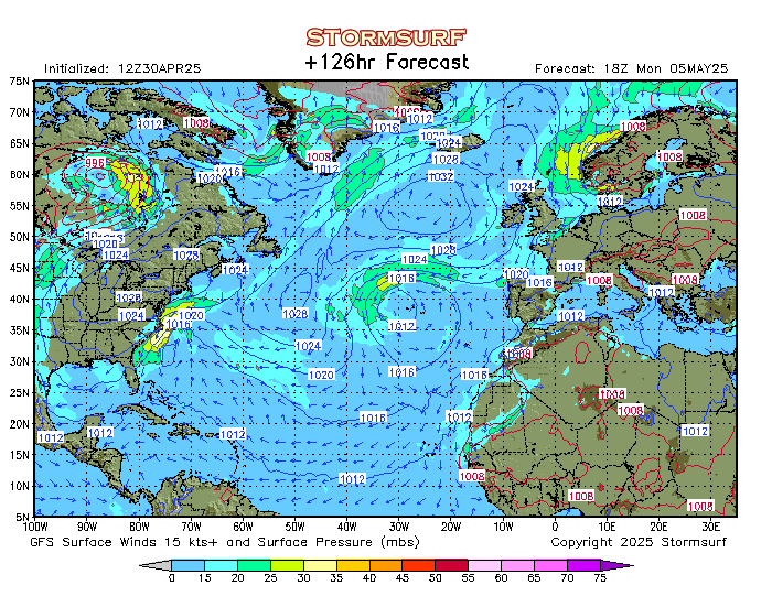
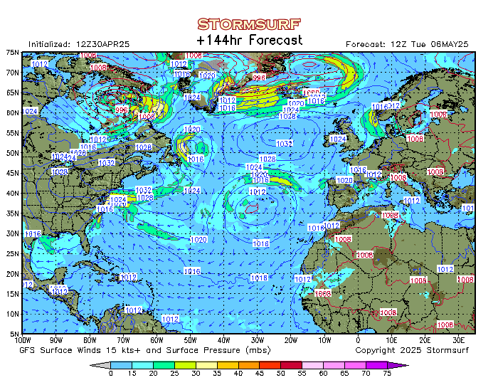
[#15]
This animation has been the most accurate of any prediction so far. It was showing it turning south before any others were. That was 9:30am this morning, the other models didn't show it turning until the afternoon.
http://www.stormsurfing.com/cgi/display_alt.cgi?a=natla_slp 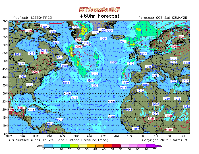
|
|
|
|
[#16]
|
|
|
|
[#17]
Quoted:
https://pbs.twimg.com/media/Dm3NBSGUcAEthLh.jpg https://pbs.twimg.com/media/Dm3NBSEU0AAU8Rk.jpg?format=jpg&name=orig |
|
|
|
[#18]
Quoted:
If you are expecting to go through life with no bad weather, all sunny skies, no scary storms, never a power outage, then, no you won't be OK. You need to invest in an RV and resolve to drive perpetually to avoid storms. Because they have always happened and they aren't going away. Now with the population density on the coast people living right on the coast (there is a reason the coast wasn't developed until relatively recently) the entire eastern seaboard must evacuate a week before every hurricane. Or you can realize that you live where those people are going to escape the storm. There will probably be flooding. There will probably be electrical outages. Buy there won't be mass casualties. When I was a kid we regularly went without power. First living in the pa mountains during ice storms and floods, then in Florida when we moved there. The electricity goes out frequently where I live. I manage. I do more than manage, I have my own little party with my preps. For cripes sake, some of you people need to get a grip. People have been living in the aftermath of hurricanes for centuries. A lot of y'all don't even live on the coast and you're peeing your pants. You aren't going to die because the electricity goes out for awhile. If you live in a low lying area you don't have to bug out to Arizona, stay with a friend that doesn't live in a low lying area. Y'all wouldn't have lasted a year in rural PA in the 50's. We had floods EVERY YEAR! We also had ice storms every year!! We knew this and prepared the best we could. So wipe your face off with a hankie and act like a man. Except those that live on the coast. You need to go somewhere else. Or not. You roll the dice, you take your chances. I can't wait to see GD when tshtf. It will almost be as many tears as when Trump won. 
|
|
|
|
[#19]
Quoted: Maybe a bit at first but since it's going to hit red states the worse the MSM will soon move on in a hurry. They don't like reporting on those that tend to fend for themselves and help each other. Were it not for Fox and the Weather Channel you would never had seen anything about the Cajun Navy. LOL.....I bet they will show a lot of the American Red Cross though.....A week and a half after the storm is over when they get there. |
|
|
|
[#20]
local news just showed the hurricane is going to sit on the Carolina's for 24+ hours
|
|
|
|
[#21]
Getting on the road with two kids and two cats. Heading south to Ga. We live two blocks from the beach at Carolina/Kure Beach. I went to our street corner and took pics in all directions. I expect it to look a lot different when I see it again. Pics from this morning’s serene sunrise:


Hard to believe what is approaching. |
|
|
|
[#22]
Quoted:
People on the coast need to evacuate. People 100 miles inland need to quit panicking like they are going to die. Especially when they live in an area that the coastal people are going to. Quoted:
People on the coast need to evacuate. People 100 miles inland need to quit panicking like they are going to die. Especially when they live in an area that the coastal people are going to. Keep in mind- this isn't about "panicking." There is a whole world full of people out there who depend on modern civilization and all that it offers. What if you have a 2 year old who depends on nebulizer treatments to keep their airway flowing? What if someone sustains a life threatening injury (for whatever reason) and no ER or ambulance is available? There is no possible way to prepare for every contingency or unknown- which means, it's better if you avoid having to. You're right about the coast- I'll give you that. But not everyone goes by the same cookie cutter parameters for day-to-day needs. There are tons of people who need to get the fuck away from areas that will be without power, EMS or medical services. That's not factoring in looting and the natural tendency of bad people to prey on the weak. That's not counting the possibility of a freak weather scenario that causes more damage from the storm than is anticipated. If you can ensure your family's safety, comfort and access to modern medical treatment- why shouldn't you? There is NO way you can fault anyone for wanting to move their family as far away from that mess as is possible. Who knows what the fuck this thing is going to do? Nobody knows exactly where it's going- exactly how bad it will be. It has a mind of it's own and will do whatever it wants. Better safe than sorry...a mini-vacation is preferable to any other option for people who are in the zone of uncertainty. I'm still hoping the thing gutterballs off in to the deep blue or gets it's balls cut off. I'd love to be wrong- really, I would. You guys hitting the road, be safe. See my advice from earlier in this thread: Quoted:
You guys who are leaving the danger zone...drive carefully. Drive defensively- pay constant attention to the road and your surroundings. Watch your lane changes and keep a safe stopping distance behind other vehicles. DON'T get distracted with your phone or text while driving- don't get so wrapped up in your thoughts or conversation that you lose focus. Give developing road conditions immediate, top priority and focus. Drive "for" the other drivers on the road- that is to say, drive in a way that plans for/anticipates their carelessness. People get panicky, batshit crazy and aggressive behind the wheel during these times. Watch out for druggie or drunkie drivers. Task your passengers with the responsibility of (1) Helping you to stay awake/alert, (2) Constantly helping you watch the road and other drivers, (3) Gathering information via Waze/Social Media/News/etc about the condition of traffic/roads ahead of you on the route. (4) Keeping the kids quiet, consoling them, etc. Wear your seatbelts and make sure car-seats for the bebbies are strapped down tight. |
|
|
|
[#23]
Quoted:
During Mathew we had cell service the whole time. Verizon waved the data limits. I have 4 large power cells, we had phone service, communication, and entertainment the entire time. A solar charger isn't going to do much good if you only have one power cell, mine take over 8 hours to fully charge. The last time I charged one at the hospital and spouse came by and swapped out hers. After that I got more power cells. I only live a mile from the hospital I work so at least I can charge my power cells. I didn't have AC until I was over 30 so I can do without that for awhile. I can can any meat in the freezer. I fully expect a power outage and some flooding just from the rain. We have that anyway though. My flood insurance is up to date so that's one less worry. Mathew took are of a lot of the trees and we had more taken down or trimmed. The trees are the biggest risk around here. This bitch is headed directly at the coast at a ~90* angle...and the NE quadrant is gonna make landfall. Be safe! |
|
|
|
[#24]
Quoted:
local news just showed the hurricane is going to sit on the Carolina's for 24+ hours |
|
|
|
[#25]
How safe is it about 12 miles inland from the coast at 35ft elevation?
|
|
|
|
[#26]
Quoted:
How safe is it about 12 miles inland from the coast at 35ft elevation? |
|
|
|
[#27]
Quoted:
Not bad at all for Alabama. (for this storm) |
|
|
|
[#28]
|
|
|
|
[#29]
Quoted:
11pm guidance is out. https://www.AR15.Com/media/mediaFiles/433230/HURRICANE_FLORENCE__4_-668885.JPG |
|
|
|
[#30]
Quoted:
https://www.AR15.Com/media/mediaFiles/651/57350683-D716-43D3-A4EF-0D2D933C65B8-668937.JPG Just a little humor, stay safe people! 
Soundtrack for the Official ARFCOM hurricane roadtrip?  The White Buffalo - Highwayman [Single] (AUDIO) |
|
|
|
[#31]
Quoted:
How safe is it about 12 miles inland from the coast at 35ft elevation? Oh, don't forget to add the ~10 mph increase in wind speed for your 35 ft elevation. Seriously, if you're that close to the coast between Charleston, SC & Virginia Beach, VA....you need to seriously consider taking a vacation. |
|
|
|
[#32]
Quoted:
Oh, don't forget to add the ~10 mph increase in wind speed for your 35 ft elevation. |
|
|
|
[#33]
Quoted:
Are people going to get into the same argument that they got into with Irma, where a terrible storm chaser was standing outside in the middle of the parking lot and said "That was just 150 mph winds!!!!" as the eye wall passed over him and people believed he was talking about 150 mph winds at ground level? People were saying everything was going to be leveled because of those winds but really only the tops off some trees were taken out. I tried to explain the elevation and wind speeds but it was lost on most people. Here's information about the formula. |
|
|
|
[#34]
Quoted: Oh Joy...Black line on Greenville. Eta- looks like it will be a depression when it hits here. |
|
|
|
[#35]
Quoted:
Hate to be "that guy" but is there a video of that on youtube? |
|
|
|
[#36]
Quoted:
Hate to be "that guy" but is there a video of that on youtube? Maybe. It's the part of the fuel rail that looks like where you put air in a bicycle tire. The tool to pull the core is available pretty much anywhere bicycle inner tubes are sold. |
|
|
|
[#37]
Quoted: Wonder how bad it will get here in the Greenville area? Eta- looks like it will be a depression when it hits here. |
|
|
|
[#38]
Quoted:
Well...assuming you're near the path of the storm and if you figure the storm is moving 17 mph...you're 42 minutes safer than you would be on the coast. Oh, don't forget to add the ~10 mph increase in wind speed for your 35 ft elevation. Seriously, if you're that close to the coast between Charleston, SC & Virginia Beach, VA....you need to seriously consider taking a vacation. Quoted:
Quoted:
How safe is it about 12 miles inland from the coast at 35ft elevation? Oh, don't forget to add the ~10 mph increase in wind speed for your 35 ft elevation. Seriously, if you're that close to the coast between Charleston, SC & Virginia Beach, VA....you need to seriously consider taking a vacation. |
|
|
|
[#39]
Quoted:
I knew he would show up. |
|
|
|
[#40]
Quoted: I’m sure he’s an easy punching bag for some. But, transcribe his video into text, and it basically reads like half the posts in this thread. Frankly, it might be more conservative than a considerable number of said posts. |
|
|
|
[#41]
Pretty impressive looking on GOES-16 but not quite as organized as I thought it would be.
https://weather.cod.edu/satrad/exper/?parms=continental-conus-14-48-1-100-1&checked=map&colorbar=undefined https://weather.cod.edu/satrad/exper/?parms=meso-meso1-14-200-1-100-1&checked=map&colorbar=undefined |
|
|
|
[#42]
Here are some good tips for surviving without power for a few days.
https://www.facebook.com/goldhillvfd/posts/470618900086450 |
|
|
|
[#43]
Double Tap
Delete |
|
|
|
[#44]
This will be a major flood event in NC and SC.

|
|
|
|
[#45]
Quoted:
Thanks for the serious answer. I don't live near the coast and have never been through a hurricane, so I genuinely wanted to better understand it. Sounds like staying that close is pretty risky. After Katrina, (which came ashore as a Cat 3), the damage extended roughly 60 miles inland and thousands of pine trees were snapped off ~20' above ground all the way inland to Hattiesburg, MS. Closer to the coast, power poles were snapped off. There was no power for a couple of weeks. The roads were blocked by debris making travel nearly impossible without getting out with a chainsaw and cutting the trees out of the road. When we got to Bay St. Louis, the surge had come in about 30' deep in the bay. There used to be a railroad bridge over the bay to Henderson point...the rails were extending about 200' from the shore and were twisted up like pretzels. It was a happy place. 
This storm is forecast to be worse. You won't get surge that far inland, but the wind and flooding will be epic. YMMV. I'd leave. |
|
|
|
[#46]
Quoted:
12 miles inland is pretty much 'near the coast'. After Katrina, (which came ashore as a Cat 3), the damage extended roughly 60 miles inland and thousands of pine trees were snapped off ~20' above ground all the way inland to Hattiesburg, MS. Closer to the coast, power poles were snapped off. There was no power for a couple of weeks. The roads were blocked by debris making travel nearly impossible without getting out with a chainsaw and cutting the trees out of the road. When we got to Bay St. Louis, the surge had come in about 30' deep in the bay. There used to be a railroad bridge over the bay to Henderson point...the rails were extending about 200' from the shore and were twisted up like pretzels. It was a happy place. https://www.sacbee.com/opinion/california-forum/j5au0n/picture31469016/alternates/LANDSCAPE_1140/Katrina%201 This storm is forecast to be worse. You won't get surge that far inland, but the wind and flooding will be epic. YMMV. I'd leave. Quoted:
Quoted:
Thanks for the serious answer. I don't live near the coast and have never been through a hurricane, so I genuinely wanted to better understand it. Sounds like staying that close is pretty risky. After Katrina, (which came ashore as a Cat 3), the damage extended roughly 60 miles inland and thousands of pine trees were snapped off ~20' above ground all the way inland to Hattiesburg, MS. Closer to the coast, power poles were snapped off. There was no power for a couple of weeks. The roads were blocked by debris making travel nearly impossible without getting out with a chainsaw and cutting the trees out of the road. When we got to Bay St. Louis, the surge had come in about 30' deep in the bay. There used to be a railroad bridge over the bay to Henderson point...the rails were extending about 200' from the shore and were twisted up like pretzels. It was a happy place. https://www.sacbee.com/opinion/california-forum/j5au0n/picture31469016/alternates/LANDSCAPE_1140/Katrina%201 This storm is forecast to be worse. You won't get surge that far inland, but the wind and flooding will be epic. YMMV. I'd leave. So, this is good advice and if you are staying inland be prepared for no power for several weeks. |
|
|
|
[#47]
I just ran across this photo from Bay St. Louis. See that car sitting at the base of that tree on the right? When I first saw it...it was sitting upside down in the crotch of that tree. I guess they took it down.
|
|
|
|
[#48]
2am update. Looks like some serious western trend after making landfall. Almost all of Georgia now in cone.

|
|
|
|
[#49]
Quoted:
2am update. Looks like some serious western trend after making landfall. Almost all of Georgia now in cone. https://www.nhc.noaa.gov/storm_graphics/AT06/refresh/AL062018_5day_cone_no_line_and_wind+png/032641_5day_cone_no_line_and_wind.png |
|
|
|
[#50]
Quoted:
2am update. Looks like some serious western trend after making landfall. Almost all of Georgia now in cone. https://www.nhc.noaa.gov/storm_graphics/AT06/refresh/AL062018_5day_cone_no_line_and_wind+png/032641_5day_cone_no_line_and_wind.png |
|
|
 Win a FREE Membership!
Sign up for the ARFCOM weekly newsletter and be entered to win a free ARFCOM membership. One new winner* is announced every week!
You will receive an email every Friday morning featuring the latest chatter from the hottest topics, breaking news surrounding legislation, as well as exclusive deals only available to ARFCOM email subscribers.

AR15.COM is the world's largest firearm community and is a gathering place for firearm enthusiasts of all types.
From hunters and military members, to competition shooters and general firearm enthusiasts, we welcome anyone who values and respects the way of the firearm.

Subscribe to our monthly Newsletter to receive firearm news, product discounts from your favorite Industry Partners, and more.
Copyright © 1996-2024 AR15.COM LLC. All Rights Reserved.
Any use of this content without express written consent is prohibited.
AR15.Com reserves the right to overwrite or replace any affiliate, commercial, or monetizable links, posted by users, with our own.


.jpg)
