|
[#1]
Quoted: Are there reports of most people evacuating from the projected landfall area? No. Some, yes, but nothing massive from what I have read. https://radar.weather.gov/ridge/standard/SOUTHEAST_loop.gif 
|
|
|
|
[#2]

|
|
|
|
[#3]
Quoted:  He's not kidding... My father in law does a shit ton of work in the villages |
|
|
|
[#4]
I forgot all about the weather thing and went shopping last night at WD. Oh, the frenzied humanity! People were bitching about not having water on the shelves and how Sam's Club AND Costco were out of the precious resource too.
I shopped, and was in line behind a gal that was totally freaking out - YA GOT NO WATER!!! And then, her card got declined. AAAIIIIEEEEEEE!!!! At that point I kinda mentioned that she's probably got 35 gallons of water in her water heater, and a few more in the tank behind her toilet. Wish I would have filmed it. |
|
|
|
[#5]
This new wave that's hitting south of Tampa now is bringing it.
Wind and rain coming down. Tough thing is that it is traveling due north so the band is hitting the same location vertically instead of sweeping through like a horizontal band would. Those in St Pete and Tampa should start getting it within the next 30 minutes or so. Hopefully the land will break it up before it gets up there |
|
|
|
[#6]
Quoted: I forgot all about the weather thing and went shopping last night at WD. Oh, the frenzied humanity! People were bitching about not having water on the shelves and how Sam's Club AND Costco were out of the precious resource too. I shopped, and was in line behind a gal that was totally freaking out - YA GOT NO WATER!!! And then, her card got declined. AAAIIIIEEEEEEE!!!! At that point I kinda mentioned that she's probably got 35 gallons of water in her water heater, and a few more in the tank behind her toilet. Wish I would have filmed it. That falls under the " snooze and you loze" rule. Stupid should hurt. Now imagine if something happened with NO advance notice. 95% would probably be in her situation with no water or anything else at home |
|
|
|
[#7]
We will see what happens tomorrow . Mom is down there and not evacuating.
|
|
|
|
[#8]
 It appears clearly smaller than Katrina (2005), 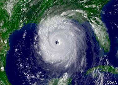 but at least as large as Camille (1969). 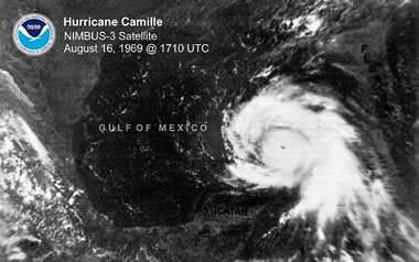 Get to safety, folks. |
|
|
|
[#9]
I did it again setting up a Zello channel
Zello channel is FL Idalia IM me for password https://zello.com/downloads/ or use app store on your phone |
|
|
|
[#10]
Quoted: Getting his dick sucked in the Villages. Quoted: Quoted: Where is Jim Cantore right now? Getting his dick sucked in the Villages.  Figured he’d be more of a “blow-job” guy… |
|
|
|
[#11]
Quoted: This new wave that's hitting south of Tampa now is bringing it. Wind and rain coming down. Tough thing is that it is traveling due north so the band is hitting the same location vertically instead of sweeping through like a horizontal band would. Those in St Pete and Tampa should start getting it within the next 30 minutes or so. Hopefully the land will break it up before it gets up there We’ve been getting it for a few hours. Not much worse than a garden variety thunderstorm, without the thunder. Hopefully it stays that way. Largo/Seminole border, about 3 miles inland. |
|
|
|
[#12]
Quoted: I did it again setting up a Zello channel Zello channel is FL Idalie IM me for password https://zello.com/downloads/ or use app store on your phone |
|
|
|
[#13]
Ten miles south of Tampa and just woke up from 4 hour power nap so i can stay up until daylight.
Very light rain and 10 mph wind at 10:24 ... It should start getting sporty pretty soon. Just another hurricane party going on since 1965 Got some buddies up around Cedar Key, they have been pulling hunting camps and air boats inland all day. That area will takea long time to get back |
|
|
|
[#14]
Quoted: Figured he’d be more of a “blow-job” guy… Met him at church once. Didn’t really seem like a guy who would suck a dick but whatever. |
|
|
|
[#15]
As a born and raised Florida Man and I rebel against this. I hate everything about the Villages... However as some one that has raised 5 daughters.. those are NOT Loofah's. Do even try bra! That sir's is a scrubbie! Freaking armatures |
|
|
|
[#16]
Stay safe everyone. I rode out Ida, so I know what y'all are going to be dealing with. She was a Cat 4.
|
|
|
|
[#17]
Stupid
Zello channel is FL Idalia IM me for password https://zello.com/downloads/ or use app store on your phone |
|
|
|
[#18]
Going to bed. Daughter is sleeping in the hallway. She's eight so she thinks it's fun. Figure either the wind or the power going out will wake me up tomorrow morning. Good luck everyone.
|
|
|
|
[#19]
Quoted: Going to bed. Daughter is sleeping in the hallway. She's eight so she thinks it's fun. Figure either the wind or the power going out will wake me up tomorrow morning. Good luck everyone. Good Luck and God Bless! |
|
|
|
[#20]
Wesley Chapel checking in. Not much action so far but rain is starting to pick up. Walked the dogs around 930 and there was a breeze and some sprinkles. Praying for those northwest of here.
|
|
|
|
[#21]
Quoted: As a born and raised Florida Man and I rebel against this. I hate everything about the Villages... However as some one that has raised 5 daughters.. those are NOT Loofah's. Do even try bra! That sir's is a scrubbie! Freaking armatures Quoted: As a born and raised Florida Man and I rebel against this. I hate everything about the Villages... However as some one that has raised 5 daughters.. those are NOT Loofah's. Do even try bra! That sir's is a scrubbie! Freaking armatures I am not a fan either. I would rather live in Waldo than the Villages. Even freight the trains rolling through town all night would definitely be better than living full-time in The Villages. |
|
|
|
[#22]
Still calm in Lutz/Land O Lakes
|
|
|
|
[#23]
Quoted: https://media.makeameme.org/created/thats-one-huge.jpg It appears clearly smaller than Katrina (2005), https://geology.com/hurricanes/largest-hurricane/hurricane-katrina.jpg but at least as large as Camille (1969). https://geology.com/hurricanes/largest-hurricane/hurricane-camille.jpg Get to safety, folks. Hurricane Ike 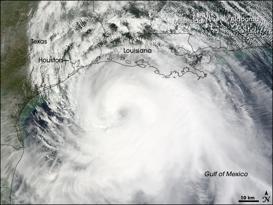  |
|
|
|
[#24]
Quoted: I forgot all about the weather thing and went shopping last night at WD. Oh, the frenzied humanity! People were bitching about not having water on the shelves and how Sam's Club AND Costco were out of the precious resource too. I shopped, and was in line behind a gal that was totally freaking out - YA GOT NO WATER!!! And then, her card got declined. AAAIIIIEEEEEEE!!!! At that point I kinda mentioned that she's probably got 35 gallons of water in her water heater, and a few more in the tank behind her toilet. Wish I would have filmed it. Then tell her she can scoop up ditch water to flush her toilet. |
|
|
|
[#25]
Touche' |
|
|
|
[#26]
Hunkered down for a few hours. Might see if I can film the eye wall passing over, since it looks like it's going over my house
|
|
|
|
[#27]
Hurricane Idalia Advisory Number 14
NWS National Hurricane Center Miami FL AL102023 1100 PM EDT Tue Aug 29 2023 ...IDALIA STILL STRENGTHENING... ...FORECAST TO BE AN EXTREMELY DANGEROUS CATEGORY 4 INTENSITY AT LANDFALL... SUMMARY OF 1100 PM EDT...0300 UTC...INFORMATION ----------------------------------------------- LOCATION...27.7N 84.5W ABOUT 125 MI...200 KM W OF TAMPA FLORIDA ABOUT 185 MI...300 KM S OF TALLAHASSEE FLORIDA MAXIMUM SUSTAINED WINDS...110 MPH...175 KM/H PRESENT MOVEMENT...N OR 10 DEGREES AT 18 MPH...30 KM/H MINIMUM CENTRAL PRESSURE...958 MB...28.29 INCHES WATCHES AND WARNINGS -------------------- CHANGES WITH THIS ADVISORY: The Tropical Storm Warning for the Dry Tortugas is discontinued, and the Tropical Storm Watch for the Lower Florida Keys is discontinued. DISCUSSION AND OUTLOOK ---------------------- At 1100 PM EDT (0300 UTC), the center of Hurricane Idalia was located near latitude 27.7 North, longitude 84.5 West. Idalia is moving toward the north near 18 mph (30 km/h). A northward to north-northeastward motion is expected through tonight, with Idalia's center forecast to reach the Big Bend coast of Florida on Wednesday morning. After landfall, the center of Idalia is forecast to turn toward the northeast and east-northeast, moving near or along the coasts of Georgia, South Carolina, and North Carolina late Wednesday and Thursday. Hurricane Hunter aircraft data indicate that maximum sustained winds are near 110 mph (175 km/h) with higher gusts. Additional strengthening is forecast, and Idalia is expected to become a major hurricane during the next few hours before it reaches the Big Bend coast of Florida. Idalia is likely to still be a hurricane while moving across southern Georgia, and possibly when it reaches the coast of Georgia or southern South Carolina on Wednesday. Hurricane-force winds extend outward up to 25 miles (35 km) from the center and tropical-storm-force winds extend outward up to 160 miles (260 km). The estimated minimum central pressure based on Hurricane Hunter aircraft observations is 958 mb (28.29 inches). |
|
|
|
[#28]
11pm update:
Shifted slightly west Landfall estimated Jefferson/Taylor line Projected Cat4 130mph winds Landfall looking like 8ish |
|
|
|
[#29]

|
|
|
|
[#30]
Quoted: 11pm update: Shifted slightly west Landfall estimated Jefferson/Taylor line Projected Cat4 130mph winds Landfall looking like 8ish I feel bad for the people who are going to be impacted by this storm but after Ian this one hitting a low population area is a blessing. Go back to the first couple pages and people blowing it off as making landfall as 'weak' storm. These things can blow up very quickly and are unpredictable despite modern modeling with super computers being put into the process. |
|
|
|
[#31]
Quoted: I feel bad for the people who are going to be impacted by this storm but after Ian this one hitting a low population area is a blessing. Go back to the first couple pages and people blowing it off as making landfall as 'weak' storm. These things can blow up very quickly and are unpredictable despite modern modeling with super computers being put into the process. |
|
|
|
[#32]
God speed to the folks in the big bend area. This will be a rough one
|
|
|
|
[#33]
stay safe guys
|
|
|
|
[#34]
Quoted: Just finished with second band in Fort Myers near Colonial. Radar looks like a third band is inbound within the next 45 minutes or so. God Bless to our brothers and sisters up in Apalachee Bay, Steinhatchee, the Big Bend, and Cedar Key, as well as along the St Mary's and the eastern Panhandle. This one is going to be a wet one! My brother lives just off Colonial. He was not too worried about this storm. |
|
|
|
[#35]
They’re already seeing power outages in the Tampa area and it hasn’t even done much yet.
|
|
|
|
[#36]

|
|
|
|
[#37]
Quoted: They're already seeing power outages in the Tampa area and it hasn't even done much yet. |
|
|
|
[#38]
Idalia is about 1/4 the size of Katrina. Katrina's hurricane force winds extended 105 miles from the center so 210 mile wide hurricane force wind field.
Idalia hurricane force wind field extends only 25 miles from the center, so 50 mile wide hurricane force wind field. People in the eye path will get wrecked either way, but for most inland people it's gonna be tropical storm. The coastline where it lands though is conducive to large storm surge. It's gonna pile the surge up in the bend of FL. |
|
|
|
[#39]
Prayers sent to those of you riding this one out.
|
|
|
|
[#40]
Quoted: Same for Lake City Lights haven’t even flickered at my place and we normally are the first to loose power |
|
|
|
[#41]
Quoted: They’re already seeing power outages in the Tampa area and it hasn’t even done much yet. She is pretty far off the coast We saw almost no wind in Ellington/Parrish so far |
|
|
|
[#42]
Hermine wrecked Tallahassee and that was a Cat 1. Michael hit Mexico Beach and Tallahassee still got battered. If this goes the way I think it is going, Tallahassee is going to look like Marianna after Michael.
|
|
|
|
[#43]
Quoted: When they said it was going over the eastern gulf and all that hot water, I know it was gonna be a bad one, but I didn't expect a Cat 4. I thought Cat 2-3 Quoted: Quoted: I feel bad for the people who are going to be impacted by this storm but after Ian this one hitting a low population area is a blessing. Go back to the first couple pages and people blowing it off as making landfall as 'weak' storm. These things can blow up very quickly and are unpredictable despite modern modeling with super computers being put into the process. Not trying to dunk on anyone or anything just pointing out the unpredictable nature of these things. As you said, all that hot water being above normal in the Gulf this year at least sets up highly favorable sea surface temperatures for these to blow up in short order. A ton of scientific effort goes into storm predictions and especially hurricane models. It's still science, though, and putting out a model is a hypothesis that is constantly evolving. |
|
|
|
[#44]
Quoted: Hermine wrecked Tallahassee and that was a Cat 1. Michael hit Mexico Beach and Tallahassee still got battered. If this goes the way I think it is going, Tallahassee is going to look like Marianna after Michael. Hurricane Kate was a rough one for Tally also |
|
|
|
[#45]
Almost 10k outages between Duke and TECO now. Gonna be a long night.
|
|
|
|
[#46]
Quoted: Hurricane Kate was a rough one for Tally also Quoted: Quoted: Hermine wrecked Tallahassee and that was a Cat 1. Michael hit Mexico Beach and Tallahassee still got battered. If this goes the way I think it is going, Tallahassee is going to look like Marianna after Michael. Hurricane Kate was a rough one for Tally also Just remember the difference between total destruction and a few limbs being down can be just a mile or two. I deployed to Michael. Pamama City was devastated, PC beach was not hit bad just on the other side of the bridge. But where Mother Nature was at her angriest she flattened mature pine forests of 1000s of acres and bent I beams. |
|
|
|
[#47]
Any of those members who calling this doom and no big deal gonna be editing their post soon? Looks like decent storm is brewing and I hope it truly no big deal. Good luck gents
|
|
|
|
[#48]
Wind and rain picking up now. Still no more than a run of the mill thunder storm
|
|
|
|
[#49]
Good luck to those in the path of the storm.
|
|
|
|
[#50]
Y’all stay safe
|
|
|
 Win a FREE Membership!
Sign up for the ARFCOM weekly newsletter and be entered to win a free ARFCOM membership. One new winner* is announced every week!
You will receive an email every Friday morning featuring the latest chatter from the hottest topics, breaking news surrounding legislation, as well as exclusive deals only available to ARFCOM email subscribers.

AR15.COM is the world's largest firearm community and is a gathering place for firearm enthusiasts of all types.
From hunters and military members, to competition shooters and general firearm enthusiasts, we welcome anyone who values and respects the way of the firearm.

Subscribe to our monthly Newsletter to receive firearm news, product discounts from your favorite Industry Partners, and more.
Copyright © 1996-2024 AR15.COM LLC. All Rights Reserved.
Any use of this content without express written consent is prohibited.
AR15.Com reserves the right to overwrite or replace any affiliate, commercial, or monetizable links, posted by users, with our own.


