|
[#1]
I used 900', so 1700' would explain the difference and get you to 12000 cfs neighborhood.
Interesting that Mannings (friction) is not a factor in the weir equation. I guess it just changes the shape of the water surface as it flows over the weir and does impact flow in a meaningful way. |
|
|
|
[#2]
Quoted:
why no flow values? have they been lagging? Quoted:
Quoted:
902.54' at 0700 why no flow values? have they been lagging? they come out a few minutes after the water level |
|
|
|
[#3]
Quoted:
why no flow values? have they been lagging? Quoted:
Quoted:
902.54' at 0700 why no flow values? have they been lagging? Yes, the flows were coming a bit later after the elevation measurement ETA: 55059(Outflow)51281 (Inflow) |
|
|
|
[#4]
inflow down to 51281
|
|
|
|
[#5]
Flows:
55K out 51.3K in (down 1K) |
|
|
|
[#6]
Quoted:
This is the longest dam thread on ARFcom. Best dam thread evar |
|
|
|
[#7]
Seriously ProFryan, Thank you for your time, money and effort for keeping us abreast on the dam. I've been following along since the beginning and your hard work made this the best thread for natural disasters.
|
|
|
|
[#8]
Quoted:
I used 900', so 1700' would explain the difference and get you to 12000 cfs neighborhood. Interesting that Mannings (friction) is not a factor in the weir equation. I guess it just changes the shape of the water surface as it flows over the weir and does impact flow in a meaningful way. I used 900 as well. |
|
|
|
[#9]
Quoted:
Do you mean that California will have the worst harvest in 55 years? Well, that's one way to get a few million illegals to move back home. |
|
|
|
[#10]
Quoted:
Yesterday afternoon one of the reports said around 12000 cfs at the level then. I've seen a few differing reports of the weir width which did you use for the calculations? 1730 ft seems to be the right number. Quoted:
Quoted:
At 902.5' I calculate the wier's flow at 5100 cfs, which probably makes sense when comparing the OPs pics of the muddy outflows. To cope with flows we saw Friday, the reservoir would be around 911' (assuming 55k output of the normal spillway). That's a 10' wall of water. Yesterday afternoon one of the reports said around 12000 cfs at the level then. I've seen a few differing reports of the weir width which did you use for the calculations? 1730 ft seems to be the right number. |
|
|
|
[#11]
Quoted:
With even more flooding and the wet season extending it, how do farmers even get into their fields? The lower lying areas in the Valley are not going to be worth much except for rice. Nobody is looking out 6 weeks/6 months in the media, it's all about the daily news cycle which is why it's been ignored up to now. The salmon fingerlings being rescued rated higher. The last time I checked the world radar and panned west into the Pacific it looked like rain for thousands of miles moving toward California - a Pineapple Express - and that is not going to facilitate getting crops in and worked in the early part of the growing season. Back here farmers aware of it would just write off even trying and wait until summer to go for one crop before winter. For big commercial farms it's already not looking good. For legal migrant pickers it's not looking good. I won't be surprised to see lettuce from Guatemala at double the price in stores. It's happened before with rain or frost. We have that problem right now, it's already too warm, but our pattern shows we can get 6-7" of snow and freezing temps late in the spring killing most of the fruit buds and damaging the early wheat. Farming is no bed of roses. We're concerned about a dam collapse but the potential long term impact of a wet spring and early summer means that ag will suffer considerably. During the '87 drought farmers switched up crops and tried pumping the acquifer but the frost in 90-91 was the major issue. It's always somethin'. My Aunt is in the agri-seed business and the wet weather has killed her season. Fields are too soggy to get into and no end in sight. Seed business is different than produce because, as I understand it, the plants take a bit longer to go to seed and the time needed for maturity is flying out the window. |
|
|
|
[#12]
Quoted:
Seriously ProFryan, Thank you for your time, money and effort for keeping us abreast on the dam. I've been following along since the beginning and your hard work made this the best thread for natural disasters. No worries. I'd be out there anyway, you guys bring more knowledge to the table which is nice. I'm kind of shocked actually at the lack of people out where i was. Once I got back to my truck and driving back, no joke I drove by hundreds and hundreds of people looking at maps trying to figure out how to get a good view. Hundreds. |
|
|
|
[#13]
Quoted:
Seriously though, which round for drone? Birdshot? Something a little heavier? Skynet drone loads seem interesting. I wonder what the legalities are for a public agency to use in enforcing a tfr or other restricted airspace. |
|
|
|
[#14]
Quoted:
Seriously ProFryan, Thank you for your time, money and effort for keeping us abreast on the dam. I've been following along since the beginning and your hard work made this the best thread for natural disasters. 
|
|
|
|
[#15]
Tagged.
|
|
|
|
[#16]
So with a name like Oroville, and the erosion taking place, a bit of prospecting might be profitable in a few months.
If that is still legal in Ca. |
|
|
|
[#17]
Is the guy doing the live feed posted yesterday (pseudojd) the OP of this thread? If so, get back out there!

Seriously, I enjoyed whomever was doing the live broadcast. |
|
|
|
[#18]
Nobody's tried to run you out of there OP?
A 76 page thread of a potential disaster with 2 pages devoted to hamburgers, thats arfcom. 
|
|
|
|
[#19]
Quoted:
Nobody's tried to run you out of there OP? A 76 page thread of a potential disaster with 2 pages devoted to hamburgers, thats arfcom. And but hurt. Don't forget the but hurt. |
|
|
|
[#20]
Quoted:
Is the guy doing the live feed posted yesterday (pseudojd) the OP of this thread? If so, get back out there!
Seriously, I enjoyed whomever was doing the live broadcast. Yep |
|
|
|
[#21]
Only coverage other than ARFCOM was a little snippet on the Weather Channel.
|
|
|
|
[#22]
Quoted:
Proof again that ARFCOM is first with the news and often first on the scene. Quoted:
Quoted:
Seriously ProFryan, Thank you for your time, money and effort for keeping us abreast on the dam. I've been following along since the beginning and your hard work made this the best thread for natural disasters. This is no joke. I read about a few things on here and two days later it makes the news. |
|
|
|
[#23]
Headed back out there today?
|
|
|
|
[#24]
Quoted:
So with a name like Oroville, and the erosion taking place, a bit of prospecting might be profitable in a few months. If that is still legal in Ca. |
|
|
|
[#25]
Quoted:
Flows: 55K out 51.3K in (down 1K) so 4 k a sec drop... thats gonna take a looooong time to get any meaningfull storage back... |
|
|
|
[#26]
Quoted:
Is the guy doing the live feed posted yesterday (pseudojd) the OP of this thread? If so, get back out there!
Seriously, I enjoyed whomever was doing the live broadcast. I'm going a little slower today. I'll be out there in ~2 hours. Yes that was me I'm going to remember my hat today! I was in such a hurry to see the actual over topping yesterday. |
|
|
|
[#27]
Quoted:
Ho lee shit! I realized the dam was big, but not that big That earth view really gives it perspective You could build a city on it if you turned it on its side yep its big. holds back a hair over a CUBIC MILE of water |
|
|
|
[#28]
Quoted:
I'm going a little slower today. I'll be out there in ~2 hours. Yes that was me I'm going to remember my hat today! I was in such a hurry to see the actual over topping yesterday. And a tripod! |
|
|
|
[#29]
Quoted:
so 4 k a sec drop... thats gonna take a looooong time to get any meaningfull storage back... Only 15,810 Acres surface area. (just under 700,000,000 sf) at normal operating level. A bit more at full pond. |
|
|
|
[#30]
Quoted:
Proof again that ARFCOM is first with the news and often first on the scene. ProFryan, awesome job! I watched live on Periscope yesterday. Thanks for the hard work. I made my wife and step daughter watch some highlights last night which impressed them. |
|
|
|
[#31]
Quoted:
Best dam thread evar Quoted:
Quoted:
This is the longest dam thread on ARFcom. Best dam thread evar |
|
|
|
[#32]
902.52
|
|
|
|
[#33]
Quoted:
This is no joke. I read about a few things on here and two days later it makes the news. Quoted:
Quoted:
Quoted:
Seriously ProFryan, Thank you for your time, money and effort for keeping us abreast on the dam. I've been following along since the beginning and your hard work made this the best thread for natural disasters. This is no joke. I read about a few things on here and two days later it makes the news. This is true. ARMCOM founders should take this a step further and actually develop this into a business plan and start a "NO FAKE NEWS" network using members as reporters. That would be helpful to the MAGA movement IMO. ProFryan could be the first reporter! Cheers & MAGA! Go ARF |
|
|
|
[#34]
Quoted:
So with a name like Oroville, and the erosion taking place, a bit of prospecting might be profitable in a few months. If that is still legal in Ca. Feather River used to be a good gold mining panning river back in the day coming out of the gold rich Sierras When the water drops who knows what will be exposed. Next week though the weather looks pretty sketchy |
|
|
|
[#35]
Quoted:
I'm going a little slower today. I'll be out there in ~2 hours. Yes that was me I'm going to remember my hat today! I was in such a hurry to see the actual over topping yesterday. Good deal! Myself and many others following this thread appreciate the effort. I'm sure the scene is amazing in person and you're lucky to witness it. |
|
|
|
[#36]
hmm... Lake levels peaked at 902.59 at 3am. It's down to 902.52 Now.
Outflow from the regular spillway has remained at 55k and inflows have dropped. Inflow is now at 52K... Found this pic probably taken yesterday... still looking for new pictures from today. 
http://www.parks.ca.gov/?page_id=29411 Remains the only live cam up I know about. |
|
|
|
[#37]
Can someone tell me whats going on?
i dont want to read 76 pages. |
|
|
|
[#38]
So that transmission tower at riverside where the espillway dumps in...disappeared overnight?
|
|
|
|
[#39]
Quoted:
Can someone tell me whats going on? i dont want to read 76 pages. God, or something, is trying to flush the Liberal disease from CA. |
|
|
|
[#40]
Quoted:
Can someone tell me whats going on? i dont want to read 76 pages. Or maybe not What do you want to be true? |
|
|
|
[#41]
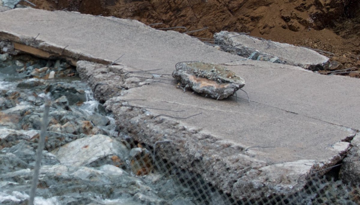
we can put the rebar questions to rest
|
|
|
|
[#42]
Quoted:
So with a name like Oroville, and the erosion taking place, a bit of prospecting might be profitable in a few months. If that is still legal in Ca. @wasted-life CA banned all suction dredging last year. So that is out. But I bet there was some great gold in that bed rock!! |
|
|
|
[#43]
Quoted:
hmm... Lake levels peaked at 902.59 at 3am. It's down to 902.52 Now. Outflow from the regular spillway has remained at 55k and inflows have dropped. Inflow is now at 52K... Found this pic probably taken yesterday... still looking for new pictures from today. https://pbs.twimg.com/media/C4clPtxVYAEt_k6.jpg http://www.parks.ca.gov/?page_id=29411 Remains the only live cam up I know about. Hopefully the chopper will go over again. Until then, those numbers could be made up since they've managed to shut down all non-state approved media, while getting the state-approved media's attention in a bunch of different places. I can't believe they shut off access to any vantage points. I understand closing the close areas for safety reasons, but closing down all of them to prevent looking seems... odd. |
|
|
|
[#44]
Well that answers that.
|
|
|
|
[#45]
Quoted:
Well that answers that. That looks woefully inadequate. I am not an engineer but considering the forces maybe you need steel rod that is several inches in diameter. Or a material that will not rust and disintegrate in the concrete. |
|
|
|
[#46]
Quoted:
So that transmission tower at riverside where the espillway dumps in...disappeared overnight? I don't think so, the e spillway channel carved more upstream. This was yesterday. 
Water has moved away from the tower, and looks like bedrock in between. Thursday's flow could be a different story though. |
|
|
|
[#47]
Quoted:
Can someone tell me whats going on? i dont want to read 76 pages. The dam isn't going to fail. There will be no 21st Century equivalent of the Johnstown Flood. But it's fun fantasizing about that kind of event. |
|
|
|
[#48]
Still no current pics. Interdasting.
|
|
|
|
[#49]
We need to get ProFryan a gift card to In-N-Out Burger...anyone in?
|
|
|
|
[#50]

|
|
|
 Win a FREE Membership!
Sign up for the ARFCOM weekly newsletter and be entered to win a free ARFCOM membership. One new winner* is announced every week!
You will receive an email every Friday morning featuring the latest chatter from the hottest topics, breaking news surrounding legislation, as well as exclusive deals only available to ARFCOM email subscribers.

AR15.COM is the world's largest firearm community and is a gathering place for firearm enthusiasts of all types.
From hunters and military members, to competition shooters and general firearm enthusiasts, we welcome anyone who values and respects the way of the firearm.

Subscribe to our monthly Newsletter to receive firearm news, product discounts from your favorite Industry Partners, and more.
Copyright © 1996-2024 AR15.COM LLC. All Rights Reserved.
Any use of this content without express written consent is prohibited.
AR15.Com reserves the right to overwrite or replace any affiliate, commercial, or monetizable links, posted by users, with our own.


