|
[#1]
I'm sitting here on the back porch drinking some coffee. Just heard a transformer blow.
Hope this ain't a sign of our grid integrity cause the sky is clear right meow |
|
|
|
[#2]
Quoted:
I'm sitting here on the back porch drinking some coffee. Just heard a transformer blow. Hope this ain't a sign of our grid integrity cause the sky is clear right meow |
|
|
|
[#3]
5am out
slight southward movement of forcast path at landfall noted HURRICANE DORIAN FORECAST/ADVISORY NUMBER 20 NWS NATIONAL HURRICANE CENTER MIAMI FL AL052019 0900 UTC THU AUG 29 2019 HURRICANE CENTER LOCATED NEAR 20.5N 66.6W AT 29/0900Z POSITION ACCURATE WITHIN 20 NM PRESENT MOVEMENT TOWARD THE NORTHWEST OR 325 DEGREES AT 11 KT ESTIMATED MINIMUM CENTRAL PRESSURE 991 MB EYE DIAMETER 10 NM MAX SUSTAINED WINDS 75 KT WITH GUSTS TO 90 KT. OUTLOOK VALID 02/0600Z 27.5N 79.5W MAX WIND 110 KT...GUSTS 135 KT. cat 3 max winds |
|
|
|
[#4]
Tag
|
|
|
|
[#5]
Quoted:
5am out slight southward movement of forcast path at landfall noted HURRICANE DORIAN FORECAST/ADVISORY NUMBER 20 NWS NATIONAL HURRICANE CENTER MIAMI FL AL052019 0900 UTC THU AUG 29 2019 HURRICANE CENTER LOCATED NEAR 20.5N 66.6W AT 29/0900Z POSITION ACCURATE WITHIN 20 NM PRESENT MOVEMENT TOWARD THE NORTHWEST OR 325 DEGREES AT 11 KT ESTIMATED MINIMUM CENTRAL PRESSURE 991 MB EYE DIAMETER 10 NM MAX SUSTAINED WINDS 75 KT WITH GUSTS TO 90 KT. getting error trying to upload copy of current forecast What is the minimum pressure stuff? |
|
|
|
[#6]
Track is moving south with landfall near Vero Beach.
|
|
|
|
[#7]
minimal central pressure gives an idea of the intensity of the hurricane. generally, the lower the pressure, the stronger (higher intensity) the winds are.
from comparing to data from before, the system has slowed down it's movement somewhat, thus giving it possibly more time to get stronger in favorable conditions. the eye diameter gives an idea of how large an area the max winds are. the sept 2 outlook, I put, because that is the forecast max wind intensity at that day, which should be before landfall, which puts it in the cat 3 category, which influences evacuation zones. edit - since it slowed down, we may need another day before the final path and landfall firms up. EdwardAvila - you need to ask and consider what the hurricane plans are if you have a cat 3 moving close or over the island you're on. if you are on the water with no elevation, I'd ask if you're likely to get wind blown surge and high waves and flooding |
|
|
|
[#8]
Quoted:
minimal central pressure gives an idea of the intensity of the hurricane. generally, the lower the pressure, the stronger (higher intensity) the winds are. from comparing to data from before, the system has slowed down it's movement somewhat, thus giving it possibly more time to get stronger in favorable conditions. the eye diameter gives an idea of how large an area the max winds are. the sept 2 outlook, I put, because that is the forecast max wind intensity at that day, which should be before landfall, which puts it in the cat 3 category, which influences evacuation zones. Then it changed to wind speed at ground level. Now I believe it's wind speed at 1000' or some height. 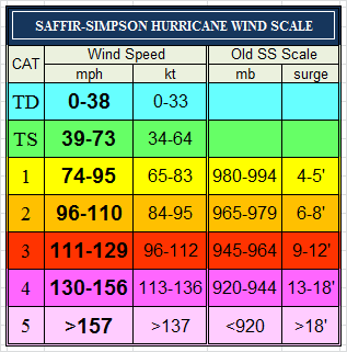
|
|
|
|
[#9]
I really hope this doesn't hit us in the middle of the night.
|
|
|
|
[#10]
Quoted:
Yeah, the original Saffir Simpson hurricane 'Category' ranking went by pressure and not wind speed. Then it changed to wind speed at ground level. Now I believe it's wind speed at 1000' or some height. https://spaghettimodels.com/images/Saffir-Simpson%20Scale.gif the measurement I see is sustained winds at 10 meters of the water or ground is where it is measured, or calculated off of flight level winds. |
|
|
|
[#11]
Quoted:
Like usual... getting ready to assist and deploy for the storm. 
|
|
|
|
[#12]

|
|
|
|
[#13]
Just turn to the North and head out to sea dammit!!
Or else stay South 
|
|
|
|
[#14]
|
|
|
|
[#15]
|
|
|
|
[#16]
Quoted:
What am I looking at @Chokey ? Quoted:
What am I looking at @Chokey ? |
|
|
|
[#17]
Quoted: train of ships GTFO |
|
|
|
[#18]
Quoted:
train of ships GTFO Quoted:
Quoted:
What am I looking at @Chokey ? |
|
|
|
[#19]
|
|
|
|
[#20]
Any updates to the European model?
|
|
|
|
[#21]
Space Coast checking in. Been a resident for a few years, but this one looks like it's going to pop my cherry.

Watching people freak out at the stores over bread and milk and gas is a bit amusing. All set to go for the apocalypse here, so it's a waiting game now. |
|
|
|
[#22]
Quoted:
I'm sitting here on the back porch drinking some coffee. Just heard a transformer blow. Hope this ain't a sign of our grid integrity cause the sky is clear right meow this might be worth a bookmark Florida power outage map |
|
|
|
[#23]
What does the M mean in the middle of the center dot on the tracking map? I understand H and TS
|
|
|
|
[#24]
Quoted:
What does the M mean in the middle of the center dot on the tracking map? I understand H and TS |
|
|
|
[#25]
Quoted:
I can understand a little of the desensitization. The bombardment of hyperbole is tiresome. Quoted:
Quoted: Boynton Beach. The place was empty of customers too. Personally, I believe folks are putting too much faith in the center of the cone track line. |
|
|
|
[#26]
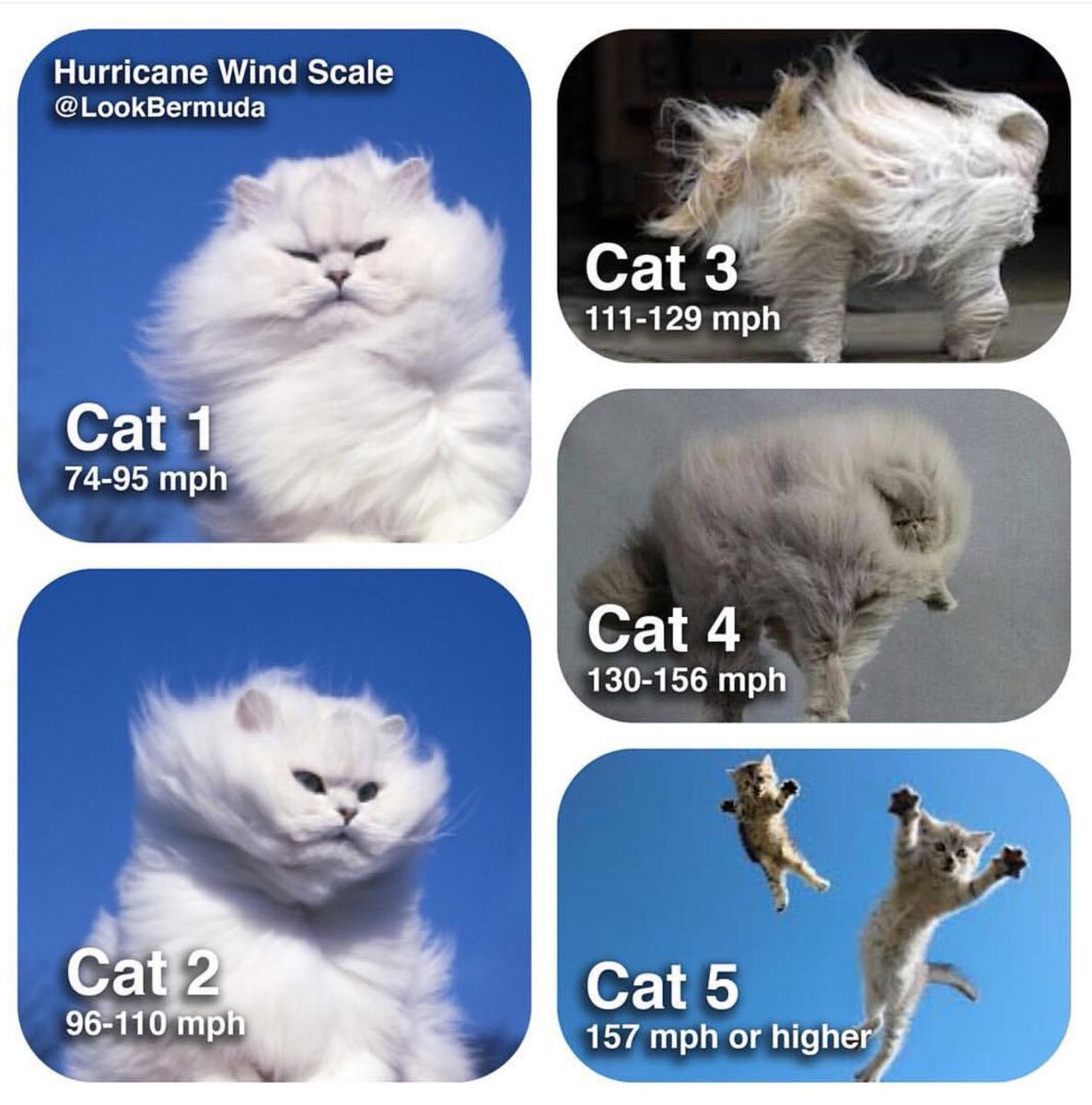
Quoted:
Major Hurricane (Sustained winds > 110 MPH) i.e. CAT III or higher Quoted:
Quoted:
What does the M mean in the middle of the center dot on the tracking map? I understand H and TS 
|
|
|
|
[#27]
Can the people posting updates, please at least post the County they are in?
There’s been a couple people posting useful stuff, useful, that is, if it had a geographical area associated with it. I get the desire for persec. I really do. But don’t post all that stuff if you're not going to post the County or Zipcode at least. |
|
|
|
[#28]
Quoted:
Major Hurricane (Sustained winds > 110 MPH) i.e. CAT III or higher
|
|
|
|
[#29]
The whole slowing down thing sucks. Gonna be over Florida for days.
|
|
|
|
[#30]
Quoted:
Quoted:
Major Hurricane (Sustained winds > 110 MPH) i.e. CAT III or higher
https://pbs.twimg.com/media/CuBfzJ9XgAAgHJs.jpg:large 
|
|
|
|
[#31]
A rather amazing level of model uniformity for so far out.

At least this time it looks like folks in the evacuation area will have the option of north, south, or west. Much preferable to having the 'Cane paralleling the coast. |
|
|
|
[#32]
Any of y’all Broward County kids been out and about? Was wondering if anyone has been to the Parkland BJs recently.
|
|
|
|
[#33]
Quoted:
Tag
@Rumrunner358 |
|
|
|
[#34]
Quoted: EdwardAvila - you need to ask and consider what the hurricane plans are if you have a cat 3 moving close or over the island you're on. if you are on the water with no elevation, I'd ask if you're likely to get wind blown surge and high waves and flooding The boss and I flew one of the King Airs down to Marsh the day after Floyd went through because of zero coms down there. Didn't land because there was at least a foot of water on the runways at both Marsh harbor and Treasure. Once the runways were cleared we were running the Caribou down to Marsh every couple days for a month loaded mostly with insulators, switches, wire spools, transformers and general supplies for rebuilding the power grid. |
|
|
|
[#35]
Double tap
Dang coms going to shit already |
|
|
|
[#36]

|
|
|
|
[#37]
Quoted:
I really hope this doesn't hit us in the middle of the night. |
|
|
|
[#38]
Quoted:
https://pbs.twimg.com/media/EDItDCeU4AAv4X_?format=jpg&name=large |
|
|
|
[#39]
Quoted: @RiverSwine45 this might be worth a bookmark Florida power outage map https://www.AR15.Com/media/mediaFiles/258837/Screen_Shot_2019-08-29_at_7_22_47_AM_png-1071136.JPG |
|
|
|
[#40]
Quoted:
Like usual... getting ready to assist and deploy for the storm. |
|
|
|
[#41]
Quoted:
Gainesville FL already reporting fuel shortages. I topped of around 7:30 and the gas station was packed. Wife hit Publix & Walmart yesterday for normal groceries. Coworkers said Publix was a madhouse today. |
|
|
|
[#42]
Quoted:
Any of y’all Broward County kids been out and about? Was wondering if anyone has been to the Parkland BJs recently. I’m sure it is busier this morning with the storm getting closer. If you need something get in now before the real panic sets in. |
|
|
|
[#43]
Water levels high? Check.
Live in one of two houses that lost power for three hours yesterday for no reason? Check. Maybe I can beat my 2.5 weeks without power record and one year of sawing oak trees record.
|
|
|
|
[#44]
Water levels high? Check.
Live in one of two houses that lost power for three hours yesterday for no reason? Check. Maybe I can beat my 2.5 weeks without power record and one year of sawing oak trees record.
|
|
|
|
[#45]
Quoted:
Guess who drove down to Lake Wales yesterday.  |
|
|
|
[#46]
Pressure is back down to 986mb which is where it was at last night before it ingested some dry air and struggled a bit. I'm thinking in the next 48 hours or so we will see some real intensification.
|
|
|
|
[#47]
Quoted: Yep. They behave more like drama actors than meteorologists. |
|
|
|
[#48]
 Hurricane Dorian Update: August 29 8:45 AM ET |
|
|
|
[#49]
well on the bright side one of my trees just fell on my neighbors brand new fence, you can't see the spot from his house
and with the low pressure coming it would be an epic opening weekend for snook season, and if it comes through just right we wont get the coastal flooding, it will suck all the garbage out of our rivers instead. |
|
|
|
[#50]
Quoted:
I really hope this doesn't hit us I've had it with hurricanes. To make matters worse, I was injured in an accident. I've completely screwed up my ankle (I'm in PT working to avoid surgery) and my wrist. I've been putting off going to the doc for that because of my ankle. But I know something is really wrong with it. I can't help putting up the shutters... or taking them down. Hubby can't do it all by himself. They are heavy bastards. If we can't get some of our friends sons to come over, we may have to resort to hiring people I do not want to hire. I'm not a happy girl right now. I don't do well not be able to do anything. 
|
|
|
 Win a FREE Membership!
Sign up for the ARFCOM weekly newsletter and be entered to win a free ARFCOM membership. One new winner* is announced every week!
You will receive an email every Friday morning featuring the latest chatter from the hottest topics, breaking news surrounding legislation, as well as exclusive deals only available to ARFCOM email subscribers.

AR15.COM is the world's largest firearm community and is a gathering place for firearm enthusiasts of all types.
From hunters and military members, to competition shooters and general firearm enthusiasts, we welcome anyone who values and respects the way of the firearm.

Subscribe to our monthly Newsletter to receive firearm news, product discounts from your favorite Industry Partners, and more.
Copyright © 1996-2024 AR15.COM LLC. All Rights Reserved.
Any use of this content without express written consent is prohibited.
AR15.Com reserves the right to overwrite or replace any affiliate, commercial, or monetizable links, posted by users, with our own.


